
Iwojima
| Iwojima | ||
|---|---|---|
 |
||
| Waters | Pacific Ocean | |
| Archipelago | Kazan-rettō | |
| Geographical location | 24 ° 46 ′ 40 " N , 141 ° 18 ′ 52" E | |
|
||
| surface | 23.73 km² | |
| Highest elevation |
Suribachi 170 m |
|
| Residents | 400 soldiers 17 inhabitants / km² |
|
| main place | Iōtō (historical) | |
 |
||

Iwo Jima ( Japanese 硫黄島 , iota [ iota ] , even Iojima [ ioːʑima ] , literally "sulfur island") ( ) is a 23.73 square kilometer volcanic island in the Pacific , about 1200 Kilometers south of Tokyo . It belongs to the Kazan-rettō of the Ogasawara Islands .
The island is not accessible to civilians; around 400 Japanese soldiers are stationed on it today . At the request of the previous residents, the island was renamed by the Japanese government back to its original name Iōtō (outdated Iwōtō ) in June 2007 , under which it was known before the Second World War. Japanese naval officers who had been moved there to fortify the island before the battle of Iwojima had interpreted the pronunciation of the kanji for island ( 島 ) as -jima ( kun reading ) instead of -tō ( on reading ).
geology
The 170 meter high Suribachi volcano forms the highest point on the island.
Iwojima is located within a caldera with a diameter of around nine kilometers, which was formed during a volcanic eruption probably 3000 years ago. After the eruption, the refilling of the magma chamber led to the uplift of the caldera floor; between the years 1600 and 2000 the island rose by around 120 meters. Swarms of earthquakes occur. Fumaroles are active on Iwojima . There were minor outbreaks in 1982, 1994, 1999, 2004, 2009 and 2012; these were often phreatic explosions . In September 2001, a submarine eruption occurred about 150 to 200 meters off the southeast coast of the island.
history
colonization
The island was uninhabited until 1889, but was then settled, incorporated into the Japanese state association in 1891 and expanded as a base in the Pacific.
In 1943 the population was 1018 people in 192 households spread over Motoyama ( 元山 , German “ mountain of origin”, the central elevation of the island) and therefore Higashi ( 東 , German “east”), Minami ( 南 , German “ South ”), Nishi ( 西 , German“ West ”) and Kita ( 北 , German“ North ”). The municipal administration, which existed until 1940 (when the municipality was incorporated into Ogasawara ), was responsible for the entire chain of islands Kazan-rettō and thus also for the places Ishinomura and Nishimura on Kita-Iwojima . It was based in Higashi in the east of the island. In 1944 the civilian population was evacuated to the main Japanese islands.
Second World War
During World War II , Iwojima was one of Japan's Pacific bases. She owned three airfields.
The economically unimportant island was of very great strategic importance for both the Japanese and the Americans: The Japanese were able to spot American bomber fleets that were leaving Saipan for Tokyo very early and warn the main island. After conquering this island, it was much easier for the Americans to bomb the main Japanese island, as fighter planes could now accompany the bombers as escorts, which was previously not possible due to the insufficient range. In addition, Iwojima would have played an important role in an invasion of the main Japanese island that did not occur due to the surrender of Japan .
After more than 50 hours of bombing, US troops finally landed on the island on February 19, 1945. The battle for Iwojima turned out to be one of the bloodiest of the Pacific War . According to the historian Samuel Eliot Morison , there were 6,825 dead and 27,909 wounded on the American side, while 20,703 Japanese casualties were recorded. Only 216 Japanese soldiers survived the inferno.
On February 23, 1945, Associated Press photographer Joe Rosenthal took the photo Raising the Flag on Iwo Jima , showing a group of six soldiers hoisting a US flag on the highest point on the island, the Suribachi volcano . The award-winning photo went around the world and has a place in the collective memory of the United States.
post war period
Iwo on a transmitting station was of the radio navigation system LORAN-C of the transmitter chain Grid 9970 ( 24 ° 48 '6 " N , 141 ° 19' 30" O ). The transmitter had a transmission power of 4000 kW, making it one of the most powerful transmitters in the world. In 1965, the station's 411.5 m high transmitter mast overturned during maintenance work and also destroyed the transmitter building and all of its technical equipment. The system was rebuilt and again received a 411.5 m high transmission mast. In September 1993 it was shut down and the antenna mast dismantled.
Political situation
Iwojima was annexed by Japan in 1877 and was occupied by the United States until 1968 after World War II. It was then returned to Japan. Today the island is not permanently inhabited and serves as a military base for Japan. Special permission is required for entry.
economy
Sugar cane was cultivated in the north of the island until 1944 . On the "Sulfur Island" also has sulfur mined.
Film adaptations
Clint Eastwood filmed the Battle of Iwojima from 1945 in 2006. Since he only received a limited filming permit for the island, he had to shoot in Iceland and Barstow ( California ). It was remarkable that Eastwood made two films at the same time: Flags of our Fathers from the perspective of the Americans and Letters from Iwo Jima from the perspective of the Japanese. Flags of our Fathers is based on the book of the same name by James Bradley.
As early as 2004, the episode The Hero of Iwo Jima of the television series Navy CIS dealt with Iwojima, mentions the 1940 film Sands of Iwo Jima with John Wayne and anticipates Eastwood's parallelism in parts.
The eighth episode of the 2010 HBO miniseries The Pacific deals in part with the battle for Iwojima and in particular the death of the American war hero John Basilone during the same.
gallery
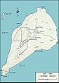
Map with districts 1945

Detailed map from September 2, 1944

Satellite image, false colors
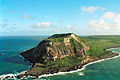
Suribachi

Site of the invasion from Suribachi summit
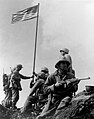
Hoist the first flag

The monument to the Battle of Iwojima

Ships in front of the Suribachi volcano on Iwojima Island. In the foreground the USS Carl Vinson

.jpg)


_and_USS_Sacramento_(AOE-1)_off_Iwo_Jima_in_May_2003.jpg)
Web links
- Iwojima in the Global Volcanism Program of the Smithsonian Institution (English)
- National Archives: Flag Raising Photo by Rosenthal ( Memento from December 8, 2007 in the Internet Archive )
- ap page on the story of Joe Rosenthal's Iwojima photo ( memento from March 3, 2012 in the Internet Archive )
- National Park Service: US Marine Corps War Memorial (official site; English)
- Andreas Spinrath: Battle of Iwojima: Island of blood and ashes. In: one day . February 17, 2015, accessed February 17, 2015 .
- Flags of our Fathers - the movie
- Searching for traces on Iwo Jima (article publishedon January 12, 2007 in the NZZ )
Individual evidence
- ↑ 島 面積 . (PDF; 144 KiB) (No longer available online.) Kokudo Chiriin , October 1, 2014, archived from the original on April 2, 2015 ; Retrieved July 28, 2016 (Japanese). Info: The archive link was inserted automatically and has not yet been checked. Please check the original and archive link according to the instructions and then remove this notice.
- ^ Japan changes name of Iwo Jima. USA Today , June 20, 2007; accessed June 19, 2009 .
- ^ Jacob B. Lowenstern, Robert B. Smith, David P. Hill: Monitoring super-volcanoes: geophysical and geochemical signals at Yellowstone and other large caldera systems. In: Philosophical transactions of the Royal Society , (2006) 364, pp. 2055–2072, here pp. 2066–2068 (English; PDF: 999 KiB)
- ↑ In September, a submarine eruption; in October, a phreatic eruption pierces beach . Monthly report 09/2001 in the Global Volcanism Program (accessed on March 3, 2013)
- ↑ A bridgehead for the conquest of Japan , NZZ, February 18, 2015