Zobor Monastery
The Zobor Monastery was the oldest monastery on the territory of today's Slovakia . It was from 9/11. a Benedictine monastery up to the 15th century and a Camaldolese monastery in the 17th and 18th centuries .
investment
The monasteries were located at the western foot of Mount Zobor, three kilometers north of the historic center of Nitra on an important trade route ( Amber Route ) from the Baltic Sea to the Adriatic. Remains of the church of St. Joseph of the baroque Camaldolese monastery and a building have been preserved. The facility can be visited from May to September.
history
Benedictine monastery
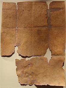
The beginnings of the monastery are very uncertain. A monastery is said to have existed as early as the end of the 9th century and the Moravian prince Svatopluk spent his last lifetime there (legendary). In the early 11th century, some hermits are said to have lived around Saint Zorad on Mount Zobor . The first documents that have been preserved are from the years 1111 and 1113 and contain a list of properties with associated villages by the Hungarian King Koloman . In 1468 the monastery was closed by King Matthias Corvinus . The complex was destroyed in 1471 by the Polish king's son Casimir .
Camaldolese monastery
In 1663 a chapel was built in the remains of the monastery. Camaldolese monks came from Kahlenberg near Vienna and were able to open a new monastery in 1691. In 1782 this was closed by Emperor Josef II in the course of his secularization.
Further use
A factory was built on the site in 1786 and a sanatorium since 1886. Today there is a special clinic on one part, while the remaining remains of the Camaldolese monastery can be visited on another part.
literature
- Imrich Točka: Zobor . Vlastný náklad, Nitra 2014. ISBN 978-80-971790-3-8 . Pp. 33-36.
Web links
- Zoborský kláštor (Slovak)
- Zobor Monastery (German)
- Zoborský kláštor website of the exhibition site (Slovak)
Individual evidence
- ↑ Location of the remains of the monastery and information on archaeological investigations Zobor (pdf, Slovak)
- ↑ On the legendary traditions of Johann Nepomuk Vogl: The Kahlenberg near Vienna and its inhabitants. 2nd, improved edition, Vienna 1846. pp. 45f.
Coordinates: 48 ° 20 ′ 42.1 ″ N , 18 ° 5 ′ 29.9 ″ E


