
Koishikawa Kōrakuen
.JPG)
The Koishikawa Korakuen ( Japanese 小石川後楽園 ) is an urban park (7 hectares) in the district of Koraku Bunkyō (formerly Koishikawa ), Tokyo , from the garden of the former city residence of Mito - han emerged.
history

The system of Koishikawa Kōrakuen was started by the first head of the house of the Mito branch of the Tokugawa , Tokugawa Yorifusa , in 1629, but only completed under his grandson Tokugawa Mitsukuni in 1669 with the help of the scholar Zhu Shunshui ( 朱 舜 水 , 1600–1682), who fled from China .
The name kōraku for "post-enjoyment" is a quote from Chinese scriptures, where en means "garden".
The Kōrakuen is the oldest convertible garden-style complex in Tokyo. The center of such gardens is almost always a pond system that is fed by running water. Together with artificial hills, a miniature landscape is created that invites you to stroll through.
Overview
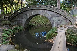
The Kōrakuen contains allusions to Chinese and Japanese landscapes, the latter especially in relation to Kyōto . The “reproduced” Chinese landscapes include, for example, the small Lu mountain , the famous dam through the West Lake . The island of the lucky ones, Hōrai Island, is located in the central body of water. And so that no one is neglected, there is a shrine on the heights of the island, which is dedicated to the goddess Benzaiten . The allusions to Kyoto include the Tōgetsu Bridge, the Tsuten Bridge, the Ōi River and the Kiyomizu Temple . Copied from the mountains behind Osaka is the Tatsuta River, which is famous for its maple trees, and the Kiso River from Central Japan . The semicircle of the stone Engetsu Bridge forms a full moon = Engetsu with its mirror image. The residence used to begin on the somewhat separated part of the garden. It was long gone and is now occupied by the Tokyo Dome , a covered baseball stadium.
The Koishikawa, a small stream that gave the area its name, provides this garden with water before the Naruto Whirlpools (this is the swirl in the eastern strait between Shikoku and the main island) passes, and ultimately into the Sumida River enters .
In 1952 the complex was declared a special historical site ( tokubetsu shiseki ).
The gardens
(The numbers refer to the garden plan shown.)
- 涵 徳 亭 門 (西門) , Kantokutei-mon (Saimon): Gate at the Kantoku pavilion (west entrance)
- 庭園 事務所 , Teien-jimusho: garden management
- 菊 形 手 水 鉢 , Kikugata chōzu-bachi: hand wash basin in the shape of a chrysanthemum
- 涵 徳 亭 , Kantoku-tei: Kantoku pavilion
- 鉄 砲 垣 , Teppō-gaki: "rifle fence"
- 桃山 形 灯 篭 , Momoyama-gata tōrō: Momoyama-style stone lantern
- 飾 手 水 鉢 , Kazari chōzu-bachi: decorated hand basin
- 枯 滝 , Kare-taki: Dry waterfall
- 雪見 灯 篭 , Yukimi- dōrō : Yukimi-style stone lantern
- 陽 石 , Yōseki: Male stone
- 枝 垂 桜 , Eda dare sakura: hanging cherry
- 陰 石 , inski: female stone
- 水 掘 れ 石 , Mizu-bore ishi |: water drop stone
- 小 廬山 , Shō Ro-san: Little Lu Shan , China
- 渡 月 橋 , Togetsukyō: moon bridge, Kyōto
- 西湖 堤 , Saiko tei: Dam in the West Lake , China
- 屏風 岩 , Byōbu iwa: "stone curtain"
- 大 堰 川 , Ōigawa: River in Kyōto
- 清水 観 音 堂 跡 , Kiyomizu kannondō ato: Remains of the Kannon Hall, Kiyomizu-dera , Kyōto
- 通 天橋 , Tsūtenkyō: "Bridge to Heaven", Kyōto
- 沢 渡 り , Sawatari: step stones to cross shallow water
- 音 羽 滝 , Otowa no taki: allusion to the Otowa waterfall on the northern trans of Kyōto
- 得 仁 堂 , Tokujindō: Confucian shrine
- 丸 屋 の 跡 , Maroya no ato, traces of a hut "Maroya" that is covered with straw / reeds
- 蓮 の 池 , Hasu ike: lotus pond
- 一 つ 松 , Hitotsu matsu: single red pine
- 沢 渡 り , Sawatari: step stones to cross shallow water
- 白 糸 滝 , Shiraito no taki: "White thread waterfall"
- 伽藍 石 , Garan seki: base stones of temple columns
- 松林 , Matsubayashi: pine forest
- 円 月 橋 , Engetsukyō: stone "full moon bridge"
- 愛 宕 坂 , Atago saka: stone stairs to the Atago shrine, Kyōto, Edo
- 八卦 堂 跡 , Hakkedō ato: traces of the Hakke pavilion
- 小 町 塚 , Komachi-zuka: hill for Ono no Komachi
- 梅林 , Bairin: plum forest
- 琴 画 亭 跡 , Kingatei ato: traces of the Kinga Pavilion
- 八 つ 橋 , Yatsubashi: flat bridge in a zigzag shape
- 石橋 , Ishibashi: stone bridge made of Nebukawa stone ( 根 府 川 石 )
- 不 老 の 水 , Furō no mizu: spring water of eternal youth
- 藤 棚 , Fujidana: Wisteria trellis
- 1 花 菖蒲 田 , Hanashōbu-en: Iris field
- 稲 田 , Inada: field for planting rice
- 九八 屋 , kuhachi ya: "nine-eight pavilion" (rural sake bar)
- 遠 州 形 灯 篭 . Enshū-gata dōrō: Stone lantern in the style of Kobori Enshū
- 船 着 場 , Funatsukiba: dock for boats
- 異形 灯 篭 , Ikei-dōrō: irregular stone lantern
- 蓬莱 島 , Hōraijima: Island with the Mountain of the Blessed ( Penglai , China)
- 弁 財 天 祠 , Benzaitenshi: Shrine for Benzaites
- 瘞 鶏 碑 , Eiyō-hi: Monument to the falcon of the 7th ruler of the fief Mito
- 竹 生 島 , Chikubu-shima: Island in the north of the Bivouac
- 鳴 門 , Naruto : Sea vortex between Shikoku and Awajishima:
- 唐門 跡 , Karamon ato: traces of the gate in the Karamon style
- 内 庭 , Naitei: Inner garden
- 正門 (東門) , Seimon (Higashimon): Old main entrance (east gate), but closed
- 記念 碑 , Kinenhi: Monument with the floor plan of the Mito fiefdom's secondary residence
- 延 段 , Nobedan: steps covered with tiles
- 寝 覚 滝 , Nezame no taki: "Waterfall for / when waking up", on the Kiso / river
- 木 曽 川 , Kisogawa: important river in Hida Province
- 白雲嶺 , Hakuun-rei: Hill "White Clouds"
- 紅葉 林 , Momiji-bayashi: autumn foliage grove
- 徳 大寺 石 , Tokudaiji-seki: stone of / from Tokudai-ji
- 竜 田 川 , Tatsutagawa: allusion to the Tatsuda River
- 帛 (幣) 橋 , Nusabashi: stone bridge
- 駐 歩 泉 , Chūhosen: stopping at the water
- 歌 碑 , Uta ishibumi: Monument to Waka
- 西行 堂 跡 , Saigyō-dō ato: traces of the Saigyō's hut
- 朝鮮 燈籠 , Chōsen tōrō: Korean stone lantern
gallery

Small mountain Lu

Shiraito waterfall.jpg

"Eight Bridge" (Yatsuhashi)

Kiyomizu Kannon-do and Tsutenbashi (model)

View of Horaijima

View of Horaijima
Engetsu Bridge

Tsūten Bridge


Characteristics
- Carrier: Tokyo Prefecture. Entry is charged.
- Opening: April 3, 1938.
- Area: 70,847.17 m², 1,300 m² of which is lawn.
- Tree population: 4030 trees, 168 bushy (1995).
- Attachments: Space available for meetings: Kantokutei.
- Awards: "Special historical traces" ( 特別 史跡 ), "Special scenic sight" ( 特別 名勝 )
literature
- Tōkyō-to kōen kyōkai (Ed.): Koishikawa Kōrakuen , before 1985, 16 pp. [In Japanese]
- Leaflet yum garden, 2007
- Tokyo-to rekishi kyoiku kenkyukai (ed.): Tokyo-to no rekishi sampo (chu). Yamakawa Shuppan, 2000. ISBN 978-4-634-29630-5 . Pp. 149-150.
Web links
Individual evidence
- ↑ Based on a waka by Saigyō.
- ↑ Yatsu is the number eight, but the name does not refer to the number, but to the form 八 .
Coordinates: 35 ° 42 ′ 20 " N , 139 ° 44 ′ 57" E