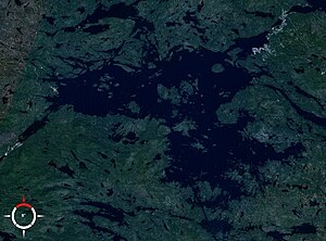
Kowdosero
| Kovdosero Ковдозеро, Knjaschegubsk Hydroelectric Power Plant |
|||||||
|---|---|---|---|---|---|---|---|
|
|||||||
|
|
|||||||
| Coordinates | 66 ° 46 ′ 59 ″ N , 32 ° 0 ′ 0 ″ E | ||||||
| Data on the structure | |||||||
| Construction time: | 1955-1957 | ||||||
| Power plant output: | 152 MW | ||||||
| Data on the reservoir | |||||||
| Altitude (at congestion destination ) | 37 m | ||||||
| Water surface | 608 km² | ||||||
| Reservoir length | 48 km | ||||||
| Reservoir width | 23 km | ||||||
| Catchment area | 25th 900 km² | ||||||
Kowdosero ( Russian Ковдозеро ) is a lake in the south of the Murmansk Oblast in northwestern Russia . There are a number of islands in the lake. In 1955, the Knjaschegubsk hydroelectric power station was built, and the natural lake was dammed by 6.4 m. The original lake area grew from 224 to 294 km² to 608 km². The catchment area covers 25,900 km².
The lake is fed by many rivers. The most important tributaries are Kowda and Lopskaja . Since the lake was converted into a reservoir, the water of the Kowdosero has flowed through a canal to the hydroelectric power station and on to the White Sea .
The lake is used for fishing , shipping and logging .
Web links
Commons : Kowdosero - collection of images, videos and audio files
- Entry in the North encyclopedia (English / Russian)
Individual evidence
- ↑ a b Article Kowdosero in the Great Soviet Encyclopedia (BSE) , 3rd edition 1969–1978 (Russian)
- ↑ Kowdosero in the State Water Register of the Russian Federation (Russian)


