Kujūkushima
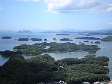
Kujūkushima ( Japanese 九 十九 島 ) is a group of islands off the Japanese main island of Kyūshū in the west.
The name of the archipelago literally means "ninety-nine islands", but their number is officially given as 208. The islands, which are almost all mountainous, forested and uninhabited, belong partly to the urban area of Sasebo , partly to the city of Hirado . The islands are part of the Saikai National Park .
The two largest islands, Kuroshima and Takashima, can be reached by car ferry three times a day from Ainoura, a port north of Sasebo.
Kuroshima
The island of Kuroshima ( 黒 島 ), whose name literally means "Black Island", is the largest island in the archipelago with an area of 5.3 km².
Of the 650 inhabitants (2005 census), 80% are Roman Catholic and not a few of them are descendants of Christians who sought refuge here after the Shimabara uprising in 1637 in order to escape the persecution of Christians under Tokugawa Ieyasu .
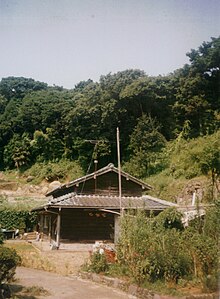
Kuroshima is mountainous and even today it is still densely forested in places. Most of the residents still live from agriculture and fishing, some commute to work on the mainland every day. In the interior of the island, rice terraces have been created in some places, which is rather untypical for Japan. Farmhouses in the traditional style have also been preserved.
The main attraction of Kuroshima is the Kuroshima Tenshudō Church, built in 1902 . Rising almost exactly in the middle of the island, it is one of the very few brick churches in Japan. In 1998 it was officially declared an “ important cultural asset ”. Not far from the church are the school and the administration of the island as well as shops.
Takashima
Takashima ( 高 島 ), the second largest island of the Kujūkushima archipelago, covers an area of 2.6 km² and counted 239 inhabitants in the 2005 census. The name of the island literally means "high island". The highest elevation is 138 m.
Individual evidence
- ↑ a b 西海 路 を 巡 る . (No longer available online.) Nagasaki Prefecture, p. 3 , formerly original ; Retrieved February 16, 2012 (Japanese). ( Page no longer available , search in web archives ) Info: The link was automatically marked as defective. Please check the link according to the instructions and then remove this notice.
- ↑ Chris Taylor: Japan , Lonely Planet, Berlin 1998, p. 632.
Web links
- The introduction of Saikai National Park Kujū-ku Islands (at the Saikai Pearl Sea Resort site) (Japanese)
- Saikai Pearlsea RESORT Official Site (English)
Coordinates: 33 ° 10 ' N , 129 ° 36' E


