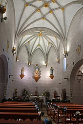
La Puebla de Fantova
| Graus municipality: La Puebla de Fantova | ||
|---|---|---|
 Ermita Santa Cecília
|
||
| coat of arms | Map of Spain | |
 Help on coat of arms |
|
|
| Basic data | ||
| Autonomous Community : |
|
|
| Province : | Huesca | |
| Comarca : | Ribagorza | |
| Coordinates | 42 ° 16 ' N , 0 ° 24' E | |
| Height : | 700 msnm | |
| Residents : | 110 (2019) INE | |
| Postal code : | 22437 | |
| Area code: | 22117001300 | |
La Puebla de Fantova is a Spanish village in the province of Huesca in the autonomous community of Aragon , which belongs to the municipality of Graus . The place at about 700 meters above sea level is about seven kilometers northeast of Graus.
La Puebla de Fantova was an independent municipality until the 1960s.
Attractions
- Parish Church of Nuestra Señora de la Asunción , built in the 16./17. century
- Castle, built in 10/11. century
- Ermitas de San Clemente Tobeña , built in the 11th / 12th centuries. century
- Ermita de Santa Cecilia , built in the 12th century
- Ermita de San Gregorio , built in the 12th century
- Ermita de Llagure , built in the 17th century
literature
- Cayetano Enríquez de Salamanca : Rutas del Románico en la provincia de Huesca . Enríquez de Salamanca Editor, 2nd edition, Madrid 1993, ISBN 84-398-9582-8 , pp. 110-112.
Web links
Commons : La Puebla de Fantova - Collection of images, videos and audio files


