Laak (Koenigsberg)
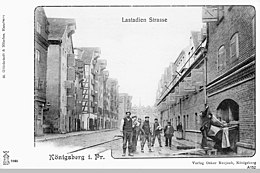
Laak or Laack or Lastadie was a district of Königsberg (Prussia) , a suburb to the west of the castle.
Surname
The name is derived from the Baltic root word "lak" and indicates a swamp area .
location
To the east was the Pregel district across from the Kneiphof . In the west it ended at the city wall at the "Holländischer Baum", where the Reichsbahnbrücke later spanned the Pregel. If you follow the old town Langgasse to the west, you will first reach the Unterlaak and then the Oberlaak.
history
The Laak was initially a freedom belonging to the old town outside the Laakener Tor . All urban freedom enjoyed a certain self-government and received their own coat of arms and their own courts. The residents were parish in the city churches, but had to do interest and crowd services. However, the freedoms were not fortified and were often devastated by enemies. The castle freedom made an exception . Because of its convenient location on the Pregel, many warehouses were built on the Laak to store goods, so that Laak or Lastadie owed their growth to trade. In 1764 a conflagration devastated the place, in which the wind also drove the fire over the Pregel and burned over 300 houses in Sackheim .
The Schroetter map from 1802 only shows buildings on the banks of the Pregel, largely with packing houses. Otherwise there are only meadows here. Towards the “Dutch Tree” were a shipbuilding site, a salt store and the “Dutch shipbuilding site”. To the north of it, in an idyllic location on the wall in a bush, the "Drei-Kronen-Loge" had its property, which later moved to the Tragheim directly at the castle pond. In their place later stood the Army Rescue Office . The main customs office was on the railway bridge . The Reichsbahnbrücke separated Laak from the Kosse district .
literature
- Ludwig von Baczko : An attempt at a history and description of Königsberg. Koenigsberg 1804.
- Fritz Gause : Königsberg in Prussia, Rautenberg Leer 1987
- Vilius Peteraitis: Mažoji Lietuva ir Tvanksta (Lithuania Minor and Tvanksta) Vilnius 1992, para. 9.6.
- Friedrich Leopold von Schrötter : Map of East Prussia with Prussian Litthauen and West Prussia with Netzedistrict 1796–1802, Historical-Geographical Atlas of the Prussia, Franz Steiner Verlag Wiesbaden
Coordinates: 54 ° 42 ′ N , 20 ° 30 ′ E

