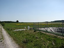
Wet grassland landscape protection area Fractures and forest breaks
The landscape protection area wet grassland forest break with 31.05 hectares is located northwest of Scharfenberg in the urban area of Brilon . The area was designated as a landscape protection area (LSG) by the Hochsauerlandkreis in 2008 with the landscape plan of the Brilon plateau . The NSG consists of three areas. To the east of the northern area of the LSG, a settlement adjoins the Waldbruch road in one area. The Waldbruch nature reserve borders the north and middle areas of the LSG. While the southern area borders the Brüche nature reserve to the east.
description
LSG is grassland. The landscape plan explains the LSG: “Because of their water content, they are predestined for grassland use; At the same time, they supplement the NSG with open spaces that are important for the ornithological significance of these meadow bird habitats. The two northern sub-areas are separated by an older first afforestation complex over 2 hectares in size, and a sub-area is cultivated here. Drainage and deep side ditches contribute to the drainage, but a number of moisture indicators point to the special potential of the forest break. This potential should be fully developed through the most extensive land use possible (inclusion of the LSG in the HSK's cultural landscape maintenance program). The southern part of the area has a similar meaning for the NSG 'Brüche' - here, too, it is a large grassland complex with considerable importance for the protection of species and biotopes (especially the protection of endangered bird species). At the same time, this slightly inclined grassland area, located on a valley watershed, represents a buffer zone to the uses of the settlements adjoining to the east. Overall, the LSG is an ornithologically important supplement to the above-mentioned NSG, whose value-determining characteristics would be impaired without this environmental protection. "
In the central area of the LSG, grassland was plowed up and then used as arable land. In 2007, a PFT-containing waste mixture with the trade name Terrafarm was applied as fertilizer to this arable land . Perfluorinated surfactants (PFT) accumulate in the environment as well as in human and animal tissue and are suspected of being carcinogenic. By means of drainage or deepened ditches and wells, the water from the contaminated area is collected in a storage basin and then treated in an enclosed cleaning system with activated carbon filters and chemical-physical pre-treatment.
Protection purpose
The designation was carried out to maintain, supplement and optimize a grassland biotope network system, in particular with the nature reserve designations in grassland. In this way, animals and plants should retain the opportunity to migrate and spread. Like the other type C landscape protection areas, this designation also serves as a buffer zone for adjacent nature protection areas.
The wet grassland forest quarry landscape protection area was designated as a type C landscape protection area , meadow valleys and significant extensive grassland . In the landscape protection areas of type C of the landscape plan area, initial afforestation and the creation of new Christmas tree cultures, ornamental branches and tree nursery cultures are prohibited. Furthermore, there is a ban on converting grassland and fallow land into arable land or other forms of use. A maximum of two years of arable use within twelve years is permitted, provided that this prepares the renewal of the sward. This is considered an extended nursing shift . In the case of the extended care break , a minimum distance of 5 m from the central water bed must be maintained. For the cultivation of renewable raw materials, an exemption from the ban on plowing up grassland is possible as part of a case-by-case assessment.
See also
literature
- Hochsauerlandkreis - Lower Landscape Authority: Landscape plan Brilon plateau . Meschede 2008, p. 136 ff.
Individual evidence
- ↑ Hochsauerlandkreis - Lower Landscape Authority: Landscape Plan Brilon Plateau. Meschede 2008, p. 145.
- ↑ LANUV-Fachbericht 34: Spread of PFT in the environment: causes - investigation strategy - results - measures. P. 89 ff
Coordinates: 51 ° 25 ′ 42 ″ N , 8 ° 31 ′ 0.1 ″ E

