Larsen Islands
| Larsen Islands | ||
|---|---|---|
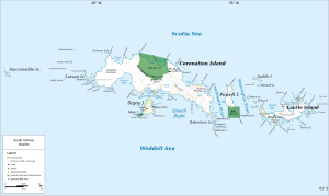
| Map of the South Orkney Islands including the Larsen Islands | ||
| Waters | Southern ocean | |
| Geographical location | 60 ° 36 ′ S , 46 ° 4 ′ W | |
|
|
||
| Main island | Monroe Island | |
| Total land area | at least 1805 ha | |
| Residents | uninhabited | |
The Larsen Islands are a small group of islands within the archipelago of the Southern Orkney Islands in the Southern Ocean about 1300 km southeast of the coast of Argentina and 600 km northeast of the Antarctic Peninsula . You are just within the territory protected by the Antarctic Treaty . The largest island in the group is Monroe Island , about 10 km from Coronation .
history
The Larsen Islands were discovered in December 1821 by George Powell (1794-1824) and Nathaniel Palmer . The Norwegian captain Petter Sørlle (1884-1933) named the islands after the whaler and Antarctic explorer Carl Anton Larsen during a voyage in 1912 and 1913 on the occasion of the survey of the southern Orkney Islands .
In 2011, BirdLife International declared 1805 hectares of the islands an important breeding ground for sea birds . In 2010, 125,000 pairs of chinstrap penguins and 125,000 pairs of silver petrels and a smaller number of pairs of snow petrels were breeding in the Larsen Islands .
literature
- Kenneth J. Bertrand, Fred G. Alberts, Meredith F. Burrill: Geographic names of Antarctica official standard names approved by the United States Board Board on Geographic Names. (= Gazetteer. - United States Board on Geographic Names, No. 14, p. 216.) Office of Geography, Washington (DC) 1956, OCLC 251691612 , p. 188.
Individual evidence
- ↑ Monroe Island on data.aad.gov.au, accessed on January 9, 2014 (English).
- ^ Moreton Point, Monroe Island and Larsen Islands, western Coronation Island. BirdLife International, accessed January 8, 2014 .

