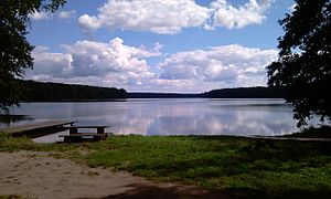
Liebausee
|
Jezioro Lubowo Liebausee |
|
|---|---|

|
|
| Liebausee, bathing area on the north bank | |
| Geographical location | Strzelecko-Drezdenecki District , Lubusz Voivodeship , Poland |
| Tributaries | Lubiathfließ |
| Drain | Lubiathfließ |
| Location close to the shore | Drezdenko |
| Data | |
| Coordinates | 52 ° 45 '1 " N , 15 ° 49' 14" E |
| Altitude above sea level | 35.1 m above sea level NHN |
| surface | 15.2 km² |
| volume | 4.0527 million m³ |
| Maximum depth | 8.0 m |
| Middle deep | 4.0 m |
The Liebausee , in Polish Jezioro Lubowo , is a lake in the Netzer Heide in the Lubusz Voivodeship in Poland.
geography
The Liebausee is about ten kilometers south of the town of Drezdenko ( Driesen ) and two kilometers west of the village of Grotów ( Modderwiese ). It is crossed by the Lubiathfließ ( Lubiatka ) drainage canal .
Naming
The official Polish name of the lake is Jezioro Lubowo . However, the name Jezioro Morawy is sometimes used in official publications . The name Jezioro Lubiatowskie is common in the area around the lake .
use
Todays use
The lake is a recreational area for the town of Drezdenko and the villages in the surrounding area. On the north-western bank is a scout camp used in summer.
Previous use
Until the end of the war, the Liebausee served as a backwater basin in the drainage system of the Netzbruch. Connected to the Netze ( Noteć ) via the Lubiath river, the weir on the north-western bank could be closed during floods, the flowing water of the Lubiath river then flooded the flat forest areas on the southern bank. A small power station was also operated at the weir; the electricity generated was then used by a sawmill, the grounds of which are now occupied by the scout camp.
Footnotes
- ↑ a b c d gorzow.pios.gov.pl
