Lubiathfließ
|
Lubiathfließ (Polish Lubiatka) |
||
|
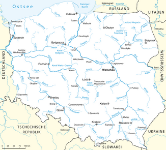
Location of the networks in the Polish river system |
||
| Data | ||
| location | Lebus | |
| River system | Or | |
| Drain over | Networks → Warta → Oder → Baltic Sea | |
| source | south of Modderwiese (Grotów) 52 ° 27 ′ 1 ″ N , 15 ° 31 ′ 14 ″ E |
|
| muzzle | at Brenkenhofsbruch (Błotno) in the network coordinates: 52 ° 28 ′ 19 ″ N , 15 ° 25 ′ 13 ″ E 52 ° 28 ′ 19 ″ N , 15 ° 25 ′ 13 ″ E
|
|
| length | 17 km | |
| Catchment area | 17,240 km² | |
| Flowing lakes | Liebausee (Jezioro Lubowo) | |
|
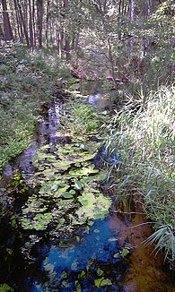
The Lubiathfließ at the old railway embankment in Trebitscher Tangier |
||
The Lubiathfließ, in Polish Lubiatka , is a drainage canal in Poland, in the Lubusz Voivodeship. It flows through the rural community of Driesen (Drezdenko) over a length of 17 km.
course
The origin of the Lubiath river lies in the village of Modderwiese (Grotów). It flows through the Liebausee, where after about 1 km it receives a tributary from the Klitzingsee, another west of the village of Eschbruch (Rąpin). Then it crosses under the disused railway line Schwerin ( Skwierzyna ) - Driesen (Drezdenko) west of the hamlet Trebitscher Tanger (Trzebickie Niwy) as well as in the village Trebitschermühle (Trzebicz Młyn) the voivodship road 158. It then flows through the Malisks west of Sieb (Bagniewo) Netzeauen and flows into the nets opposite Brenkenhofsbruch (Błotno) . To the north of the village of Gottschimm (Gościm), approx. 500 m before the mouth, there is a 4 km long backflow canal that connects the Lubiath river with the Gottschimmer mill river.
history
The Lubiath flow was created around 1766 as part of the reclamation of the Netzbruch, led by Franz Balthasar Schönberg von Brenkenhoff . To this day, it still guides the groundwater south-west of the city of Driesen into the network. Several weirs were built along the river, including the outflow from the Liebausee , in the hamlet of Lubiathfließ, on the old embankment west of the Trebitscher Tangers, and in Trebitschermühle. Of these, only the weir in the hamlet of Lubiathfließ is preserved today, of the others only remains are left. The Lubiathfließ had a further tributary with the Mühlenfließ from the Rumpiner See . The weir on the western end of the lake was torn down after the war to extract bricks, and the course of the former mill river between the Rumpinsee and the bed of the Lubiath river is now a natural swampy landscape again. The original course of the Lubiath flow was led into the Trebitscher Mühlenfließ in the mid-30s in order to increase the flow rate in favor of the mills in Trebitscher Mühle. For this purpose, a connecting canal was dug west of Eschbruch, which continued to use the bed of the Trebitsch mill flow shortly before the embankment of the Schwerin - Driesen line. The old bed of the canal (Stiller Lauf) between Eschbruch and Sieb still exists, today under the name Suchy Rów, and serves as a backwater canal during floods.
Previous use
A water mill was operated in the village of Trebitschermühle until the end of the war. Remains of the mill are still there today. In the hamlet of Lubiathfließ, fish was farmed in a reservoir in front of the weir. This facility still exists.
The weirs at Liebausee and Rumpiner See were used in spring to flush the mud out of the lakes to prevent silting up and to support fishing.
Small power plants for generating electricity were installed at all three weirs at the beginning of the 1930s. The electricity generated at the end of the Liebauseee was used by a sawmill, which was demolished in 1965. Today there is a scout camp on its premises. The electricity generated in Trebitscher Mühle was used to pump water through a pipe under the dam of the Driesen - Lipke road into the flat forests behind it when the Maliskenwiesen were flooded.
nature
A large number of rare animal and plant species have resettled along the Lubiath River, including white-tailed eagles, black storks, gray herons, kingfisher and beaver.

