
List of cultural monuments in Borken (Hessen)
Borken (Hesse)

The following list contains the cultural monuments identified in the monument topography in the area of the city of Borken , Schwalm-Eder-Kreis , Hesse .
- Note: The order of the monuments in this list is based first on the city district and then on the address; alternatively, it can also be sorted by name or construction time.
The basis is the publication of the Hessian list of monuments, which was created for the first time on the basis of the Monument Protection Act of September 5, 1986 and has been continuously updated since then.
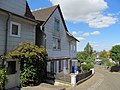
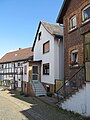
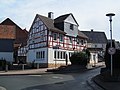
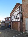
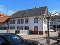
Complete system Borken I
| image | designation | location | description | construction time | Data |
|---|---|---|---|---|---|
| The entire complex includes the historic city center in its medieval extension. Am Alten Hof 1–15; At the district court 1–9, 2–4; At church 1–2; Bahnhofstrasse 63–79, 83–89, 86–110; Iron chews 11-13, 2-6; Hintergasse 1-11, 2-18, 22-32; Kirchstrasse 1–3; Marketplace 3, 11–15; Marktstrasse 15–17, 2–16; Obere Bergstrasse 3–17, 2–10, 14–22; Untere Bergstrasse 1–7, 2–6; Moat 7. (g) | |||||
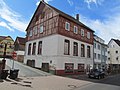
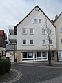
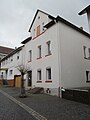
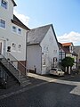
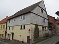
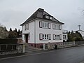
| A house | Am Alten Hof 13, location hall: 11, parcel: 148 |
(g, s) | 1850 | ||
 |
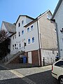
Old district court | The District Court 2 Location Village: 11, parcel 60 |
(g, s, w) | 1473 | |
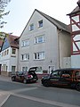
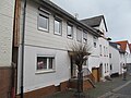
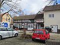
| three-zone stable house | The District Court 5 Location Village: 11, parcel: 45/2 |
(g, s) | last quarter of the 18th century | ||
 |
Protestant town church | At the church one location hall: 11, parcel 40 |
(g, k, s) | 1845 | |
 |
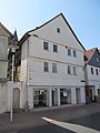
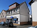
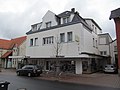
Residential and commercial building | Bahnhofstraße 69 Location hall: 11, parcel: 6/5 |
(g, s) | 1830 | |
 |
Residential stable house | Bahnhofstraße 79 Location floor: 11, parcel: 259/11 |
(g, s) | Late 18th century | |
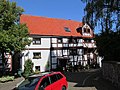
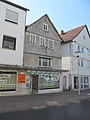
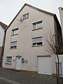
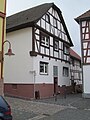
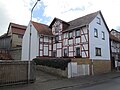
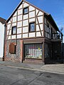
| Half-timbered building | Bahnhofstraße 96 Location hall: 11, parcel: 35/2 |
(g, s) | 1767 | ||
 |
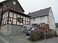
Half-timbered house | Bahnhofstraße 98 Location hall: 11, parcel: 33/2 |
(g, k, s) | 1700 | |
 |
Town hall, school, Jewish school | Hintergasse 1 position corridor 11, plot 75 |
(g, s) | 1469 | |
 |
Ernhaus | Behind gate 14 position corridor 11, plot 98 |
(g, s) | in the middle of the 19th century | |
 |
gable-independent single house | Hintergasse 18, location hall: 11, parcel: 115 |
(g, s) | first half of the 19th century | |
 |
Eaves half-timbered house | Hintergasse 24 position corridor 11, plot: 119/2 |
(g, k, s) | 1700 | |
 |
Half-timbered house | Hintergasse 32, location hall: 11, parcel: 126 |
(g, s) | early 18th century | |
 |
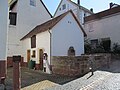
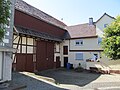
Courtyard | Kirchstraße 11 Location floor: 11, parcel: 62/1 |
(g, s) | around 1900 | |
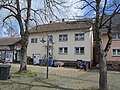
| Farm buildings | Kirchstraße 15 Location floor: 11, parcel: 62/2 |
(g, s) | second half of the 19th century | ||
 |
town hall | Marktstraße 3 Location hall: 11, parcel: 79/1 |
(g, k, s, w) | 1611 | |
 |
Residential building | Marktstraße 2 Location floor: 11, parcel: 78 |
(s) | ||
 |
Half-timbered house | Marktstraße 4 Location floor: 11, parcel: 77 |
(g, s) | 1823 | |
 |
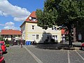
Half-timbered house | Marktstraße 6 Location floor: 11, parcel: 76 |
(s) | second half of the 19th century | |
 |
Fountain | Marktstraße 6 Location floor: 11, parcel: 76 |
(G) | ||
 |
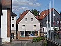
A house | Marktstraße 14/16 Location floor: 11, parcel: 69 |
(g, s) | mid 19th century | |
 |
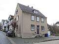
eaves single house | Obere Bergstrasse 14, corridor location : 11, parcel: 135/1 |
(g, s) | around 1860 | |
 |
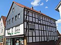
Half-timbered building | Obere Bergstraße 22 Location floor: 11, parcel: 142 |
(g, s) | mid 18th century | |
 |
Half-timbered building | Untere Bergstraße 2 Location hall: 11, parcel: 61 |
(g, s) | second half of the 18th century | |
| Half-timbered house | Untere Bergstrasse 4 position corridor 11, plot 64 |
(g, s) | early 18th century | ||
 |
barn | Untere Bergstrasse 4 position corridor 11, plot 64 |
(G) | second half of the 19th century |
- Monuments of the entire complex I without their own entry in the topography
At the church 2
At the church 3
Bahnhofstrasse 75
Bahnhofstrasse 77

Bahnhofstrasse 86

Bahnhofstrasse 88
Bahnhofstrasse 94
Bahnhofstrasse 100

Bahnhofstrasse 102
Bahnhofstrasse 104
Bahnhofstrasse 106

Bahnhofstrasse 108

Iron chews 2
Back alley 2

Back alley 3
Back alley 5
Back alley 6
Back alley 9
Back alley 10
Back alley 12
Back alley 16

Back alley 20
Back alley 22
Back alley 26
Back alley 28

Back alley 30
Marktstrasse 8

Marktstrasse 10
Marktstrasse 12
Marktstrasse 15
Marktstrasse 17

Obere Bergstrasse 2
Obere Bergstrasse 10
Obere Bergstrasse 15
Obere Bergstrasse 17
Obere Bergstrasse 20

Untere Bergstrasse 6


Complete facility Borken II
| image | designation | location | description | construction time | Data |
|---|---|---|---|---|---|
| Horse drink | Horse drinks 1-27; 6-14. (G) | ||||
 |
large volume building | Pferdetränke 1 position corridor 11, plot 86 |
(g, s) | in the middle of the 19th century | |
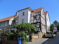
 |
three-zone half-timbered house | Pferdetränke 9 position corridor 11, parcel: 235/95 |
(g, s) | first half of the 19th century | |
 |
Half-timbered house | Horse troughs 10 Corridor location : 12, parcel: 24/2 |
(s) | around 1900 | |
 |
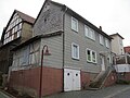
jewish school | Horse troughs 12 Corridor location : 12, parcel: 28/5 |
(g, s) | 1895/96 | |
 |
three-sided courtyard | Pferdetränke 14 position corridor 12, plot 29 |
(g, s) | 1911 | |
 |
barn | Pferdetränke 14 position corridor 12, plot 29 |
(g, s) | last quarter of the 19th century | |
 |
Half-timbered house | Horse troughs 21 Location hall: 11, parcel: 102/1 |
(g, s) | early 19th century | |
 |
former public house | Horse troughs 25 Location hall: 11, parcel: 100 |
(g, s) | ||
 |
eaves permanent stable house | Horse troughs 27 Location hall: 11, parcel: 106 |
(g, s) |
- Monuments without their own entry in the topography
Horse drink 5
Horse drink 6

Horse drink 7
Horse drink 8

Horse drink 11
Horse drink 13
Horse drink 15

Horse drink 17

Horse drink 19

Horse drink 23


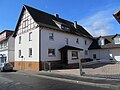
Entire facility Borken III
| image | designation | location | description | construction time | Data |
|---|---|---|---|---|---|
| City expansion in front of Herboldshäuser / Neustädter Tor along Bahnhofstrasse | Altenburgstrasse 1–5, 4–8; Bahnhofstrasse 43–59, 52–84; Horse drink 4. (g) | ||||
 |
Residential stable house | Altenburgstraße 3 Location hall: 12, parcel: 46/1 |
(g, s) | second half of the 18th century | |
 |
Residential stable house | Altenburgstraße 5 Location hall: 12, parcel: 47 |
(G) | Beginning of the 19th century | |
 |
two-storey half-timbered house | Bahnhofstraße 45 Location floor: 12, parcel: 3/12 |
(g, k, s) | around 1700 | |
| gable-independent two-storey half-timbered house | Bahnhofstraße 52 Location hall: 12, parcel: 57/1 |
(g, s) | 1823 | ||
 |
Half-timbered construction | Bahnhofstraße 55 Location hallway: 12, parcel: 12/1 |
(g, s) | early 18th century | |
 |
Half-timbered building | Bahnhofstraße 57 Location hallway: 12, parcel: 14/1 |
(s) | in the early 19th century | |
 |
Half-timbered house | Bahnhofstraße 59 Location hallway: 12, parcel: 15/7 |
(g, s) | second half of the 18th century | |
| Half-timbered construction | Bahnhofstraße 76 Location hall: 12, parcel: 42 |
(g, s) | 1796 |
- Monuments of the entire complex III without their own entry in the topography

Altenburgstrasse 1

Altenburgstrasse 4
Altenburgstrasse 6
Bahnhofstrasse 43
Bahnhofstrasse 45a

Bahnhofstrasse 47
Bahnhofstrasse 51
Bahnhofstrasse 53

Bahnhofstrasse 84
Horse drink 4


Entire plant Borken IV
| image | designation | location | description | construction time | Data |
|---|---|---|---|---|---|
| the area of the northwestern Bahnhofstrasse and the area around the town hall | Am Rathaus 7, 7a; Bahnhofstrasse 25–31, 16–32; Dr.-Eckener-Strasse 1–3, 2–6; Europaplatz 1; Zeppelinstrasse 2-6. (G) | ||||
 |
former mansion | Am Rathaus 7 position hall: 9, parcel: 9/127 |
(g, k, s) | 1922/23 | |
 |
urban residential building | Zeppelinstraße 2 Location hall: 9, parcel: 16/8 |
(g, s) | 1930s | |
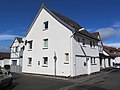
 |
Duplex house | Zeppelinstraße 4/6, location floor: 9, parcel: 16/28 and 16/27 |
(g, s) | around 1930 |
- Monuments of the entire complex IV without their own entry in the topography
Bahnhofstrasse 27

Bahnhofstrasse 29
Dr.-Eckener-Strasse 1
Dr.-Eckener-Strasse 2
Dr.-Eckener-Strasse 3
Dr.-Eckener-Strasse 4
Dr.-Eckener-Strasse 6
Europaplatz 1


Complete system Borken V
| image | designation | location | description | construction time | Data |
|---|---|---|---|---|---|
| Development on Bobenhäuser Weg | Bahnhofstrasse 12; Bobenhäuser Weg 1–23, 12–16. (G) | ||||
 |
Residential building | Bahnhofstraße 12 Location hallway: 9, parcel: 31/3 |
(g, s) | around 1920 |
Complete system Borken VI
| image | designation | location | description | construction time | Data |
|---|---|---|---|---|---|
| the workers' housing estate belonging to the power plant | At the power station 1–19. (G) |
Individual monuments
| image | designation | location | description | construction time | Data |
|---|---|---|---|---|---|
| villa | Bahnhofstraße 34 Location hall: 12, parcel: 66/9 |
(G) | 1904 | ||
 |
Streckhof | Bahnhofstraße 44 Location hall: 12, parcel: 63/5 |
(g, s) | from 1720 | |
 |
Residential building | Gellenweg 2 position corridor 12, parcel: 521/70 |
(g, s) | in the beginning of the 20th century | |
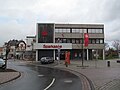
 |
school | Geysostraße 2 position hallway: 3, parcel: 100/8 |
(g, s) | 1907 | |
| Water tower | Kellerwaldstraße location hall: 7, parcel: 96/6 |
(g, s) | 1969-71 | ||
 |
Duplex | Krausgasse 44/46 location floor: 10, parcel: 28/1 and 116/29 |
(g, s) | Early 20th century | |
 |
Single family home | Krausgasse 48 Location hall: 10, parcel: 118/30 |
(g, s) | in the beginning of the 20th century | |
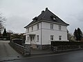
| Single family home | Singliser Straße 6 Location hall: 7, parcel: 50/12 |
(G) | late 20s | ||
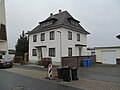
| Single family home | Singliser Straße 7 Location hall: 3, parcel: 44/1 |
(G) | Mid-1920s | ||
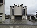
 |
Aggregate power plant | The old power plant 2 Location Village: 2 Parcel: 32/176 |
(g, s, t) | 1923-29 |
List of cultural monuments in Trockenerfurth
| image | designation | location | description | construction time | Data |
|---|---|---|---|---|---|
 |
Courtyard | At the Wiegebunnen 1 position hall: 5, parcel: 24/1 |
(g, k, s) | 1680 | |
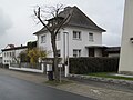
 |
Residential building | At the Lichte 6 location hall: 5, parcel: 28 |
(g, s) | first quarter of the 19th century | |
| small courtyard | Bodenweg 2 position hallway: 7, parcel: 22/5 |
(G) | late 19th century | ||
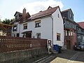
 |
House in a courtyard | Hardtstraße 3 Location hallway: 5, parcel: 64/18 |
(g, w) | late 16th or early 17th century | |
 |
stately home | Hardtstraße 10 Location floor: 5, parcel: 114/3 |
(g, s) | second half of the 19th century | |
 |
Protestant church | Hardtstrasse 17 location |
(g, k, s) | 1555 | |
| House in a courtyard | Hardtstraße 18 Location floor: 6, parcel: 27/6 |
(g, s) | around 1900 | ||
| Barn in a courtyard | Hardtstrasse 19 location |
(G) | 1726 | ||
| Residential house with adjoining stable | Hardtstrasse 23 location |
(g, s) | second half of the 19th century | ||
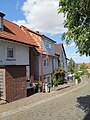
 |
Streckhof | Hirtenplatz 2 Location hall: 5, parcel: 22/3 |
(g, s) | Beginning of the 19th century | |
| House in a courtyard | Lohwiesenweg 6 Location hallway: 3, parcel: 46/3 |
(G) | Beginning of the 20th century | ||
| Two-family house (Steigerhaus) | Lohwiesenweg 11/13 Location hallway: 3, parcel: 64/24 and 64/15 |
(g, s) | Mid-1920s | ||
| Semi-detached house (Steigerhaus) | Lohwiesenweg 15/17 Location floor: 3, parcel: 64/26 and 64/19 |
(g, s) | Mid-1920s | ||
 |
detached house | Talstraße 4 Location hallway: 5, parcel: 44/4 |
(g, k, s) | Early 18th century | |
| War memorial | Römersbergstraße location floor: 7, parcel: 18/3 |
(G) | 1958 | ||
 |
The whole of the workers' settlement | Wildunger Straße 3–25 Location corridor: 2, parcel: 11/11, 11/12, 11/13, 11/14, 11/15, 11/16, 11/17, 11/18, 11/19, 11 / 20, 11/21 and 11/22 |
(g, s) | from 1922 |
Remarks
- ↑ referred to as Marktplatz 11 in the monument topography
- ↑ referred to as Marktplatz 15 in the monument topography
- ↑ referred to as Marktplatz 3 in the monument topography
Web links
Cities and municipalities in Schwalm-Eder-Kreis: Bad Arolsen | Bark | Edermünde | Felsberg | Frielendorf | Fritzlar | Gilserberg | Gudensberg | Guxhagen | Homberg | Jesberg | Knüllwald | Körle | Malsfeld | Melsungen | rotten | Neuental | Neukirchen | Niedenstein | Oberaula | Ottrau | Schrecksbach | Schwalmstadt | Schwarzenborn (Knüll) | Spangenberg | Wabern (Hessen) | Willingshausen