
List of cultural monuments in Lohfelden
The list of cultural monuments in Lohfelden contains all cultural monuments in Lohfelden .
Legend
- Name: gives the name, the description or the type of the cultural monument.
- Location: States the street name and, if available, the house number of the cultural monument. The list is basically sorted according to this address. The link "Map" leads to various map displays and gives the coordinates of the cultural monument.
- Dating: indicates the date; the year of completion or the period of construction. Sorting by year is possible.
- Description: Provides structural and historical details of the cultural monument, preferably the characteristics of the monument.
- Object no .: If available, indicates the object ID of the cultural monument assigned by the State Office for Monument Preservation.
Crumbach
Complete complex I historical town center
| image | designation | location | description | construction time | Data |
|---|---|---|---|---|---|
| Bachstrasse 5, 9, 11, 19–31, 22–30, 36–40; Brückenstrasse 1–11, 2–6; Crumbacher Strasse 51-71, 75-83, 91, 93, 97, 30-48; Routes 1–3, 2–8; In the old pond 1–5; Jahnstrasse 1–2; Kirchweg 1–7, 2–14; Mittelstrasse 1, 2-8; Spangenberger Path 1–3, 2; Stichelweg 1–9, 10–16; Vorsterstrasse 1–5, 6; Wälzebachstrasse 1–7, 2–6. | |||||
 |
Open space on the former outskirts |
Corridor location : 2, parcel: 85/5, 87/2, 88/1, 348/1, 349/2, 672/351, 352/2, 355/6, 364/1, 364/2 |
|||
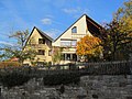
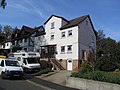
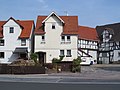
 |
two-story brick building | Bachstraße 21 Location hallway: 2, parcel: 268/2 |
(g, k) | from the early 20th century | |
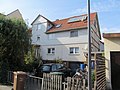
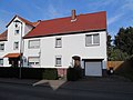
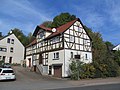
 |
A house | Bachstraße 38 Location floor: 2, parcel: 196/3 |
(g, s) | late 18th century | |
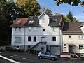
 |
Farm building in a courtyard | Jahnstraße 2 Location floor: 2, parcel: 6/11 |
(g, s) | ||
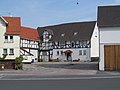
 |
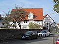
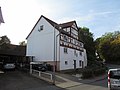
Protestant church | Kirchweg 5 Location hallway: 2, parcel: 287 |
(g, k, s, w) | before 1770 | |
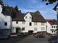
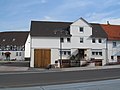
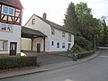
 |
former restaurant | Mittelstrasse 1 position hallway: 2, plot: 265/1 |
(g, s) | Early 20th century |
- Monuments of the entire complex I Historic town center without its own entry in the topography ("ensemble protection")

Bachstrasse 23
Bachstrasse 25

Bachstrasse 29
Bachstrasse 31

Bachstrasse 40

Brückenstrasse 9
Bruckenstrasse 11

Route 1

In the old pond 1

In the old pond 3
In the old pond 5

Jahnstrasse 1

Mittelstrasse 8


Vollmarshausen
Complete system of the historic town center
| image | designation | location | description | construction time | Data |
|---|---|---|---|---|---|
| Brunnenstrasse 1, 1a, 1b, 1c, 5–31, 35, 2–10; Trench 2-12; Hintergasse 1-9, 2-34; Kasseler Strasse 1, 1a, 3–9, 13–17, 29–33, 2–8, 14–16; Kaufunger Strasse 1–3, 2–4; Kirchgasse 1-5; Sellestrasse 1-11; Vollmarshäuser Strasse 1–23, 2–14; Welleröder Strasse 1–7, 4–26 | |||||
 |
Right residential building in a three-sided courtyard | Brunnenstrasse 1 position hallway: 7, parcel: 78/1 |
(g, s) | 1682 | |
 |
left residential building of a three-sided courtyard | Brunnenstraße 1b Location hall: 7, parcel: 78/1 |
(g, s) | Early 20th century | |
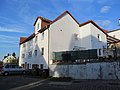
 |
Town hall and hose tower | Brunnenstraße 4 Location hall: 7, parcel: 86/13 |
(g, s) | Late 18th or early 19th century | |
 |
A house | Brunnenstraße 11 Location hall: 7, parcel: 64/1 |
(g, s) | second half of the 18th century | |
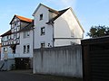
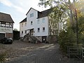
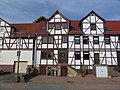
 |
Former harvest house with stable and storage building on one side | Behind gate 14 position hallway: 7, parcel: 410 |
(g, s) | 1816 | |
 |
Apartment building | Kasseler Straße 3 Location hall: 7, parcel: 354/2 |
(g, s) | in the middle of the 19th century | |
| gable-independent Ernhaus | Kasseler Straße 4 Location floor: 7, parcel: 351/3 |
(g, s) | last third of the 18th century | ||
 |
Eaves house | Kasseler Straße 5 Location hall: 7, parcel: 349/5 |
Villa Elisabeth , classicist residential and administrative building of a former company behind it. | 1825 | |
 |
Barn of an L-shaped yard | Kasseler Straße 15 Location hall: 7, parcel: 303/5 |
(G) | 1808 | |
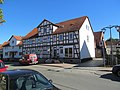
 |
Half-timbered house | Kaufunger Straße 3 Location hall: 7, parcel: 337/4 |
(g, s) | first half of the 19th century | |
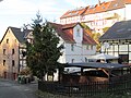
 |
Full Marshals Church | Vollmarshäuser Straße 4 Location hall: 7, parcel: 74/3 and 74/7 |
Evangelical Church in Vollmarshausen | 1838 | |
| Churchyard of the Vollmarshausen Church | Vollmarshäuser Straße 4 Location hall: 7, parcel: 74/3 |
(g, s) | |||
 |
Sloping garden of a former parish homestead | Kirchgasse location hall: 7, parcel: 76 |
(g, s) | ||
 |
A house | Selle 1 location hall: 7, parcel: 310/1 |
(g, s) | 1781 | |
 |
Ernhaus | Selle 3 location hall: 7, parcel: 313/1 |
(g, s) | Mid 18th century | |
 |
Selle 11 location hall: 7, parcel: 324/3 |
||||
 |
Half-timbered barn | Vollmar Straße 2 Location Village: 7, parcel: 78/1 |
(g, s) | in the first half of the 19th century | |
 |
Ernhaus with utility wing | Vollmarshäuser Straße 5 Location hall: 7, parcel: 21/6 |
(g, s) | in the second half of the 18th century | |
 |
Ernhaus | Welleröder Straße 5 Location hallway: 7, parcel: 128/4 |
(g, s) | first half of the 18th century | |
 |
Ernhaus | Welleröder Straße 22 Location floor: 7, parcel: 43/9 |
(g, s) | late 18th century | |
 |
Residential building, barn and stable of a three-sided courtyard, including the courtyard paving | Welleröder Straße 24 Location floor: 7, parcel: 47/6 |
(g, s) | from the late 18th century | |
 |
House, barn as well as stable and storage building | Welleröder Straße 26 Location floor: 7, parcel: 48/7 |
(g, s) | 1791 |
- Monuments of the entire complex of the historic town center without their own entry in the topography ("ensemble protection")
Brunnenstrasse 7

Brunnenstrasse 13

Brunnenstrasse 13a

Dig 2
Dig 4

Dig 6

Trench 8a and 8
Trench 10a and 10
Dig 12

Back alley 3
Back alley 7
Back alley 16

Back alley 22

Back alley 24

Back alley 30

Back alley 32

Back alley 34
Kasseler Strasse 6

Kasseler Strasse 7

Kasseler Strasse 8
Kasseler Strasse 9

Kasseler Strasse 13
Kasseler Strasse 14
Kasseler Strasse 15
Kasseler Strasse 16

Kasseler Strasse 17

Kaufunger Strasse 1a

Vollmarshäuser Strasse 2
Vollmarshäuser Strasse 6

Vollmarshäuser Strasse 8

Vollmarshäuser Strasse 10

Vollmarshäuser Strasse 12

Vollmarshäuser Strasse 14

Vollmarshäuser Strasse 17

Vollmarshäuser Strasse 19
Vollmarshäuser Strasse 21
Vollmarshäuser Strasse 23
Welleröder Strasse 4

Welleröder Strasse 6

Welleröder Strasse 7

Welleröder Strasse 8
Welleröder Strasse 10

Welleröder Strasse 12

Welleröder Strasse 14
Welleröder Strasse 16

Welleröder Strasse 18


Individual monuments
| image | designation | location | description | construction time | Data |
|---|---|---|---|---|---|
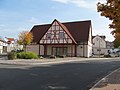
 |
three-story residential building | Kaufunger Straße 9 Location hall: 7, parcel: 326/6 |
(g, k) | late 19th century | |
 |
two-story brick school | Kaufunger Straße 20 Location floor: 7, parcel: 67/28 |
(g, k) | 1894 | |
| former farm building | Welleröder Straße 27 Location floor: 7, parcel: 105/1 |
(G) | first half of the 19th century | ||
| Obermühle | Welleröder Straße 42 Location floor: 7, parcel: 63/5 |
(G) | First mentioned in a document in 1308 |
Towns and municipalities in the Kassel district: Ahnatal ( Heckershausen | Weimar ) | Bad Emstal | Bad Karlshafen ( Bad Karlshafen | Helmarshausen ) | Baunatal ( Altenbauna | Altenritte | Großenritte | Guntershausen | Hertingshausen | Kirchbauna | Rengershausen ) | Breuna | Calden | Espenau | Fuldabrück ( Bergshausen | Dennhausen | Dittershausen | Dörnhagen ) | Fulda Valley | Grebenstein | Habichtswald | Helsa | Hofgeismar | Habichtswald | Immenhausen | Kaufungen | Liebenau | Lohfelden | Naumburg | Nieste | Niestetal | Reinhardshagen ( Vaake | Veckerhagen ) | Schauenburg | Söhrewald | Trendelburg | Vellmar | Wesertal ( Arenborn | Gewissenruh | Gieselwerder | Gottstreu | Heisebeck | Lippoldsberg | Oedelsheim | Vernawahlshausen ) | Wolfhagen | Zierenberg