List of natural monuments in Coppenbrügge
The list of natural monuments in Coppenbrügge names the natural monuments in Coppenbrügge in the Hameln-Pyrmont district in Lower Saxony .
Natural monuments
| number | designation | Place, location | description | Protective reason | image
|
|---|---|---|---|---|---|
| ND-HM 028 | Devil's Kitchen in the Ith |
Coppenbrügge ( 52 ° 6 ′ 26.1 ″ N , 9 ° 32 ′ 9.6 ″ E ) |
Landslide. The "Teufelsküche" is a rock basin divided by stone blocks at the foot of the Fahnenstein massif on the northern Ith slope south of Coppenbrügge. The rock basin was created by the weathering of the corallenoolite and is of particular importance as a Germanic cult site and for the Pied Piper legend. | Character and beauty, regional and scientific importance | |
| ND-HM 029 | Flagstone in the Ith |
Coppenbrügge ( 52 ° 6 ′ 25.4 ″ N , 9 ° 32 ′ 11.5 ″ E ) |
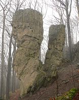
The "flag stone" is located on the northeast corner of the Oberberg south of Coppenbrügge and stands out clearly from the ridge of the northern Ith as a striking, approx. 15 m high corallenoolith cliff. The rock cliff is a nationally known vantage point. | Character and beauty, scientific importance | |
| ND-HM 030 | Rocking stone in the Ith |
Coppenbrügge ( 52 ° 6 ′ 28.1 ″ N , 9 ° 31 ′ 59.2 ″ E ) |
The "Wackelstein" is located on the northern slope of the upper mountain in the forest of the northern Ith. The "rocking stone" is a movable dolomite plate lying on an inclined rock base, which has been preserved as a special feature of the weathering of the rock. The rocking stone has a special meaning as a Germanic place of worship. | Rarity, peculiarity and beauty, scientific and local significance | |
| ND-HM 031 | Falkenstein in the Ith |
Coppenbrügge ( 52 ° 6 ′ 23 ″ N , 9 ° 31 ′ 55.5 ″ E ) |
The “Falkenstein” is an approx. 20 m high, compact, free-standing rock cliff made of coral oolite, which rises from the ridge of the northern Ith at the northwest corner of the Oberbergkamm. | Character and beauty, scientific importance | |
| ND-HM 032 | Adam and Eve in the Ith |
Bessingen ( 52 ° 6 ′ 11.5 ″ N , 9 ° 31 ′ 42.2 ″ E ) |
The rock group "Adam and Eve" consists of two free-standing, column-shaped rock cliffs approx. 15 m high, which were created in the course of the weathering of the coral oolite. The rock group is located below the Ith ridge in the northern part of the so-called Bessinger cliffs. The rock group "Adam and Eve" is known nationwide as a tourist attraction. | Character and beauty, scientific and local significance |

|
| ND-HM 033 | Peter-Linde Castle Coppenbrügge |
Coppenbrügge ( 52 ° 7 ′ 5,6 ″ N , 9 ° 32 ′ 48 ″ E ) |
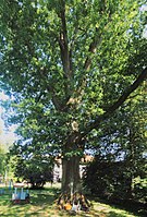
The "Peter-Linde" (Tilia ssp.) Stands on the rampart of the Coppenbrügge castle and was planted around 500–700 years ago. In honor of a visit by Tsar Peter the Great in 1697, the tree was named Peter Linden. The "Peter-Linde" stands on a stone walled wall and has a wide, bizarre growth, structured by mighty strong branches. | regional significance |
 more pictures |
| ND-HM 150 | Mönchstein in the Ith |
Bisperode ( 52 ° 5 ′ 42.7 ″ N , 9 ° 31 ′ 13.3 ″ E ) |
The "Mönchstein" is an approx. 20 m high massive rock cliff in the north of Ith, which stands out from the so-called Bessinger cliffs. The rocky cliff made of corallenoolite has an upstream block rubble and is a result of natural limestone weathering. | Character and beauty, scientific importance | |
| ND-HM 151 | Sulfur well in Bessingen |
Bessingen ( 52 ° 6 ′ 16.5 ″ N , 9 ° 30 ′ 17 ″ E ) |
The “sulfur fountain” is a contained spring area in the local area of Bessingen with the discharge of water with a high concentration of sulfur. Some of the water is used by the villagers for healing purposes. | Rarity, scientific importance |

|
| ND-HM 152 | Oak at the Harderoder Mühle |
Harderode ( 52 ° 2 ′ 20.3 ″ N , 9 ° 32 ′ 36.2 ″ E ) |
The pedunculate oak (Quercus robur) is found in the wood on the banks of the river “Ilse” on the southern outskirts of Harderode. The large-crowned tree shows a typical growth and has a special meaning for the landscape. | beauty | |
| ND-HM 153 | Grove of trees on the Harderoder Pfingstanger |
Harderode ( 52 ° 2 ′ 57.8 ″ N , 9 ° 32 ′ 10.9 ″ E ) |
The group of trees that characterize the landscape is located on the Pfingstanger, which is used as a fairground, on the northern outskirts of Harderode and consists of 6 large-crowned oaks (Quercus robur) and 5 linden trees (Tilia spp.). Cultural and historical significance as a thing place (court / assembly place). | Beauty, local significance | |
| ND-HM 182 | Hornbeams at the Mittelmühle |
Coppenbrügge ( 52 ° 7 ′ 37.2 ″ N , 9 ° 32 ′ 34.1 ″ E ) |
The two old hornbeams (Carpinus betulus) stand on a fallow, bushy slope edge north of the Mittelmühle in the district of Coppenbrügge. The compact, closed treetops stand out clearly from the wooded contours of the surrounding area. Significance for the landscape. | beauty | |
| ND-HM 183 | Hudebäum near Harderode |
Harderode ( 52 ° 3 ′ 19.3 ″ N , 9 ° 32 ′ 50.3 ″ E ) |
The group of trees is located northeast of Harderode on a slope meadow on the Ith. The group of trees consists of two linden trees (Tilia cordata) and a pedunculate oak (Quercus robur) and offers protection to grazing cattle with the closed, wide canopy. Significance for the landscape. | Beauty, local significance | |
| ND-HM 184 | Red oak in the old forest house garden in Coppenbrügge |
Coppenbrügge ( 52 ° 7 ′ 5.5 ″ N , 9 ° 32 ′ 48.4 ″ E ) |
The red oak (Quercus rubra) stands in the spacious garden of the former forester's house, now a kindergarten in Coppenbrügge, southwest of the castle near the moat. The tree has a typical, compact, powerful growth and, due to its dominance, is important for the townscape. | Rarity and beauty |

|
| ND-HM 185 | Hude oak in the Harderode district |
Harderode ( 52 ° 3 ′ 16.9 ″ N , 9 ° 32 ′ 40.1 ″ E ) |
The Hude oak (Quercus robur) stands on an abandoned orchard meadow on the Ith north of Harderode. The tree is part of the richly structured cultural-historical pasture landscape of the shallow, dry Ith slope. Significance for the landscape. | Beauty, local significance | |
| ND-HM 186 | Chestnut in Hohnsen |
Hohnsen ( 52 ° 8 ′ 42.3 ″ N , 9 ° 28 ′ 47.4 ″ E ) |
The chestnut (Aesculus hippocastanum) stands on the northern outskirts of Hohnsen opposite the fire brigade house on a slope edge that is fortified by a quarry stone wall on the communal road to Brullsen. The tree is characterized by a particularly beautiful growth. Significance for the townscape. | beauty | |
| ND-HM 187 | Linde in Harderode |
Harderode ( 52 ° 2 ′ 49.2 ″ N , 9 ° 32 ′ 14 ″ E ) |
The linden tree (Tilia platyphyllos) stands dominantly on a cattle pasture approx. 250 m north of Harderode and is part of the landscape that is visible from afar. | beauty | |
| ND-HM 188 | Hude-hornbeam south of the Coppenbrügge sewage treatment plant |
Coppenbrügge ( 52 ° 7 ′ 40.1 ″ N , 9 ° 32 ′ 27.2 ″ E ) |
The hornbeam (Carpinus betulus) is a free-standing and beautifully grown tree that is located south of the Coppenbrügge sewage treatment plant in the green belt of a farm road. Particular importance for the landscape. | Rarity and beauty | |
| ND-HM 218 | Twin beech on the Oberberg |
Marienau ( 52 ° 6 ′ 6.1 ″ N , 9 ° 32 ′ 38.4 ″ E ) |
The twin beech (Fagus sylvatica) is located on the southern slope of the Oberberg above the so-called Jürgensweg in the Ith. The tree grows bizarre on a block of limestone and divides into two trunks at a height of approx. 2 m, which, as a special feature, are genetically firmly grown again at a height of approx. 4 m. | Rarity, natural history importance |
Web links
Commons : Natural monuments in Coppenbrügge - collection of images, videos and audio files
- Lower Saxony Ministry for the Environment, Energy and Climate Protection: The nature reserves of Lower Saxony on the interactive environmental map
Individual evidence
- ↑ Directory in accordance with Section 14, Paragraph 9 of the NAGBNatSchG - natural monuments. (pdf; 23.7 kB). Hameln-Pyrmont district - lower nature conservation authority, August 10, 2015, accessed on January 4, 2016 .
- ↑ Annex 2) Regarding the ordinance on the safeguarding of natural monuments in the Hameln-Pyrmont district of June 7, 2005. (pdf; 7.84 MB). (No longer available online.) Archived from the original on September 24, 2015 ; accessed on March 10, 2015 .