
List of historical street names in Stuttgart

The Stuttgart street names were fundamentally changed in 1811 and later changed again more often. In a comparison table, the historical names are compared with those currently valid.
The comparison is generally limited to the former old town and the former suburbs Leonhardsvorstadt, Reiche Vorstadt, Friedrichsvorstadt and Tübinger Vorstadt and approximately to the period between 1800 and 1850.
Historic street names
Older street names are inevitably given in older literature and in old newspapers and magazines. If you want to locate an old address today, you often have to do a lot of research to find the current address.
The following table compares the old street names with today's street names. Street names that have not changed have not been included.
In 1811 many streets were renamed, often in an effort to represent the splendor of the royal seat in the street names. So were z. B. raised all streets and alleys to the rank of streets.
The renaming from 1811 is documented in Friz 1829 and Pfaff 1846 . Also Lotter 1905 and Wais 1954 offer, if not always very clear, a wealth of material about the changes in street names since about 1800. The comprehensive "Buildings Directory" in Wais 1954 , page 276-306 opens, not only in the Plant covered buildings, but also all historical street names.
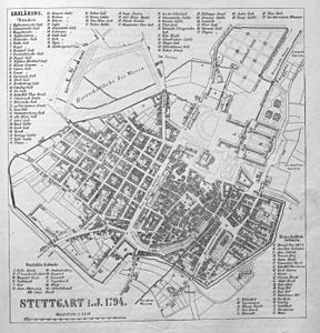
City plan from 1794.
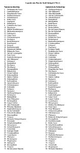
Legend.

| → Spelling of street names, column legend and sorting | ||
| Spelling of street names | ||
|
||
| Legend | ||
|
||
| Sorting | ||
|
| * | Old street name | Today's street name |
|---|---|---|
| 43 | Adelbergerhofgasse | Rathauspassage |
| Avenue street | Entered street | |
| 26th | Old Münzgasse | Turmstrasse |
| 49 | Old port market | Karlstrasse / Karls Passage |
| Old castle square | Schillerplatz | |
| At Legionskasernenplatz | Marienstrasse / Königstrasse | |
| At the Nesenbach | Josef-Hirn-Platz | |
| At the bet | Entered street | |
| On the bulwark | high Street | |
| On the ditch | Eberhardstrasse | |
| 23 | On the laimen pit, on the glue pit | Marienstrasse |
| On the plan | Planie | |
| On the press | Torstrasse | |
| 52 | On the Schönfarb | Unnamed street |
| Outer Esslinger Tor | Esslinger Strasse / Kanalstrasse | |
| Outer Tunzhofer Tor | Koenigstrasse | |
| 38 | Autenriethgäßlein, Autenriethsgasse | Steinstrasse |
| 28 | Bandgäßlein, Bandstrasse | Entered street |
| 45 | Bärengäßlein | Bear Street |
| Bear Square | Entered place | |
| 8th | Bauhofgasse | Hospitalstrasse |
| Bebenhäuser Hofgasse, Bebenhäuserstraße | Quake houses yard | |
| 44 | Bechergasse, Becherstrasse | Market street |
| 47 | Bechergäßlein, Becherwirtsgäßlein | Entered street |
| 3 | Beck Heigelingasse | Calwer Street |
| 71 | With the new houses | Katharinenstrasse |
| At the locksmith's shops | Schlosserstrasse | |
| At the vigilante guard | Koenigstrasse | |
| 52 | At the Schönfarb | Unnamed street |
| At the collegiate church | Kirchstrasse | |
| At the ballroom | Planie | |
| At the gate | Torstrasse | |
| By the lion | Rotebühlplatz | |
| At the Nesenbach | Josef-Hirn-Platz | |
| At the slaughterhouse | Karlstrasse | |
| At the little castle | Stiftstrasse | |
| By the stick | Koenigstrasse | |
| At the Welschbrückle | Sporerstrasse | |
| 54 | Benzengäßlein | Entered street |
| Mountain road | Firnhaberstrasse | |
| Busy way, busy way lane | Büchsenstrasse | |
| 10 | Biegelgasse | Heustraße |
| 22nd | Bohemian alley | Old Post Street |
| 66 | Bronnengasse, Bronnenstrasse | Pfarrstrasse |
| Brueckenstrasse | Rathauspassage | |
| Brühlgasse, Brühlstrasse | Weberstrasse | |
| Brunnengasse, Brunnenstrasse | Pfarrstrasse | |
| 12 | Büchsenkasernengasse | Leuschnerstrasse |
| Rifle gate | Büchsenstrasse | |
| Büchsentorgasse | Büchsenstrasse | |
| Bürgerhof, Bürgerhöflein | town hall | |
| Calwertor | Rotebühlplatz | |
| Cannstattertor | Neckartor | |
| 63 | Ciriacusgasse, Cyriakusgäßlein | Jakobstrasse |
| Dorotheenplatz | Entered place | |
| Dreherstrasse | Entered street | |
| Dreikönigswirtsgasse | Hauptstätter Strasse | |
| Duckstein Alley | Torstrasse | |
| 41 | Eichgasse | Eichstrasse |
| Narrow street | Entered street | |
| 7 + 8 | Engel-Bauhofgasse | Hospitalstrasse |
| 7th | Engelgasse | Hospitalstrasse |
| Esslinger Tor | Charlottenplatz | |
| 55, 70 | Esslinger Torgasse | Canal Street |
| 52 | Dye bar | Unnamed street |
| 52 | Färbergäßlein, Färberstrasse | Unnamed street |
| Sinister coin | Entered street | |
| 9 | Firnhaberische Gasse, Firnhabersche Gasse | Firnhaberstrasse |
| 33 | Fleinerisches Gäßlein, Fleinersgäßlein | wide street |
| Friedrichsplatz (1) | Marketplace | |
| Friedrichsplatz (2) | Kronenstrasse / Friedrichstrasse | |
| Friedrichstor | Friedrichstrasse / Bolzstrasse | |
| 40 | Gaisgasse, Gaißgasse, Gaisstrasse, Gaißstrasse | Geißstrasse |
| 13 | Gartengasse, Gartenstrasse | Fritz-Elsas-Strasse |
| 4th | Yellow alley | Calwer Street |
| Grabenstrasse | Entered street | |
| Big ditch | Koenigstrasse . | |
| 15th | Gymnasiistraße, Gymnasiumsgasse | Gymnasiumstrasse |
| Hahnenstrasse | Entered street | |
| Harigelsgäßlein | Rathauspassage | |
| 31 | Häringsgäßlein | Entered street |
| Hauptstättertor | Hauptstätter Strasse / Torstrasse | |
| 51 | Hauptstätter Torgasse | Torstrasse |
| 36 | Hehrengäßlein | Entered street |
| 3 | Heigelinsche Gasse, Heigelinsgasse | Calwer Street |
| 5 | Heilandengasse | Theodor-Heuss-Strasse |
| 5 + 6 | Heilanden-Rothe-Gasse | Theodor-Heuss-Strasse |
| 31 | Heringsgäßlein | Entered street |
| Herrenberg Gate | The Hauptstätter Tor became the Herrenberger Tor in 1811 | |
| Herrengäßlein | Entered street | |
| 3 | Heugelinische Gasse, Heugelische Gasse | Calwer Street |
| 3 + 4 | Heugelische-Stallmeistersgasse, Heugelinische-Stallmeistersgasse | Calwer Street |
| Hay market | Leonhardsplatz | |
| Heuwag-Kanzleigasse | Willi-Bleicher-Strasse | |
| Heylandengasse | Theodor-Heuss-Strasse | |
| Behind the Calw house | Narrow street | |
| Behind the slaughterhouse | Not determined. | |
| Behind the locksmith's shops | Büchsenstrasse | |
| Behind the town clerk | Not determined. | |
| 30th | Hirschgasse | Hirschstrasse |
| Hofdrehersgäßlein | Wilhelmstrasse | |
| 1 | Hoffmannische Gasse | Kronprinzstrasse |
| 1 + 2 | Hoffmannische Landschaftsgasse | Kronprinzstrasse |
| Hofwaschgasse | Karlstrasse | |
| 57 | Wood market, wood and herb market | Leonhardsplatz |
| 35 | Huberisches Gäßlein, Hubersgäßlein | Nadlerstrasse |
| 42 | Ilgengasse, Ilgenstrasse | Eichstrasse |
| Ilgenplatz | Nadlerstrasse | |
| In the bend | Heustraße | |
| In the kennel | Karlstrasse | |
| Inner Tunzhofer Gate | Schillerplatz / Königstrasse | |
| Jobst Street | Jobstweg | |
| 68 | Judengasse , Judenstrasse | Brennerstrasse |
| 37 | Coffee glasses | Nadlerstrasse |
| Kaffeehausgasse, Kaffeehausgäßlein | Dorotheenstrasse | |
| Cannon path | Haussmannstrasse | |
| 18th | Kanzleigasse, Kanzleistraße | Willi-Bleicher-Strasse |
| Clerk | Schillerplatz / Königstrasse | |
| Barracks | Jobstweg | |
| Kasernenstrasse | Leuschnerstrasse | |
| 17th | Kastkellereigasse | Kienestrasse |
| Church square | Kirchstrasse | |
| 29 | Kirchgasse | Kirchstrasse |
| Small ditch | Eberhardstrasse | |
| Klosterstrasse | Entered street | |
| Köllinsgasse | Lazarettstrasse | |
| 34 | Krausengäßlein, Kraussengäßlein | Entered street |
| Herb market | Leonhardsplatz | |
| Kreuzstrasse | Dornstrasse | |
| Küfers Fleinersgäßlein | wide street | |
| Küferstrasse | Entered street | |
| 32 | Kühgasse, Kuhgasse | Entered street |
| 23 | Laimen pit | Marienstrasse |
| Landhausgasse | Long street | |
| 2 | Landschaftsgasse | Kronprinzstrasse |
| 14th | Long alley | Neue Brücke / Lange Strasse |
| 48 | Long trench | Koenigstrasse / Eberhardstrasse |
| Lastinsgäßlein | Entered street | |
| 64 | Lazarettgasse | Lazarettstrasse |
| Hospital törle | Lazarettstrasse / Katharinenstrasse | |
| Ledergäßlein, Ledertorgäßlein, Lederstraße | Dorotheenstrasse / Kanalstrasse | |
| 23 | Glue pit | Marienstrasse |
| Lindengraben | Koenigstrasse | |
| Lindenstrasse | Kienestrasse | |
| Löfflerisch Gäßlein, Löfflersgasse, Löfflersgäßlein | Not determined. | |
| Lorcher Keltergäßlein | Entered street | |
| Löwenstrasse | Rotebühlstrasse | |
| Ludwigsburger Gasse, Ludwigsburger Strasse | Entered street | |
| Ludwigsburg Gate | Koenigstrasse | |
| Mackengäßlein | Entered street | |
| Butcher Autenriethgäßlein | Steinstrasse | |
| 59 | Metzgergasse, Metzgergäßlein, Metzgerstrasse (1) | Entered street |
| Metzgerstrasse (2) | Entered street | |
| Milky Way | Entered street | |
| Military road | Breitscheidstrasse | |
| 11 | Mittlere Kirchhofgasse, Mittlere Kirchhofstrasse | high Street |
| Nägelinsgäßlein | Eichstrasse | |
| New bridge | New bridge | |
| New Eßlingerstrasse | Charlottenstrasse | |
| 24 | New alley | Narrow street |
| 46 | New Münzgasse | Marktstrasse / Münzstrasse |
| New street | Fürstenstrasse | |
| New port market | Leonhardsplatz | |
| New Schlossplatz | Schlossplatz | |
| Up at the rifle gate barracks | Leuschnerstrasse | |
| Upper Bachstrasse | Nesenbachstrasse / Josef-Hirn-Platz | |
| Upper Alley | wide street | |
| 53 | Ochsenwirtsgäßlein | Dornstrasse |
| 39 | Ordonanzgasse | Steinstrasse |
| Paulinenstrasse | Paulinenstrasse / Tübinger Strasse | |
| 65 | Pfarrgasse, Pfarrstrasse | Entered street |
| Postgasse, Poststrasse | Old Post Street | |
| Postplatz | Rotebühlplatz | |
| Quergasse, Querstraße | Wiederholdstrasse | |
| Rappengäßlein, Rappenstrasse | Räpplenstrasse | |
| Vine Road | Not determined. | |
| Reifgasse, Reifstrasse | Entered street | |
| 56 | Römischkönigsgasse, Römische Königwirtsgasse | Holzstrasse |
| 69 | Rosengasse, Rosengäßlein (1) | Rosenstrasse |
| Rosengäßlein (2) | Entered street | |
| 6th | Rothe Gasse, Rothe Strasse | Theodor-Heuss-Strasse |
| 20th | Rothebildtorstraße, Rothenbildtorstraße, Rothenbühlstraße, Rothbühltorstraße | Rotebühlstrasse |
| Rothes Bildtor | Rotebühlstrasse | |
| Beet, bucket and wood market | Leonhardsplatz | |
| Rupfergäßlein, Rupfersgäßlein | Entered street | |
| Sailtor | Tübinger Strasse / Eberhardstrasse | |
| 58 | Scharfrichtergäßlein | Straightening road |
| Schauffelers Gasse, Schaufflers Gasse | Not determined. | |
| Schellenturmgasse | Canal Street | |
| 60 | Schlachthausgasse, Schlachthausgäßlein | Rosenstrasse |
| Schlossgartenstrasse | Entered street | |
| Palace Square | - | |
| Schlossstrasse | Schlossstrasse | |
| 52 | Schönfarbgasse | Unnamed street |
| Schreinerstrasse | Entered street | |
| Shoe ditch | Koenigstrasse | |
| 21st | Schulerisch Gäßlein, Schulerisches Gäßlein, Schuler's Gäßlein | Entered street |
| 27 | School alley | Schulstrasse |
| Schusterstrasse | wide street | |
| 19th | Seegasse | Friedrichstrasse |
| Seegassentor | Friedrichstrasse / Bolzstrasse | |
| Seeltor, rope gate | Tübinger Strasse / Eberhardstrasse | |
| Siechengasse | Koenigstrasse | |
| Sick gate | Koenigstrasse | |
| So-called ditch | Koenigstrasse | |
| Sonnenstrasse | Not determined. | |
| Spezialat-Gymnasiumsgasse | Gymnasiumstrasse | |
| Spitalgasse | Firnhaberstrasse | |
| Hospital place | Hospital place | |
| St. Leonhardsplatz | Leonhardsplatz | |
| St. Leonhardstrasse | Leonhardstrasse | |
| 25th | Stadtschreiberereigasse | wide street |
| Stadtgasse, city street | Hirschstrasse | |
| 4th | Stallmeistereigasse, Stallmeistersgasse | Calwer Street |
| Steußengäßlein | Not determined. | |
| Stickelsgäßlein | Not determined. | |
| Stiftskirchenplatz | Kirchstrasse | |
| Stöckachstrasse | Werastrasse | |
| 16 | Stockgasse, Stockstrasse | Büchsenstrasse |
| Floor space | Koenigstrasse | |
| Gate alley | Canal Street | |
| 61 | Totengasse, Totenstrasse | Leonhardstrasse / Leonhardplatz |
| Traiteur-Mackengäßlein | Entered street | |
| Tuebinger Strasse | Paulinenstrasse / Tübinger Strasse | |
| Tübinger Tor (until 1818) | Tübinger Strasse / Eberhardstrasse | |
| Tübinger Tor (from 1822) | Hauptstätter Strasse | |
| Tunzhofer Gate | Schillerplatz / Königstrasse | |
| Under the linden trees | Koenigstrasse | |
| Under the wall | Entered street | |
| Lower Bachstrasse | Entered street | |
| Lower tournament field | Koenigstrasse | |
| Vogteigasse | Turmstrasse | |
| 4th | Full alley | Calwer Street |
| Guardhouse Square, Guardhouse Square | Koenigstrasse | |
| 67 | Wagnergasse | Wagnerstrasse |
| 50 | Wälsches Brückle | Sporerstrasse |
| Water soup alley | Firnhaberstrasse | |
| Wine route | Entered street | |
| Weißisches Gäßlein, Weißes Gäßlein | Torstrasse | |
| 50 | Welschbrückle, Welsches Brückle | Sporerstrasse |
| Wilhelmstor | Junction Olgastraße / Wilhelmstraße | |
| Wilhelmstrasse | Hirschstrasse | |
| Wurststrasse | Sophienstrasse | |
| Zilockengäßlein, Zilockengäßlein | Jakobstrasse |
Historical city maps
To locate historical addresses, it is sufficient in many cases to consult the historical street name comparison table. In some cases it is advisable to compare historical city maps with today's city maps in order to determine the exact location and extent of a street, e.g. B. if an old street name only describes part of the current street. The following table lists historical city maps that can be used to locate old streets.
Until 1811 the houses were not numbered by street, but consecutively. B. the house numbers 1 to 1374. These house numbers are drawn in the plan 1794.2 , and in the plan from 1846 the house numbers counted street by street from 1811 onwards . Both plans can be used when a historical address is to be located.
Some of the plans include lists of streets, lists of buildings, or lists of other prominent points that can sometimes be helpful when looking up historical addresses.
The following plans can be found in the album Historical City Maps of Stuttgart .
| year | source | Lists | particularities |
|---|---|---|---|
| 1640 | 1640 plan | Gates, towers, buildings | |
| 1652 | Plan 1652 | Gates, towers | |
| 1764 | 1764 plan | ||
| 1771 | 1771 plan | Streets, buildings | |
| 1780 | Plan 1780 | Streets, buildings | |
| 1794.1 | Plan 1794.1 | Streets, buildings | |
| 1794.2 | Plan 1794.2 | House numbers | |
| 1831 | Plan 1831 | building | |
| 1846 | Plan 1846 | Streets | House numbers |
| 1846/1871 | Plan 1846/1871 | ||
| 1888 | Plan 1888 | Streets | |
| 1896.2 | Plan 1896.2 | Streets, buildings | |
| 1909 | 1909 plan | Streets |
Historic suburbs and districts
Before 1811, Stuttgart was divided into parts of the city that (apart from the old town) were called suburbs. When locating historical addresses, it is sometimes useful to know the location of the suburbs. The following table gives an overview of the historical suburbs.
In 1811 the division into suburbs was replaced by the division into four districts. These were designated with the letters AD or Lit. AD. The allocation of the streets to the districts can be found z. B. in Pfaff 1846 , pages 549-553.
| Year of origin | Suburb | location |
|---|---|---|
| Old town inner city |
District between Oberer Königstrasse, Eberhardstrasse and Planie | |
1393 |
St. Leonhardsvorstadt Esslinger Vorstadt Bohnenviertel |
District southeast of Eberhardstrasse |
1453 |
Rich suburb Liebfrauenvorstadt |
A chessboard-like district northwest of Königstrasse |
1806 |
Friedrichsvorstadt | District around the lower Koenigstrasse |
1807 |
Tübingen suburb Herrenberger Vorstadt Gerbervorstadt |
District around Tübinger Strasse |
literature
-
Max Bach (editor); Carl Lotter: Pictures from Old Stuttgart , Stuttgart 1896.
- Max Bach (drawing); A. Eckstein (engraving): Stuttgart around 1640 , panel I.
- Christian Friedrich Roth (drawing); Gottlieb Friedrich Abel (engraving): Stuttgart i. J. 1794 , p. 81.
- Gentner (drawing); A. Eckstein (engraving): Stuttgart year 1831 , panel III.
- Stuttgart . In: Brockhaus' Konversationslexikon , 14th edition, Volume 15, Leipzig 1896, after page 464.
-
Johannes Friz: Collection of police laws and ordinances for the royal Würtemberg'sche residence city Stuttgart , Stuttgart 1829.
- Policei Ordinance of May 12, 1811, concerning the new numbering of houses and naming of the streets, pages 73–78.
- Royal Decree of May 20, 1811 regarding the names of the gates, page 78.
- Royal decree of May 23, 1811 regarding the naming of Büchsenstrasse, page 79.
- Announcement of March 1, 1820 (by the Intelligence Gazette) regarding the naming of some new streets, page 191.
- Hans Hammer (editor): Street names in Stuttgart: origin and meaning , Stuttgart 1974.
- Hermann Lenz ; Günter Beysiegel (editor): Stuttgart. from 12 years of life in Stuttgart. Stuttgart: Belser, 1983.
- Carl Lotter: The Stuttgart street names . In: Stuttgarter Mitteilungen über Kunst und Gewerbe 1905–1906, pp. 51–59 [1] .
- Hermann Missenharter: Dukes, citizens, kings: Stuttgart's history as it is not in a school book. Drawings by Heinrich Klumbies. Stuttgart 2005.
- Stuttgart . In: Meyers Konversations-Lexikon , 4th edition, Volume 15, Leipzig 1888, after page 409.
- Stuttgart . In: Meyers Großes Konversations-Lexikon , 6th edition, Volume 19, Leipzig 1909, after page 154.
-
Karl Pfaff : History of the city of Stuttgart based on archival documents and other proven sources . Volume 2: History of the city from 1651 to 1845 , Stuttgart 1846.
- Topography of the city, its inhabitants, way of life and customs , pages 1–184.
- List of streets and public places in Stuttgart , pages 549–553.
- Harald Schukraft: Stuttgart Street History (s). Stuttgart 1987.
-
Gustav Wais : Old Stuttgart: the oldest buildings, views and city plans up to 1800; with city history, architectural history and art history explanations , Stuttgart 1954.
- 1794 Chr. Friedr. Roth - Gottlieb Friedr. Abel (plate 52 in the appendix) , pages 248–256.
- Plan of the city of Stuttgart from 1652 (Nesenbach flood) with the 43 city gates and city towers, pen drawing by an unknown hand , plate 38.
- Jonathan Lenz (drawing): Floor plan of the ducal wurtemberg: Residenz-Stadt Stuttgart 1764 , plate 47.
- Plan of the city of Stuttgart 1771, excerpt from the Corps des Guides map , plate 48.
- Jakob Ludwig Roth (drawing); Makarius Balleis (engraving): Basic crack of the Herzoglich Wurtemberg: main and first residence city of Stuttgardt , plate 50.
- Christian Friedrich Roth (drawing); Gottlieb Friedrich Abel (engraving): Basic crack of the Herzoglich Wirtembergischen main and first residence city of Stuttgardt MDCCXCIV , plate 52.
- Ms. Bohnert (drawing); HA Schurath (engraving): Stuttgart 1846 a. 1871 . In: Georg Wochner: Stuttgart for five and twenty years. Views from the capital, tried to draw in a series of pictures , Stuttgart 1871, fold-out panel.
See also
- Stuttgarter Stäffele , with a list of the Stuttgart Stäffele.
Web links
Individual evidence
- ↑ See Historic Suburbs and Districts .
- ^ The Adelbergerhofgasse was roughly identical to the northern section of the Rathauspassage, which runs from the southwest corner of the market square to Eberhardstrasse.
- ↑ Alleenstrasse was in the city garden between Kriegsbergstrasse and Schellingstrasse. It began on Holzgartenstrasse and ended on Friedrichstrasse.
- ↑ The Alte Münzgasse was identical to the Turmstrasse and continued northwest to the street Unter der Mauer. See plan 1764 .
- ↑ The legionary barracks were located at the confluence of Marienstraße and Königstraße, on the site of today's Wilhelmsbau.
- ↑ The street An dem Nesenbach began roughly with Josef-Hirn-Platz and ended between Dornstrasse and Rathauspassage. See plan 1764 .
- ^ The street An der Wette ran parallel to the Leonhardskirche in the extension of the street An dem Nesenbach and ended between the Rathauspassage and Marktstraße. See plan 1764 .
- ↑ See: Kleiner Graben.
- ↑ The section of Torstrasse at Hauptstätter Tor between Hauptstätter Strasse and Nesenbachstrasse was called Auf der Presse.
- ↑ The street Auf der Schönfarb (Färberstrasse) began roughly between the houses Eberhardstrasse 35 and 41 and ended at the house at Hauptstätter Strasse 35.
- ↑ See: Esslinger Tor.
- ↑ See: Siechentor.
- ↑ #Schukraft 1987 , page 23: “On the market square you can see between the houses Haufler and Mayer am Markt [Marktplatz 5 and 6] in a nameless path, which after a few meters turns right to Stiftstrasse and at the intersection of Stiftstrasse and Kirchstrasse ends. This backyard driveway corresponds exactly to the former Bandstrasse, which only the old cobblestones and curbs remind of. "
- ^ The Bärenplatz (Dorotheenplatz) was on the grounds of the market hall.
- ↑ The southern section of today's Hospitalstrasse was identical to Engelgasse and continued north from the Hospital Church in Bauhofgasse. Both streets together were called Engel-Bauhofgasse. The northern section of Willi-Bleicher-Strasse was also referred to as Bauhofgasse. See plan 1764 .
- ↑ The Bebenhäuser Hofgasse was identical to the northwest section of the street Bebenhäuser Hof and continued to Königstraße. See plan 1764 .
- ↑ Bechergasse formed the northwest arm of Marktstrasse.
- ↑ The Bechergäßlein branched off from the southwest section of Marktstrasse and was located between the Karls-Passage and the parallel northwest section of Marktstrasse.
- ↑ See: Heigelinsche Gasse.
- ↑ The exact place where the street at the civil guard was not known.
- ↑ See: On the Schönfarb.
- ↑ The place near the collegiate church was between the collegiate church and Kirchstrasse. See plan 1764 .
- ↑ The section of Torstrasse near Nesenbach was called Beim Gatter.
- ^ The street at the lion was the section of the Rotebühlplatz between Königstraße and Theodor-Heuss-Straße. See plan 1764 .
- ↑ See: At the Nesenbach.
- ↑ See plan 1764 .
- ↑ The exact location of the road near the Stock is not known.
- ↑ The Benzengäßlein ran parallel between Dornstrasse and Rathauspassage. It began on Eberhardstrasse and ended on Hauptstätter Strasse. See plan 1764 .
- ↑ The occupied way was the southeast half of Büchsenstrasse. See plan 1764 .
- ↑ See plan 1764 .
- ↑ See plan 1764 .
- ↑ The Brückenstraße was roughly identical to the section of the Rathauspassage between Eberhardstraße and Hauptstätter Straße.
- ↑ Brühlgasse was the section of Weberstrasse from the Schellenturm to Kanalstrasse; see map 1764 .
- ↑ See plan 1764 .
- ↑ The Büchsentor was at the northern end of Büchsenstrasse. See plan 1764 .
- ↑ Büchsentorgasse was by the Büchsentor and was the northwestern half of Büchsenstrasse. See plan 1764 .
- ↑ The Bürgerhof was a building near Hirschstrasse on the area of today's town hall. See plan 1771 and legend 1771 .
- ↑ The Calwertor, demolished in 1836, was located at the confluence with Rotebühlplatz. See Hammer 1974 , keyword “Calwer Straße”.
- ↑ Hammer 1974 , keyword “Jakobstrasse”.
- ↑ See: Bärenplatz.
- ↑ Dreherstrasse (Finstere Münz) was between Bebenhäuser Hof and Turmstrasse. Dark coin: See plan 1764 .
- ↑ Dreikönigswirtsgasse was the section of Hauptstätter Strasse between Pfarrstrasse and Kanalstrasse. See plan 1764 .
- ↑ The Eichgasse formed the north-western section of today's Eichstrasse.
- ↑ The Enge Straße (Lorcher Keltergäßlein, Lastinsgäßlein), today Sporerstraße 4–12, connected the Bärenstraße with the Kirchstraße. The extension of Engen Strasse beyond Kirchstrasse was Grabenstrasse.
- ↑ See: Bauhofgasse.
- ↑ See: Bauhofgasse.
- ↑ The Esslinger Tor (outer Esslinger Tor) was on Charlottenplatz. See Hammer 1974 , keyword “Charlottenplatz”.
- ↑ Esslinger Torgasse was the section of Kanalstrasse between Esslinger Strasse and Holzstrasse. The other section of Kanalstrasse was called Schellenturmgasse or Torgasse. See plan 1764 .
- ↑ See: On the Schönfarb.
- ↑ See: On the Schönfarb.
- ↑ See: Dreherstrasse.
- ↑ The Fleinerisches Gäßlein was the section of the Breiten Strasse between Hirschstrasse and Steinstrasse.
- ↑ The market square was called Friedrichsplatz from 1811–1832. See Lotter 1905 , page 52.
- ↑ Friedrichsplatz, which was newly founded in 1888 and reopened after 1974, was at the intersection of Kronenstrasse and Friedrichstrasse. See Hammer 1974 , keyword “Friedrichsplatz” and plan 1896.2 and legend 1896.2 .
- ↑ The Friedrichstor was located at the confluence of Bolzstrasse and Friedrichstrasse.
- ↑ See plan 1764 .
- ↑ See: Heigelinsche Gasse.
- ↑ See: Narrow Street.
- ↑ The Große Graben was the section of Königstraße from the Königsbau to Marienstraße. See also: Kleiner Graben and Großer Graben.
- ↑ See plan 1764 .
- ↑ Hahnenstrasse connected the northwest arm of Marktstrasse (formerly Becherstrasse) with Münzstrasse.
- ↑ See: Adelbergerhofgasse.
- ^ Parallel to Eberhardstrasse and Breiten Strasse and between these two streets ran the Häringsgasse to the west and the Kühgasse (Milky Way) to the east. Both streets began on Hirschstrasse and ended on Steinstrasse.
- ↑ The Hauptstättertor was at the confluence of Torstrasse and Hauptstätter Strasse. See plan 1764 .
- ↑ The Hehrengäßlein was between Nadlerstraße and Broad Street. It started around the house at Hirschstrasse 27 and ended at Steinstrasse.
- ↑ The Heigelinsche Gasse (Heigelinsgasse, Beck Heigelinsgasse, Heugelinische Gasse, Heugelische Gasse) located in the south of today's Calwer Strasse continued to the north in the Stallmeistereigasse (Stallmeistersgasse, Volle Gasse, Yellow Gasse). Both streets together were called Heugelinische-Stallmeistersgasse (Heugelische-Stallmeistersgasse). See plan 1764 ; Plan 1794.1 and legend 1794.1 .
- ↑ Heilandengasse, located in the south of today's Theodor-Heuss-Strasse, continued to the north in Rothen Gasse. Both streets together were called Heilanden-Rote-Gasse and renamed Rote Gasse in 1811. See plan 1764 .
- ↑ See: Heilandengasse.
- ↑ See: Häringsgäßlein.
- ↑ See: Küferstrasse.
- ↑ See: Heigelinsche Gasse.
- ↑ See: Heigelinsche Gasse.
- ^ Hammer 1974 , keyword "Leonhardsplatz".
- ↑ See Heilandengasse.
- ^ The Hirschgasse was renamed Wilhelmstrasse in 1811 and Hirschstrasse in 1832. See Hammer 1974 , keyword “Hirschstrasse”.
- ↑ The Hoffmännische Gasse, located in the south of today's Kronprinzenstrasse, continued north in the Landschaftsgasse to around today's Schloßplatz, both streets together were referred to as Hoffmannnische Landschaftsgasse. See plan 1764 .
- ↑ See: Hoffmannnische Gasse.
- ^ Hammer 1974 , keyword "Leonhardsplatz".
- ↑ Ilgengasse formed the southeastern section of today's Eichstrasse.
- ↑ Ilgenplatz was at the southern end of Nadlerstrasse.
- ↑ The exact location of the street Im Zwinger has not been determined.
- ↑ See: Chancellery.
- ^ Wais 1954 , page 254.
- ↑ The Kaffeegäßlein formed the section of Nadlerstrasse between Hirschstrasse and Steinstrasse.
- ↑ See plan 1764 .
- ↑ The chancellery (Inneres Tunzhofer Tor, Dänzlinger Tor) was located within the passage (the archway called the chancellery arch) between the Prinzenbau and the old chancellery. See plan 1764 .
- ^ Wais 1954 , page 254.
- ↑ See plan 1764 .
- ↑ See plan 1764 .
- ↑ The Kleine Graben (Auf dem Graben) was the section of Eberhardstrasse between Steinstrasse and Marktstrasse. See plan 1764 . In Plan 1771 and Legend 1771 , the Große Graben is referred to as Auf dem Graben and in Plan 1794.2 the Kleine Graben is referred to as Langer Graben. See also: Kleiner Graben and Großer Graben.
- ↑ The Klosterstrasse continued the entered Ilgenstrasse to the Marktstrasse.
- ↑ The Krausengäßlein was the extension of Geissstrasse to the northwest and ran parallel to Breiten Strasse and Pierre-Pflimlin-Platz.
- ^ Hammer 1974 , keyword "Leonhardsplatz".
- ↑ See: Fleinerisches Gäßlein.
- ↑ Parallel to Nadlerstraße and between this and the market went south the Küferstraße (Herrengäßle, Mackengäßle, Rosengäßle) and north of the Metzgerstraße (2).
- ↑ See: Häringsgäßlein.
- ↑ The Landhausgasse was the upper section of the Long Street.
- ↑ See: Hoffmannnische Gasse.
- ↑ The Lange Gasse consisted of the street Neue Brücke and the section of the Langen Straße between Königstraße and Theodor-Heuss-Straße. See plan 1764 .
- ↑ The Lange Graben was the "bend between the Great and Small Graben, ie in today's Wilhelmsbau between Königstrasse and Eberhardstrasse" ( Wais 1954 , page 126). It reached as far as the confluence with Steinstrasse. See also: Kleiner Graben and Großer Graben as well as Plan 1764 .
- ↑ See: Narrow Street.
- ↑ The Lazaretttörle was at the confluence of Lazarettstrasse with Katharinenstrasse. See plan 1764 .
- ↑ The Ledergäßlein consisted of a section of Dorotheenstrasse parallel to the south-west facade of the old orphanage and of Kanalstrasse.
- ↑ The Lindengraben was the part of Königstrasse between Schulstrasse and Alte Poststrasse. See plan 1640 and legend 1640 .
- ↑ See: Narrow Street.
- ↑ Ludwigsburger Strasse began at Königstor at the end of Königstrasse and ran over Nordbahnhofstrasse to Löwentor on Pragstrasse (city maps 1905, 1909), later it ended at Wolframstrasse (city maps 1915, 1925).
- ↑ See: Siechentor.
- ↑ See: Küferstrasse.
- ↑ Metzgergasse was the extension of Wagnerstrasse to the northwest and ran from Esslinger Strasse to Holzstrasse. See plan 1764 .
- ↑ See: Küferstrasse.
- ↑ See: Häringsgäßlein.
- ↑ The military road occupied the western section of the Breitscheidstrasse up to the Büchsenstrasse. A section of the military road that had been received led from there to the Katharinenkrankenhaus on Kriegsbergstrasse.
- ↑ See plan 1764 .
- ↑ The street Neue Brücke was founded in 1745, built into Langen Strasse in 1761, renamed Neue Brücke again in 1800, again counted as Langen Strasse in 1811, since 1832 it was again called Neue Brücke (except 1934–1945). See Hammer 1974 , keyword “New Bridge”.
- ↑ See plan 1764 .
- ^ The Neue Münzgasse was made up of the northwest section of Marktstrasse and Münzstrasse.
- ^ Hammer 1974 , keyword "Leonhardsplatz".
- ↑ Obere Bachstrasse comprised Nesenbachstrasse between Christophstrasse and Torstrasse and continued over Josef-Hirn-Platz to Marktstrasse.
- ↑ See plan 1764 .
- ↑ See: Tübinger Strasse.
- ↑ Today's Pfarrstrasse is identical to the earlier Bronnengasse / -strasse or Brunnengasse / -strasse. The former Pfarrgasse (Pfarrstrasse) was between today's Pfarrstrasse and Lazarettstrasse. See plan 1764 .
- ^ Hammer 1974 , keyword "Alte Poststraße".
- ↑ #Missenharter 2005 , page 307.
- ↑ See plan 1896.2 and legend 1896.2 .
- ↑ The Reifgasse began on the southwest arm of the Marktstrasse, ran a piece parallel to the northwest arm of the Marktstrasse and then flowed into it.
- ^ See Wais 1954 , p. 273.
- ↑ The Rosengasse was the section of the Rosenstrasse southeast of the Esslinger Strasse. See plan 1764 .
- ↑ See: Küferstrasse.
- ↑ See: Heilandengasse.
- ↑ The Rothe Bildtor stood in Rotebühlstrasse roughly at the level of today's Rotebühl barracks.
- ^ Hammer 1974 , keyword "Leonhardsplatz".
- ↑ See: Reifgasse.
- ↑ See: rope gate.
- ↑ See plan 1764 .
- ↑ See: Esslinger Torgasse.
- ↑ Schlachthausgasse was the section of Rosenstrasse between Esslinger Strasse and Holzstrasse. See plan 1764 .
- ^ Street parallel to the northeast facade of the New Palace. See plan 1896.2 and legend 1896.2 .
- ↑ Schlossstrasse used to continue along Börsestrasse and ended with Bolzstrasse, which today leads to the New Palace. See Hammer 1974 , keyword “Schlossstrasse”.
- ↑ See: On the Schönfarb.
- ↑ See: Krausengäßlein.
- ↑ The Schuhgraben was the part of Königstrasse opposite the midnight building (Königstrasse 46).
- ↑ The Schulerisch Gäßlein was between the Alte Poststrasse and the Rotebühlplatz. It began on Calwer Strasse and ended on Kronprinzstrasse.
- ↑ See: Fleinerisches Gäßlein.
- ↑ See: Friedrichstor.
- ↑ The rope gate (Sailtor, Seeltor, Tübinger Tor) was on the corner of Tübinger Strasse and Eberhardstrasse, near the Seelhaus on the corner of Tübinger Strasse and Christophstrasse. See plan 1640 and legend 1640 .
- ↑ The exact location of the Siechengasse has not been determined.
- ^ The Siechentor (outer Tunzhofer Tor, from 1704 Ludwigsburg Gate) was located at the intersection of Königstrasse and Bolzstrasse.
- ^ The Spitalgasse consisted of two streets, Firnhaberstraße and the section of Gymnasiumstraße between Hospitalkirche and Leuschnerstraße. See plan 1764 .
- ^ The Stadtschreibereigasse was the section of the Breiten Strasse between Königstrasse and Hirschstrasse. See plan 1764 .
- ↑ The Hirschstrasse was called Stadtgasse until 1740. See Hammer 1974 , keyword “Hirschstrasse”.
- ↑ See: Heigelinsche Gasse.
- ↑ Stockplatz was the section of Königstrasse between Büchsenstrasse and Kienestrasse. The floor building was located on Carré Königstrasse, Büchsenstrasse, Kronprinzstrasse and Kienestrasse.
- ↑ See: Esslinger Torgasse.
- ↑ See: Küferstrasse.
- ↑ The southern section of today's Paulinenstraße between Hauptstätter Straße and the intersection Paulinenstraße / Tübinger Straße belonged to Tübinger Straße. The rest of the Tübinger Strasse stretched from Paulinenstrasse east to Eberhardstrasse. In 1831 only the beginning of Paulinenstrasse existed at the confluence with Rotebühlstrasse.
- ↑ See: rope gate.
- ^ The Tübinger Tor was at the intersection of Hauptstätter Strasse and Paulinenstrasse.
- ↑ See: Chancellery and Infirmary.
- ^ The avenue Unter den Linden was the part of the Königstraße between Schulstraße and Alte Poststraße. See plan 1640 and legend 1640 .
- ↑ The street under the wall was the north-eastern continuation of the narrow street between Neuer Brücke and Schulstrasse. See plan 1764 .
- ↑ Untere Bachstrasse ran parallel to Holzstrasse and Karlstrasse between Wagnerstrasse and Dorotheenstrasse.
- ↑ See: Heigelinsche Gasse.
- ↑ The Wachhausplatz was on Königstrasse in front of the Hauptwache between Gymnasiumstrasse and Büchsenstrasse.
- ↑ The Weinstraße ran parallel to the Alte Poststraße and between this and the Rotebühlplatz.
- ↑ # Lenz 1983 , page 266.
- ↑ Hirschstrasse was called Wilhelmstrasse from 1811 to 1832, before that Hirschgasse and then Hirschstrasse. From 1832, today's Wilhelmstrasse was given this name. See Hammer 1974 , keyword “Hirschstrasse”.
- ↑ Wurststrasse was the upper section of Sophienstrasse.
- ↑ Hammer 1974 , keyword “Jakobstrasse”.
- ^ Wais 1954 , page 248.
- ↑ Pfaff 1846 , pp. 8–9, 15.
- ↑ lit. stands for Littera = letter.
- ↑ The upper Königstraße is the section between Königsbau and Rotebühlplatz.
- ↑ Older names: Obere Vorstadt, Neue Vorstadt, tournament archery suburb.
- ↑ The lower Königstraße is the section between the Königsbau and the main train station.