Lockyer Island
| Lockyer Island | ||
|---|---|---|
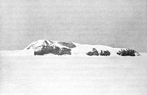
| Lockyer Island from the north | ||
| Waters | Weddell Sea | |
| Archipelago | Ross Islands | |
| Geographical location | 64 ° 26 '51 " S , 57 ° 35' 55" W | |
|
|
||
| length | 5.5 km | |
| width | 3.5 km | |
| surface | 11 km² | |
| Highest elevation | 450 m | |
| Residents | uninhabited | |
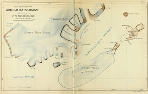
| Map of the Swedish Antarctic Expedition | ||
The Lockyer Island ( English Lockyer Island , Spanish isla Lockyer ) is a rocky, heavily glaciated island in the Weddell Sea . It is located about 55 km east of the Antarctic Peninsula .
geography
The island is located at the southwest exit of Admiralty Road . It is 5 km from Snow Hill Island in the east and about 5.5 km from Jefford Point on James Ross Island to the north . Lockyer Island is about 5.5 km long from northeast to southwest at a width of 3.5 km. The approximately 450 m high island drops steeply on all sides. The lower south-western part carries an ice cap , from which several wide glaciers extend to the coast.
history
James Clark Ross discovered the island on January 7, 1843 from a great distance and believed it to be a cape of a larger country. At the request of his officer Francis Crozier , he named it after his friend Nicholas Lockyer (1782–1847) Cape Lockyer . It was not until Otto Nordenskjöld realized in 1902 during the Swedish Antarctic Expedition that it was an island. The expedition had their winter quarters on the nearby Snow Hill Island.
Individual evidence
- ↑ a b Lockyer Island in the Australian Antarctic Data Center (English)
- ↑ Otto Nordenskjöld: Scientific results of the Swedish south polar expedition 1901-1903 . Vol. 1, Delivery 1: The Swedish South Polar Expedition and its geographical activity , Lithographic Institute of the General Staff, Stockholm 1911, p. 134


