Long Island (Papua New Guinea)
| long Island | ||
|---|---|---|
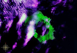
| False color image from space. Lake Wisdom is clearly visible in the picture. | ||
| Waters | Bismarck lake | |
| Geographical location | 5 ° 21 ′ S , 147 ° 7 ′ E | |
|
|
||
| surface | 357 km² | |
| Highest elevation | Bunaga 1280 m |
|
| Residents | 1000 (2001) 2.8 inhabitants / km² |
|
| main place | Matafum (Matupan) | |
Long Island is a volcanic island north of Papua New Guinea . The Vitiaz Strait runs between the two islands .
geography
There are two stratovolcanoes on the island: Mount Reaumur and Cerisy Peak . The summit of the volcanic complex collapsed during at least three major eruptions, around 16,000, 4,000, and 300 years ago. These left behind a large caldera that measures 10 × 12.5 km and is now filled by a crater lake, Lake Wisdom . The last eruption was one of the strongest in Papua New Guinea's recent history with an estimated volume of over 11 km³, comparable to the Pinatubo eruption in 1991.
A minor eruption dates back to 1993.
Today the island has five villages with around 1000 inhabitants.
Administratively, the island belongs to the Raicoast District in the southeast of the Madang Province .
history
Long Island was mapped by Abel Tasman in 1643 . He mistakenly believed the island to be part of New Guinea .
During the Second World War , a radar station was set up on the island by the Australian Air Force .
Individual evidence
- ↑ Hoffmann, G .; Silver, E .; Day, S .: Volcanic flow deposits on the flanks of Long Island, Papua New Guinea: lavas or pyroclastics? . In: American Geophysical Union, Fall Meeting 2008, abstract # V11C-2067 . August. bibcode : 2008AGUFM.V11C2067H .
- ↑ S. Cook, R. Singidan and IWB Thornton: Colonization of an Island Volcano, Long Island, Papua New Guinea, and an Emergent Island, Motmot, in Its Caldera Lake. IV. Colonization by Non-Avian Vertebrates , Journal of Biogeography, Vol. 28, No. 11/12, Special Issue: Long Island, Papua New Guinea: A Nested Pair of Colonization Sequences (Nov. - Dec., 2001), pp. 1353–1363, here p. 1354.
- ↑ District map of the province of Madang ( page no longer available , search in web archives ) Info: The link was automatically marked as defective. Please check the link according to the instructions and then remove this notice.

