Vicente Guerrero (Mexicali)
| Vicente Guerrero | ||
|---|---|---|
|
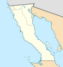
Coordinates: 32 ° 43 ′ N , 114 ° 44 ′ W Vicente Guerrero on the map of Baja California
|
||
| Basic data | ||
| Country | Mexico | |
| State | Baja California | |
| Municipio | Mexicali | |
| Residents | 5474 (2010) | |
| Detailed data | ||
| height | 40 m | |
| The border between Mexico and the USA between Vicente Guerrero and Andrade in California | ||
Vicente Guerrero , also known as Los Algodones , is a place in the municipality ( municipio ) Mexicali in the Mexican state of Baja California on the Río Colorado . Los Algodones has 4,157 inhabitants and is located in the extreme northeast of the state of Baja California on the border with California and Arizona . There are around 200 dentists in the city, the northernmost of Mexico, because many Americans come to Mexico because dental treatment is cheaper in Mexico.
The Algodones Dunes , which stretch north from here and are a popular area for off-road vehicles in California, are named after the city .

