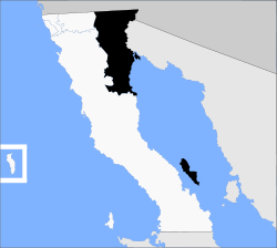
Municipio Mexicali
| Mexicali | ||
|---|---|---|

|
||
| Symbols | ||
|
||
| Basic data | ||
| Country | Mexico | |
| State | Baja California | |
| Seat | Mexicali | |
| surface | 15,665.2 km² | |
| Residents | 936,826 (2010) | |
| density | 59.8 inhabitants per km² | |
| founding | 1954 | |
| Website | mexicali.gob.mx | |
| INEGI no. | 02002 | |
| politics | ||
| Presidente municipal | Gustavo Sánchez Vázquez | |
Coordinates: 32 ° 0 ′ N , 115 ° 12 ′ W
Mexicali is a municipality in the Mexican state of Baja California . With an area of 15,665 km², the municipality had 936,826 inhabitants at the 2010 census. The administrative seat and largest city of the municipality is the Mexicali of the same name .
geography
The Mexicali Municipality forms the north-east of the state of Baja California and is located at the beginning of the peninsula Baja California on the side of the Gulf of California . The municipality also includes several islands in the Gulf of California, including Isla Montague , Isla Ángel de la Guarda , Isla Coronado and the San Lorenzo Archipelago .
In the municipality of Mexicali, the Laguna Salada depression is the lowest point in Mexico. The highest point of the municipality is at 1900 m . 69% of the parish is in the Physiographic Province of the Plains of Sonora, 31% in the Baja California Peninsula; 66% is in the hydrographic region of Baja California Noreste , 34% drains over the Río Colorado . Geologically, the municipality is composed of 46% alluvions , 16% lacustrian rock, 12% intrusive rock , around 10% sedimentary rock and 8.5% extrusive rock . The predominant soil types are the Leptosol (23.5%), Regosol (22.7%), Solonchak (15.9%) and Arenosol (13.2%). About 60% of the municipality is covered by scrub landscape, about 15% are used for agriculture.
The municipality of Mexicali is bordered by the municipality of Ensenada to the south, Tecate to the west, the US state of California to the north, and the US state of Arizona and the Mexican state of Sonora to the east .
population
According to the 2010 census, the municipality has 936,826 inhabitants in around 260,000 residential units. Of these, 4,036 persons were identified as speakers of indigenous languages recorded, including about 535 speakers of Mixtec and 308 speakers of Nahuatl . About 2.3% of the population were illiterate. 404,701 inhabitants were registered as economically active, of which approx. 64% were men or 4.5% were unemployed. 2.6% of the population lived in extreme poverty.
places
The Municipio Mexicali comprises 1650 inhabited localidades , 19 of which are classified as urban by the INEGI . Twelve places had a population of over 5000 in the 2010 census, another 32 places had at least 1000 inhabitants, and almost 1500 places had fewer than 100 inhabitants. The biggest places are:
| place | Residents |
| Mexicali | 689.775 |
| Santa Isabel | 29,311 |
| Ciudad Guadalupe Victoria ( Kilómetro Cuarenta y Tres ) | 17,119 |
| San Felipe | 16,702 |
| Puebla | 15,168 |
| Progreso | 12,557 |
| Ciudad Morelos ( Cuervos ) | 8,243 |
| Colonia Venustiano Carranza ( La Carranza ) | 6,098 |
| Ciudad Coahuila ( Kilómetro Cincuenta y Siete ) | 5,617 |
| Vicente Guerrero ( Algodones ) | 5,474 |
| Delta ( Estación Delta ) | 5,180 |
| Ejido Hermosillo | 5.101 |
| Benito Juárez ( Ejido Tecolotes ) | 4.167 |
| Nuevo León | 3,655 |
| Poblado Paredones | 3,332 |
| Michoacan de Ocampo | 3,086 |
| Ejido Hechicera | 2,517 |
| Viñas del Sol | 2,509 |
| Ejido Sinaloa ( Estación Kasey ) | 2,505 |
| Ejido Lázaro Cárdenas ( La Mosca ) | 2,463 |
| Poblado Lázaro Cárdenas ( La Veintiocho ) | 2,388 |
| Ejido Quintana Roo | 2,311 |
Administrative division
The Municipio Mexicali is divided into 14 delegaciones (singular delegación , districts):
- Batáquez, in the Zona Valle
- Benito Juárez, unofficially Tecolotes , in the Zona Valle
- Cerro Prieto, in the Zona Urbana , part of the Mexicali agglomeration
- Ciudad Guadalupe Victoria, unofficially Km 43 , in the Zona Valle
- Ciudad Morelos, unofficially Cuervos , in the Zona Valle
- Colonias Nuevas, unofficially Km 57 , in the Zona Valle
- Estación Delta, in the Zona Valle
- González Ortega, unofficially Palaco , in the Zona Urbana , part of the Mexicali agglomeration
- Hechicera, in the Zona Valle
- Hermosillo, in the Zona Valle
- Los Algodones, in the Zona Valle
- Progreso, in the Zona Urbana , part of the Mexicali agglomeration
- San Felipe, port on the Zona Costa , in the south on the Gulf of California
- Venustiano Carranza, in the Zona Valle
Web links
- Administrative division map
- Enciclopedia de los Municipios y Delegaciones de México: Municipio Mexicali (Spanish)
- INEGI : Datos Geográficos: Municipio Mexicali (Spanish; PDF)


