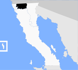
Municipio Tecate
| Tecate | ||
|---|---|---|

|
||
| Symbols | ||
|
||
| Basic data | ||
| Country | Mexico | |
| State | Baja California | |
| Seat | Tecate | |
| surface | 2,688.9 km² | |
| Residents | 101,079 (2010) | |
| density | 37.6 inhabitants per km² | |
| founding | 1833 | |
| Website | www.tecate.gob.mx | |
| INEGI no. | 02003 | |
| politics | ||
| Presidente municipal | Nereida Fuentes González | |
| Municipal Palace of Tecate | ||
Coordinates: 32 ° 30 ′ N , 116 ° 36 ′ W
Tecate is a municipality in the Mexican state of Baja California with a population of around 100,000. The municipality covers an area of approx. 2689 km². The administrative seat and largest place of the municipality is the Tecate of the same name .
geography
The municipality Tecate is located in the north of the state of Baja California inland at heights between 200 m and 1600 m . 98% of the municipality is part of the physiographic province of the Baja California Peninsula and 2% belongs to the plains of Sonora. 70% of the municipality are assigned to the hydrographic region of Baja California Noroeste , 4% Baja California Noreste and 26% drain over the Río Colorado into the Gulf of California . The geology of Tecates is dominated by intrusive rock , primarily granodiorite - tonalite (51%) and granite (9%), with about 17% metamorphic rocks , 6.5% sedimentary rock and 4% alluvial rocks . The predominant soil types are the Leptosol (67%) and Regosol (19%). Over 70% of the municipality is covered by scrub, around 16% is forested.
The municipality Tecate borders in the south with the municipality Ensenada , in the east with Mexicali , in the west with Tijuana and in the north with the US state California .
population
According to the 2010 census, the municipality has 101,079 inhabitants in around 26,000 residential units. Of these, 812 people were registered as speakers of an indigenous language , including 122 speakers of Purépecha and 101 speakers of Kumeyaay . About 2.4% of the population were illiterate. 41,575 residents were registered as economically active, of which approx. 65% were men and 5.2% were unemployed. 1.6% of the population lived in extreme poverty.
places
The municipality Tecate comprises 445 inhabited localidades , of which, in addition to the capital, Lomas de Santa Anita, Nueva Colonia Hindú and Luis Echeverría Álvarez are classified as urban by the INEGI . In the 2010 census, five towns had a population of over 2000, another seven towns had at least 500 inhabitants, and more than 400 towns had fewer than 100 inhabitants. The biggest places are:
| place | Residents |
| Tecate | 64,764 |
| Lomas de Santa Anita | 6,604 |
| Nueva Colonia Hindú | 4,431 |
| Cereso del Hongo | 4,278 |
| Luis Echeverría Álvarez ( El Hongo ) | 2.411 |
| Hacienda Tecate | 1,871 |
| Valle de las Palmas | 1,860 |
| La Rumorosa | 1,836 |
| Maclovio Herrera ( Colonia Aviación ) | 1,219 |
| Alfonso Garzón (Granjas Familiares) | 1,188 |
| El Mirador | 1,171 |
| Sierra Tecate | 585 |
Web links
- official website of Tecate (Spanish)
- Enciclopedia de los Municipios y Delegaciones de México: Municipio Tecate (Spanish)
- INEGI : Datos Geográficos: Municipio Tecate (Spanish; PDF)


