Municipio Ensenada
| Ensenada | |
|---|---|

|
|
| Basic data | |
| Country | Mexico |
| State | Baja California |
| Seat | Ensenada |
| surface | 53,199.8 km² |
| Residents | 466,814 (2010) |
| density | 8.77 inhabitants per km² |
| Website | ensenada.gob.mx |
| INEGI no. | 02001 |
| politics | |
| Presidente municipal | Marco Antonio Novelo Osuna |
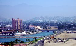
| Panorama of Ensenada | |
Coordinates: 30 ° 0 ′ N , 115 ° 30 ′ W
Ensenada is the largest municipio in area in Baja California and Mexico . With an area of 53,200 km², the population of the municipality in the 2010 census was 466,814. The administrative seat and largest city of the municipality with 280,000 inhabitants is the Ensenada of the same name . The municipality is further subdivided into 23 delegaciones and one subdelegación .
geography
The municipality covers most of the northern half of the Baja California peninsula plus some islands such as Isla de Cedros and Guadalupe . The highest point of the municipality is the Picacho del Diablo with 3096 m . 99% of the parish area is counted in the physiographic province of the Baja California Peninsula, one percent in the plains of Sonora. Geologically, the municipality is composed of a good 25% each of intrusive and extrusive rock , a good 20% of sedimentary rock , 13% of alluvion and almost 10% of metamorphic rock . The predominant soil types are the Leptosol (51%) and the Regosol (25%). More than 90% of the area of the municipality is taken up by undergrowth, about four percent are used for agriculture, a good two percent are forested.
The municipality of Ensenada borders in the north on the Municipios Playas de Rosarito , Tijuana , Tecate and Mexicali , in the east on the Gulf of California , in the south on the state of Baja California Sur and in the west on the Pacific .
population
According to the 2010 census, the community has around 467,000 inhabitants in around 129,000 residential units. Of these, 23,762 persons were registered as speaker of an indigenous language, including about 13,000 speakers of Mixtec and more than 3,000 speakers of Zapotec . About 4.7% of the population were illiterate. 206,680 inhabitants were registered as economically active, of which approx. 63% were men or 3.8% were unemployed. 5.7% of the population lived in extreme poverty.
places
The municipality of Ensenada comprises 1709 inhabited localidades , 19 of which are classified as urban by the INEGI . In the 2010 census, eight towns had a population of over 5,000, a further thirty towns had at least 1,000 inhabitants, and almost 1,600 towns had fewer than 100 inhabitants. The biggest places are:
| place | Residents |
| Ensenada | 279.765 |
| Rodolfo Sánchez Taboada ( Maneadero ) | 22,957 |
| Lázaro Cárdenas | 16,294 |
| Vicente Guerrero | 11,455 |
| El Sauzal de Rodríguez | 8,832 |
| Camalu | 8,621 |
| Benito García ( El Zorrillo ) | 6,598 |
| Emiliano Zapata | 5,756 |
| San Quintin | 4,777 |
| San Vicente | 4,362 |
| Colonia Lomas de San Ramón ( Triquis ) | 3,805 |
| Real del Castillo Nuevo ( Ojos Negros ) | 3,533 |
| Ejido papalote | 3,413 |
| Lázaro Cárdenas (Valle de la Trinidad) | 3,366 |
| Ejido México ( Punta Colonet ) | 3,278 |
| Colonia Nueva Era | 3,256 |
| Rancho Verde | 2,758 |
| Francisco Zarco ( Valle de Guadalupe ) | 2,664 |
| Santa Fe | 2,632 |
| Luis Rodríguez ( El Vergel ) | 2,281 |
Web links
- Official website
- Enciclopedia de los Municipios y Delegaciones de México: Municipio Ensenada (Spanish)
- INEGI : Datos Geográficos: Municipio Ensenada (Spanish; PDF)

