Ensenada
| Ensenada | ||
|---|---|---|
|
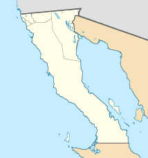
Coordinates: 31 ° 51 ′ N , 116 ° 36 ′ W Ensenada on the map of Baja California
|
||
| Basic data | ||
| Country | Mexico | |
| State | Baja California | |
| Municipio | Ensenada | |
| City foundation | September 17, 1542 | |
| Residents | 279,765 (2010) | |
| - in the metropolitan area | 466.814 | |
| City insignia | ||
| Detailed data | ||
| surface | 61.08 km 2 | |
| Population density | 4,580 inhabitants / km 2 | |
| height | 21 m | |
| Post Code | 22800-22899 | |
| prefix | (+52) 646 | |
| Time zone | UTC −8 | |
| City Presidency | Marco A. Novelo Osuna | |
| Website | ||
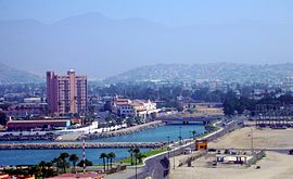
| panorama | ||
| Ensenada by night | ||
Ensenada is a city in the Mexican state of Baja California with about 279,765 inhabitants (as of 2010; 2005: 260,075) and the seat of the municipality of Ensenada with 466,000 inhabitants.
Ensenada is about 130 kilometers south of the Mexican - US border near Tijuana / San Diego on the Pacific coast .
In 2015, the city was named a UNESCO City of Gastronomy as part of the UNESCO Creative Cities Network project .
Ensenada has been the seat of the Roman Catholic diocese of Ensenada since 2007 . The cathedral is dedicated to Our Lady of Guadalupe .
history
The area of today's Ensenada was first reached in 1542 by the Portuguese Juan Rodríguez Cabrillo , flying the Spanish flag , who gave him the name San Mateo . 60 years later, in 1602, the Spaniard Sebastián Vizcaíno reached the place again and called it Ensenada de Todos Los Santos (the Bay of All Saints).
climate
|
Average monthly temperatures and rainfall for Ensenada 1951–2010
Source: Servicio Meteorologico Nacional
|
||||||||||||||||||||||||||||||||||||||||||||||||||||||||||||||||||||||||||||||||||||||||||||||||||||||||||||||||||||||||||||||||||||||||||||||||||||||
Economy and Infrastructure
- Around Ensenada is the most important wine-growing region in Mexico in terms of quantity . See also → Viticulture in Mexico
- Ensenada is a major seaport on the American Pacific coast .
- The 1711 kilometer long Mexican federal highway Carretera Federal 1 runs through the city, coming from Tijuana in the north and crossing the entire Baja California peninsula and ending in Cabo San Lucas in the extreme south .
- About ten kilometers south of the city is Ensenada Airport ( IATA code : ESE)
- In Ensenada is the Centro de Investigación Científica y de Educación Superior de Ensenada (CICESE), a well-known public university in Mexico. The Autonomous University of Baja California (UABC) also has a campus in Ensenada.
- The musical instrument manufacturer Fender operates a production facility in Ensenada.
Sports
Ensenada is the starting point of the Baja 1000 Rally , which ends after at least 1000 miles in Cabo San Lucas in the extreme south of Baja California and takes place in November. The Baja 500 also starts here, but ends again in Ensenada after a maximum of 500 miles. It will take place in June.
Town twinning
Sister cities of Ensenada are
all in California, USA
such as
sons and daughters of the town
- Nigel Bruce (1895–1953), British actor
- Herminio Masantonio (1910–1956), Argentinian football player
- Raúl Ramírez (* 1953), Mexican tennis player
Web links
- Website of the city of Ensenada (Spanish)
Individual evidence
- ↑ San Diego History Center - Ensenada ( English ), accessed on September 21, 2017
- ↑ Estado de Baja California-Estacion: Presa Emilio Lopez Zamora ( Memento from May 18, 2015 in the Internet Archive ). Climate 1951-2010 (in Spanish). Servicio Meteorologico Nacional. Retrieved July 15, 2015.
- ↑ Extreme Temperatures and Precipitation for Presa Emilio Lopez Zamora 1923–2007 ( Memento of May 18, 2015 in the Internet Archive ) (in Spanish). Servicio Meteorológico Nacional. Retrieved July 15, 2015.
- ↑ Port of Ensenada - Homepage | ( Spanish ), Retrieved September 21, 2017
- ↑ www.slideshare.net/EnsenadaEdc, p. 71 , accessed September 21, 2017


