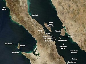
Isla Angel de la Guarda
| Angel de la Guarda | |
|---|---|
| Waters | Gulf of California |
| Geographical location | 29 ° 16 ′ N , 113 ° 22 ′ W |
| length | 69 km |
| width | 21 km |
| surface | 931.43 km² |
| Highest elevation | 1315 m |
| Residents | uninhabited |
| main place | Puerto de Refugio (formerly the whaling station) |
The Isla Ángel de la Guarda ( Seri : Xazl Iimt ) is the second largest island in the Gulf of California after the Isla Tiburón with an area of 931 km² . It belongs to the Mexican state of Baja California and there to the Municipio Mexicali , municipality ( delegación ) San Felipe . The 69 km long and up to 1315 m high island is located east of the Bay of Los Ángeles, not far from the Isla Tiburón.
Due to the very arid climate and the lack of drinking water, the island is uninhabited. However, it is rich in animal species that have adapted to the drought, such as rodents, lizards and snakes. These include endemic species such as the rattlesnake Crotalus angelensis , the island bush rat ( Neotoma insularis ) and the guarda deer vole ( Peromyscus guardia ). The island is under nature protection.
Individual evidence
- ↑ islands.unep.ch (English)

