Los Serranos
| map | |
|---|---|

|

|
| Basic data | |
| Country : | Spain |
| Region : | Valencia |
| Province : | Valencia |
| Capital : | Valencia |
| Surface: | 1,405 km² |
| Residents : | 17,936 |
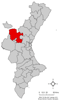
Los Serranos (or La Serranía) is a comarca in the province of Valencia in Spain . The traditional capital of the sparsely populated area is Chelva , while the municipality of Villar del Arzobispo has the largest population.
Communities
| place | Population (2019) |
Area ( km² ) |
Population density (inh. Per km²) |
|---|---|---|---|
| Alcublas | 628 | 43.51 | 14.43 |
| Alpuente | 633 | 138.33 | 4.58 |
| Andilla | 319 | 142.78 | 2.23 |
| Aras de los Olmos | 381 | 76.04 | 5.01 |
| Benagéber | 192 | 69.82 | 2.75 |
| Bugarra | 727 | 40.31 | 18.04 |
| Calles | 355 | 64.54 | 5.5 |
| Chelva | 1489 | 190.56 | 7.81 |
| Chulilla | 665 | 61.78 | 10.76 |
| Domeño | 708 | 68.80 | 10.29 |
| Gestalgar | 556 | 69.73 | 7.97 |
| Higueruelas | 500 | 18.80 | 26.6 |
| La Yesa | 229 | 84.68 | 2.7 |
| Losa del Obispo | 507 | 12.17 | 41.66 |
| Pedralba | 2778 | 58.85 | 47.2 |
| Sot de Chera | 369 | 38.75 | 9.52 |
| Titaguas | 453 | 63.21 | 7.17 |
| Tuéjar | 1116 | 121.92 | 9.15 |
| Villar del Arzobispo | 3554 | 40.70 | 87.32 |
geography
Los Serranos is bordered to the east by the Comarca Campo del Turia , to the south by Plana de Utiel-Requena and Hoya de Buñol , to the west by the Castilian province of Cuenca and to the north by the comarcas Alto Palancia and Gúdar-Javalambre and the Aragonese province of Teruel . The Sierra de Javalambre rises to the north and the Sierra del Negrete to the south . The land stretching between the mountain ranges is shaped by the course of the Río Turia .
Web link
Mancomunidad La Serranía website (Spanish)
Coordinates: 39 ° 41 ′ N , 0 ° 55 ′ W

