Luch on the Margaretenhöhe
|
Luch on the Margaretenhöhe
|
||
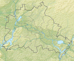
| location | Malchow , Germany | |
| surface | 2.5 ha | |
| Identifier | GLB-07 | |
| Geographical location | 52 ° 35 ' N , 13 ° 30' E | |
|
|
||
| Setup date | 5th September 1994 | |
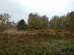
The Luch on Margaretenhöhe is a moorland and a protected landscape component in the Berlin district of Malchow in the Lichtenberg district . It is bounded to the west by the street An der Margaretenhöhe, the subsequent settlement, and extends to the north to Florentinestraße.
Protected position
The Luch on the Margaretenhöhe was declared a protected part of the landscape in accordance with Sections 18 and 22 of the Berlin Nature Conservation Act of January 30, 1979 (GVBl. P. 183) and last amended by Article V of the law of July 19, 1994 (GVBl. P. 241 ). The Protected Areas Ordinance came into force on September 5, 1994.
description
The Luch is 2.5 hectares , of which the realm moor is 0.8 hectares. It is located in a glacial meltwater channel that is cut 4–5 meters into the pebble till . The former swamp moor was in the lowlands of the lynx and consists of sedge and reed peat with a thickness of 0.4–2.6 meters. In addition, the small moor is in a depression on the base moraine plate of the Barnim , which is characterized by large fluctuations in the moor water level. The peat soil is refined to a depth of around 30 centimeters; in addition to the constantly existing reed portions, brown moss peat can also be found at greater depths. The reeds of the moor are monostructured and should develop as a eutrophic, peat-forming realm moor. The north-facing ditch should be examined because of the drainage effectiveness, whether a hydraulic engineering measure for better water retention would be possible.
The extensive Herzsee wetland, which used to be embedded, extended to the present settlement. The Margaretengraben begins in the Luch, flows over the Schälingsgraben, then into the river ditch and drains into the Panke . The 60-year-old Canadian black poplars have a far-reaching impact on the landscape there . When the afforestation in the area has reached a certain size, it should be gradually removed. For amphibians , dragonflies and breeding bird species tied to this habitat, reed and herbaceous meadows, willow bushes, silting areas and temporary still water areas offer good living and reproductive conditions .
Protection purpose and care
This part of the landscape must be permanently protected, the visual and ecological revitalization of the place and landscape must be preserved. In addition, it must be preserved in its entirety as well as animal and plant species typical for this habitat and for the water surface in detail. In 2004, the Environment and Nature Conservation Office created a maintenance and development plan that includes the following: The water situation must be stabilized, which was done via the bed sills in Margaretengraben and Schälingsgraben. One would like to slow down the silting process through maintenance work.
Web links
Individual evidence
- ↑ a b c d 1. Update of the landscape framework plan for the Lichtenberg district , PDF ; 1.935 MB
- ↑ a b Ordinance on the protection of the Luch landscape component on Margaretenhöhe in the Hohenschönhausen district of Berlin, Malchow district , PDF; 199 kB
- ^ Humboldt University, Soil Science: Luch an der Margaretenhöhe | Berlin peat soils in climate change. Retrieved October 23, 2018 .


