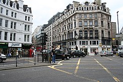
Ludgate Circus
| Ludgate Circus | |
|---|---|
| [[: Category: | Place in London]] | |

|
|
| Basic data | |
| place | London |
| District | City of London |
| Created | Between 1864 and 1875 |
| Confluent streets | Ludgate Hill , Fleet Street , Farringdon Street and New Bridge Street |
| use | |
| User groups | Pedestrians, cyclists, motorists, public transport |
| Technical specifications | |
| Square area | 1450 m² |
The Ludgate Circus is a crossing in the western city of London , where Farringdon Street, (together they form with the New Bridge Street A road 201 parts of the inner city ring), the Fleet Street and Ludgate Hill cross. The place has an area of approx. 1450 m².
Historically, the intersection forms the main link between the City of London and the City of Westminster and is located above the underground River Fleet . The circular square, which always served as a thoroughfare, but never as a roundabout despite its round shape , was built between 1864 and 1875. For this was granite from the Rock of Dartmoor in Devon used ( "Haytor").
In Charles Dickens ' Dictionary of London from 1879, the place was described as "Farringdon-circus".
The name of the intersection can be traced back to the Ludgate city gate , which was approx. 150 meters away on Ludgate Hill .
Train stations
On May 29, 1990, a train station was opened here under the name St Paul's Thameslink . At this point the Ludgate Circus station of the Fleet Line (now the Jubilee Line ) should have been built, but these plans were abandoned in the late 1970s. In 1991 the name was changed to City Thameslink to avoid confusion with the nearby St. Paul’s subway station .
Special
London's first public payphone was in the Ludgate Circus branch of Western Electric's British section in 1906 .
Individual evidence
- ↑ Charles Dickens: Victorian London - Districts Streets - Ludgate Hill . The Dictionary of Victorian London. 1879. Retrieved August 4, 2020.
- ^ Simon Webb: The Analogue Revolution: Communication Technology, 1901-1914 in the Google book search