
Lusancay Islands
| Lusancay Islands | ||
|---|---|---|
 |
||
| Waters | Solomon Lake | |
| archipelago | Louisiade Archipelago | |
| Geographical location | 8 ° 30 ′ S , 150 ° 30 ′ E | |
|
||
| Number of islands | 17th | |
| Main island | Kawa Island | |
| Total land area | 3.58 km² | |
| Residents | 290 | |

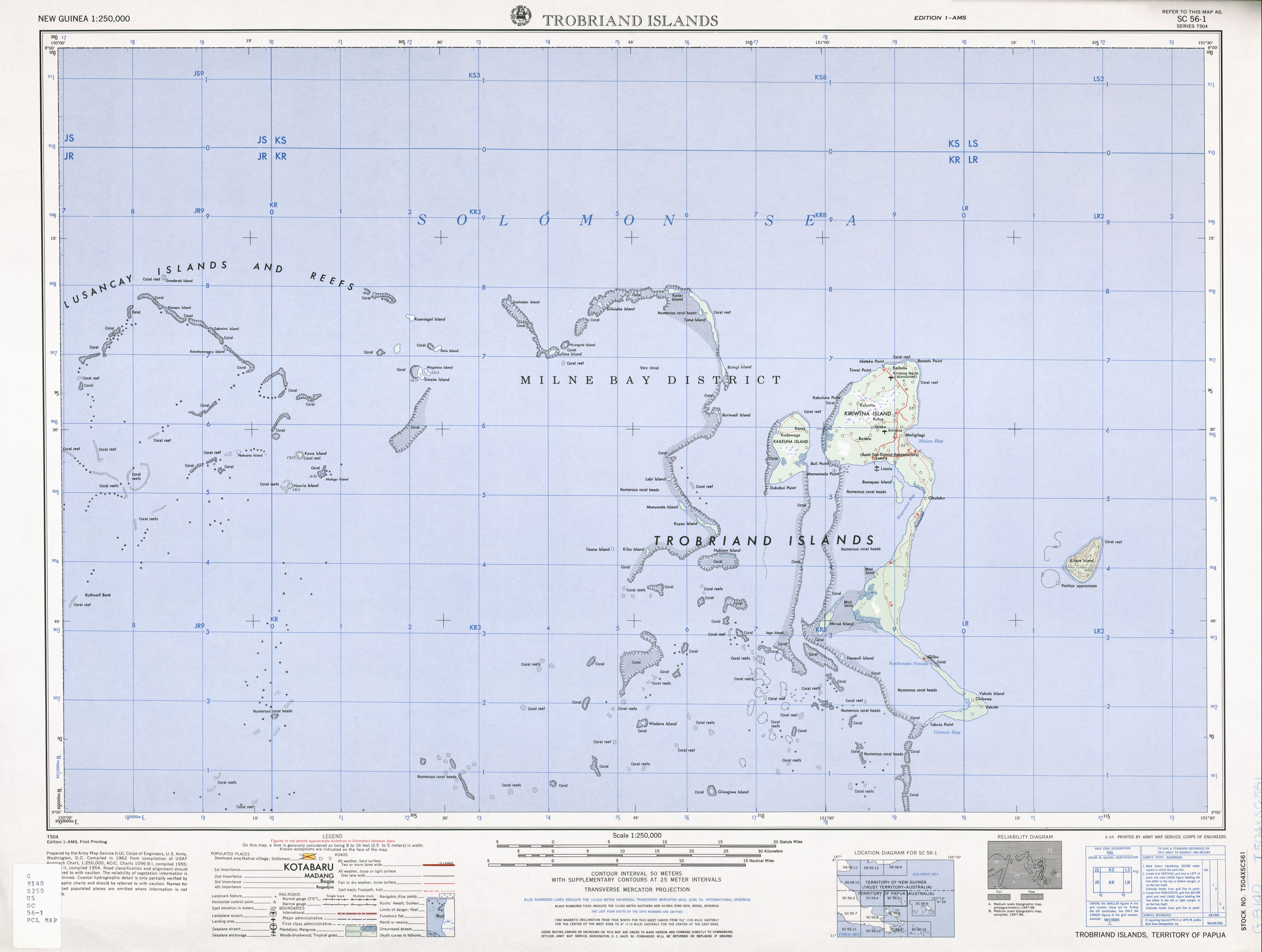
The Lusancay Islands are a group of around 17 islands in the Solomon Sea . Administratively, they belong to the Kiriwina Rural LLG (Local Level Government) Area of the Kiriwina-Goodenough District of the Milne Bay Province in the southeastern area of Papua New Guinea .
geography
The islands are located in the west of the Trobriand Islands . The distance of the easternmost island of Silipwaka is only 10.6 km west of Kadai Island in the northwestern area of the Trobriand Islands. They are also around 65 kilometers north of the D'Entrecasteaux Islands . With the Star Reefs to the west, the Lusancay Islands encompass a large area of shallow water, reefs, and islands stretching for 100 km from east to west and as far from north to south. Only the main island of Kawa and the island of Simsim (Konia) are inhabited, with 165 and 125 inhabitants respectively at the 2000 census. The main island of Kawa Island is the largest island in terms of area and population. Kwaiyaluma was probably also inhabited in the past. The easternmost of those named among the Lusancay Islands is Silipuaka (Silipwaka) .
Islands
The 17 islands are divided into an eastern, a southern and a western group (with area data from the PNAS extended islands database):
![]() Map with all coordinates: OSM | WikiMap
Map with all coordinates: OSM | WikiMap
Alternative area data exist in the literature for Gwadarab (7 ha ), Gabwina (26 ha), Simsim (64 ha), and Kawa (47 ha). However, these do not match the satellite image.
The NGA GEOnet Names Server lists the islands of Ebuna ( 8 ° 22 ′ 26 ″ S, 150 ° 28 ′ 10 ″ E), Nucuayayu Islets ( 8 ° 31 ′ 23 ″ S, 150 ° 13 ) in the Lusancay Islands area as not verified 25 ′ E), Kudalabi ( 8 ° 19 ′ 52 ″ S, 150 ° 5 ′ 27 ″ E), and Lifaba ( 8 ° 31 ′ 33 ″ S, 150 ° 2 ′ 52 ″ E ). At most, sandbanks or shallows can be made out on the satellite image .
Individual evidence
- ↑ Oceandots: Lusancay Islands and Reefs ( Memento of 26 September 2012 at the Internet Archive )
- ^ Gunter Senft: The Trobriand Islanders' Way of Speaking. 2010. ISBN 978-3-11-022798-7 , p. 132: In 1992 Tokunupei ... told me that Keli was a village on Kwaiyaluma Island, one of the Lusancay Islands. ( limited preview in Google Book search)
- ^ Pacific Islands Yearbook Volume 11, 1972 (at Google Books ). In this book, the southern islands of Matagu, Nauria, and Nukuana are incorrectly listed with the Laughland (Nada) Group , which is east of Woodlark Island . Otherwise, only Kwaiyaluma is not included in this list.
- ^ PNAS extended islands database. On the island of Kwaiyaluma , the name was added by the NGA GEOnet Names Server. The missing information for the very small islands of Deia and Nukuana was estimated from the satellite image.
- ^ Atoll Research Bulletin No. 180 (PDF; 1.3 MB)
- ↑ NGA GEOnet Names Server: Download Country Files: Papua New Guinea ( Memento of the original from July 9, 2012 in the Internet Archive ) Info: The archive link was inserted automatically and has not yet been checked. Please check the original and archive link according to the instructions and then remove this notice.