Lyttos
|
Local community Lyttos Τοπική Κοινότητα Λύττου (Ξιδά) |
||
|---|---|---|
|
|
||
| Basic data | ||
| Country |
|
|
| region | Crete | |
| Regional district | Heraklion (regional unit) | |
| local community | Minoa Pediada | |
| Parish | Kastelli | |
| Geographic coordinates | 35 ° 12 ′ N , 25 ° 22 ′ E | |
| Height above d. M. |
510 m |
|
| surface | 5,728 | |
| Residents | 234 (2011) | |
| LAU-1 code no. | 71060111 | |
| Local division | 1 | |
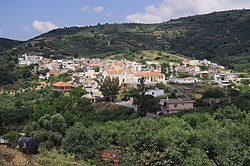
| View from the south | ||
Lyttos ( Greek Λύττος ) is a place on Crete in the municipality of Kastelli , in the municipality of Minoa Pediada . It is located on the western foothills of the Lasithi plateau . The place was first known as Xidas ( Greek Ξιδάς ) in 1368 . At the beginning of the 20th century it was named after the ancient city of Lyttos , about 800 m northeast . In 2011, with the administrative reform, the municipality of Lyttos ( Greek Δημοτικό Διαμέρισμα Λύττου ) was downgraded to a local community. In 1583, Petros Kastrofylakes reported that the place had 221 inhabitants.
The inhabitants live mainly from olive and wine growing. There is a primary school and four churches within the village: Agios Charalambos, Agios Titos, Agii Anargyri and Osios Stylianos. Of the many surrounding churches, two are particularly interesting. Agios Georgios is about 200 m west of the village. It is a single-nave church. An inscription dates it to the year 1321. It is decorated with frescoes depicting scenes from the life of St. George . Agios Nikolaos is on the road to Kastamonitsa about 800 m southeast of Lyttos. It is a single-nave church with frescoes from the mid-14th century. Antique stones were used in the churches.
Web links
- ΑΤΛΑΣ ΤΩΝ ΧΡΙΣΤΙΑΝΙΚΩΝ ΜΝΗΜΕΙΩΝ ΤΟΥ ΑΙΓΑΙΟΥ
- Lyttos or Xidas
- Church of Saint George in Lyttos (Xidas)
- Church of Agios Nikolaos (Saint Nicholas) in Lyttos (Xidas)
Individual evidence
- ↑ Results of the 2011 census at the National Statistical Service of Greece (ΕΛ.ΣΤΑΤ) ( Memento from June 27, 2015 in the Internet Archive ) (Excel document, 2.6 MB)

