
Makale (Sulawesi)
| Macals | |||
|---|---|---|---|
|
|||
| Coordinates | 3 ° 6 '17 " S , 119 ° 51' 12" E | ||
| Basic data | |||
| Country | Indonesia | ||
|
Geographical unit |
Sulawesi | ||
| province | Sulawesi Selatan | ||
| ISO 3166-2 | ID-SN | ||
| Kabupaten | Tana Toraja | ||
| surface | 39.8 km² | ||
| Residents | 32,257 (February 28, 2010) | ||
| density | 811.5 Ew. / km² | ||
 Lake in the city center
|
|||

Makale is the capital of the Indonesian administrative district ( Kabupaten ) Tana Toraja and its own district (Kecamatan). This belongs to the province of South Sulawesi , on the island of Sulawesi . About 30,000 people live in the city.
history
Makale is not an old town. It was planned by the Dutch in the 1920s.
traffic
A good road connects Makale with Rantepao (18 km) and Makassar, 310 km away. The Pongtiku airfield, about 10 km northwest of Makale, is currently (2015) being expanded into an international airport in order to better develop the Tana Toraja area for tourism. Direct flights to Singapore are planned for the near future. Until now there are only a few days a week flights from Pongtiku to Makassar, Samarinda and Poso.
particularities
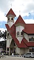
There is a lake in the city center, which is surrounded by well-kept green spaces. The city's most important public buildings are grouped around it. The monument of the freedom fighter Lakipadada, who came from Makale and is still popular with the population, rises on a small island in the lake. In contrast to the other cities in Indonesia, the cityscape of Makale is significantly shaped by church buildings. The evangelical church Gereja Toraja not far from the lake is visible from afar . Further striking church buildings were erected directly on the lake and on the hills surrounding the city.

Monument to the freedom fighter Lakipadada from Makale
Evangelical Church of Gereja Toraja

