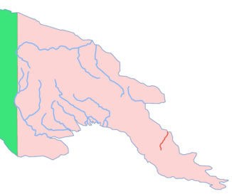
Mambare (river)
| Mambare | ||
|
Location of the Mambare in Papua New Guinea |
||
| Data | ||
| location | Papua New Guinea | |
| River system | Mambare | |
| muzzle |
Solomonensee , coordinates: 8 ° 2 '57 " S , 148 ° 0' 26" E 8 ° 2 '57 " S , 148 ° 0' 26" E |
|
| Mouth height |
0 m
|
|
| length | 200 km | |
| Catchment area | 23,309 km² | |
| Communities | Kokoda | |
|
False color image from space with the Mambare estuary |
||
The Mambare is a 200 km long river in the province of Oro in the southeast of Papua New Guinea . It flows through the village of Kokoda and flows into the Mambare Bay of the Solomon Sea near Mambatutu .
history
The army of the Japanese Empire had a supply warehouse at the mouth of the Mambaren during World War II .
Individual evidence
- ↑ Mambatutu. In: mapcarta.com. Retrieved August 17, 2018 .
- ↑ Mambare Bay. In: mapcarta.com. Retrieved August 17, 2018 .

