Manila Bay
| Manila Bay | ||
|---|---|---|
|
Satellite photo |
||
| Waters | South China Sea | |
| Land mass | Luzón | |
| Geographical location | 14 ° 31 ' N , 120 ° 46' E | |
|
|
||
| width | 48 km | |
| surface | 1 994 km² | |
| Coastline | 190 km | |
| Islands | Corregidor | |
| Tributaries | Pampanga , Pasig | |
|
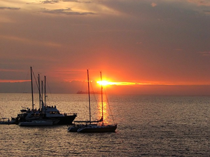
Sunset in Bay City, Pasay |
||
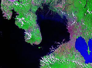
The Manila Bay is a natural harbor on the Philippine main island of Luzon .
The bay has a total area of 1994 km² and a coastline of 190 km in length. It provides natural protection for the port of Manila and a few other anchorages. The width of the bay is 19 km at the entrance to the open sea and extends to 48 km inland. Mariveles is an anchorage at the northern entrance to the bay, and Sangley Point was the US Navy's Cavite Naval Base until 1971 . There are other small ports in the north and south.
On both sides of the bay are volcanic hills that are overgrown by a tropical landscape. 40 km north of the port is the province of Bataan and in the south the province of Cavite . There are several islands in the entrance area of the bay. The largest of them is Corregidor . It divides the entrance of the bay into a 10.5 km wide southern and 3.2 km wide northern channel. In the relatively narrow passage around the island of Corregidor there have been repeated ship collisions with sometimes tragic results, for example the Cebu City ferry sank in December 1994 and the San Nicholas ferry in May 2003. In order to mitigate this potential risk, 2009 decided to set up a traffic separation area, which has been in force since January 2014.
Manila Bay is seen as one of the best natural harbors in Southeast Asia. Among other things, it was the scene of the battle in Manila Bay . This naval battle was the beginning and the first groundbreaking combat operation in the Spanish-American War in 1898.
In the Metro Manila area , the bay's coastline is densely populated. Some areas have been reclaimed from the sea and artificially fortified, for example the area in Pasay City , on which the Mall of Asia is located. To the southeast of the bay is the freshwater lake Laguna de Bay , the largest lake in the Philippines. It flows over the Pasig into the Manila Bay.
In recent years, the Manila Bay has been increasingly plagued by pollution. On the one hand, there is physical pollution from debris floating on the surface of the water, especially plastics. But very high concentrations of coliform bacteria can also be detected in the water of the bay due to wastewater that is often discharged untreated , which in some places exceed the limit values for bathing water by a million times. As early as 2008, the Supreme Court of the Philippines ordered the DENR (Department of Environment and Natural Resources) and other authorities to clean Manila Bay, restore water quality and protect it against future pollution. The main cause of the massive pollution is seen on the one hand as illegal settlements along the bay, the waste of which ends up in the sea unfiltered. But hotels and other commercial enterprises are also suspected of discharging untreated wastewater into the bay. However, nothing happened for years. Only after President Duterte brought the problem back into focus in mid-2018 and threatened to rigorously close companies if they continue to discharge uncleared wastewater into the bay, contrary to applicable laws, did the matter move. It is now being examined whether illegal settlements are to be dismantled and their residents relocated, commercial operations are being more strictly controlled and, in the event of violations, are receiving official cease-and- desist requests, and garbage collection campaigns, which were previously carried out mainly by NGOs and volunteers to clean the coasts of alluvial waste, now received broader support in one action coordinated by DENR, which started at the end of January 2019.
Individual evidence
- ↑ coastguard.gov.ph (archived version): Memorandum of an agreement between the Philippine Coast Guard and the Philippine Port Authority , accessed on March 24, 2019
- ↑ coastguard.gov.ph: ROUTEING SYSTEM AT CORREGIDOR ISLAND PASSAGES , accessed on March 24, 2019
- ↑ ABS-CBN: In pictures: what the Manila Bay looks like after a massive cleaning campaign , accessed on March 24, 2019
- ↑ manilatimes.net: DENR takes tougher action against pollution of Manila Bay , accessed on March 24, 2019
- ↑ ABS-CBN: DENR: drastic changes in the Manila Bay noticeable in 6 months at the earliest , accessed on March 24, 2019
- ↑ ABS-CBN: More companies because of the pollution of Manila Bay in the pillory , accessed on March 24, 2019


