
Mariakerke (Ghent)

Mariakerke is a sub-municipality of the Flemish city of Ghent . Mariakerke had 11,883 inhabitants at the end of 2007.
history

Mariakerke is an old village, the ground area of which consisted of almost 70 percent swamp, on what was left of the land stood estates such as today's Claeys Bouüaert and the St. Paul's seminar, there was only one road connection to Ghent, which is now to Genter Brugsesteenweg had developed.
Mariakerke became an independent community in 1793 and was given its definitive name at that time. Before that, in the written sources , e.g. from the 16th century, Merekercke , Meirekercke and Mariakercke were mentioned. The name Meeriskercke appeared in a document from the 15th century by Philip the Good .
Mariakerke has been cut through by the canal to Bruges, the "Brugger Fahrt" ( Brugse Vaart ), since the 17th century . The two halves were connected by the Mariakerkebrücke, which was destroyed several times during the various wars. Today's bridge dates from 1964. The two halves, Mariakerke-Zentrum and Mariakerke-Ost, have received their own character over the centuries. In the eighteenth century, Empress Maria Theresa laid the connection route with Eeklo, today's Belgian N9.
In the second half of the 19th century, many residents were drawn to Ghent's factories. Factory owners and wealthy townspeople built estates and castles here as country houses at the end of the 19th century. Most of these country estates have been preserved and make Mariakerke a real castle village (just like Vinderhoute and Lovendegem). Large country domains also belong to each of the country estates, most of which have also been preserved. As a result, Mariakerke has remained a “green village” to this day.
After the Second World War, the growth of Ghent brought the village under the great influence of thousands of townspeople.
In 1976 Mariakerke merged with Ghent and has been a sub-municipality of Ghent ever since.
geography
Mariakerke is on the edge of Meetjesland and is bordered by Wondelgem in the northeast, Gent in the southeast, Drongen in the southwest, Lovendegem in the northwest and Evergem in the north. The Brugse Vaart divides the village into Mariakerke-Zentrum and Mariakerke-Ost ( Kolegem ).
Demographic development

Bronnen: NIS en Stad Gent - Opm: 1806 t / m 1970 = volkstellingen; 1976, 1990, 2000 and 2007 = inwonertal op 31 december
Attractions
- De Onze-Lieve-Vrouw Maria Geboortekerk , church
- "Herberg Den Groenen Staek ", known as the inn and "Lustgarten" ("lusttuin")
- De pastorie (the rectory)
- De neo-Gothic galerij aan het kerkhof (neo-Gothic gallery, cemetery)
Castles and manors
- Claeys-Bouüaert Castle
- Castle La Maison Blanche
- Kasteel Kervyn d'Oudt Mooreghem
- Kasteel Les Fougères (or Les Cygnes)
- Kollekasteel
- Parkkasteel
- Kasteel Paul Van Tieghem (former parish hall of Mariakerke until 1977)
- Sint-Paulusseminarie or Kasteel Ter Beken

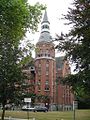
Claeys-Bouüaert Castle in rear view

Claeys-Bouüaert Castle in front view
Castle Paul Van Tieghem

St. Pauls seminar

Kasteel Henri Story (Wit Kasteel)


Green in and around Mariakerke
Mariakerke and especially Mariakerke-Ost has long remained a rural, boggy area around the rivers Durme , Kale and Lieve . The green character of Mariakerke is not only determined by the many country estates with attached parks, but also by the nature reserve Bourgoyen-Ossemeersen .
Like many villages and towns, Mariakerke has also been confronted by some traffic axes in the last few decades. Mariakerke has been cut by the Belgian N9 for a long time, but for the last few decades it has also been cut by the Ghent Ring R4, which now represents the actual border of Mariakerke in the north and west.
One of the most famous green spots in Mariakerke is “Pisbosje” near the N9. It belongs to the park at Van Tieghemkasteel (now called Roelandpark). This park was cut in two by the Mariakerkes bridge. The smallest part to the northwest is about an acre and has been on the news a few times since 1990. At the beginning of the nineties there were plans by the then owner (with the support of the city government) to clear everything here and to build a hamburger restaurant (hence the nickname "Hamburgerbosje"). After numerous protests from residents and youth associations, the city of Ghent decided to preserve this piece of greenery and an expropriation plan was drawn up. In 2007, however, there were again plans to exploit the area because the expropriation plan had expired and the various successive city governments had failed to make something of the plan. The Ghent city government probably bought the piece of park around the service center, but no more money was earmarked for the purchase of the “Hamburgerbosjes”, which should therefore have allowed development. New protests have moved the city leaders to hang up the plans and make use of emergency reserves to buy this piece of land.
Sports
Football club KSC Excelsior (KSCE) Mariakerke is a member of the KBVB and plays in the provincial league.
The Bourgoyen sports hall is located in Mariakerke-Zentrum.
Events
The annually recurring celebrations are among the most important events in Mariakerke. Shortly before May 1st, Zmerlief is celebrated, with activities all over the place, but particularly concentrated around the Claeys Bouüaert domain . Later in the year there are the Kollefeesten in and around the Kollekasteel in Mariakerke-Ost.
Well-known (ex) residents of Mariakerke
- Member of the eur. Parliament and former premier Guy Verhofstadt
- Former Mayor of Ghent Gilbert Temmerman
- Mayor of Ghent Daniel Termont
- Singer Koen Crucke
- Actor Kurt Defrancq
- Actor Jakob Beks
Web links
Coordinates: 51 ° 4 ′ N , 3 ° 40 ′ E