
Drongen


Drongen (earlier spelling: Dronghen , French Tronchiennes ) is the largest sub-municipality in terms of area of Ghent , the provincial capital of East Flanders in the Kingdom of Belgium . The place is on the Leie , west of the city center of Ghent. Drongen has 12,218 inhabitants (as of December 2007) and the official language is Dutch . For family conversations, however, the long -established residents of Drongens use the Drongens , which is a local dialect of the East Flemish dialect .
history
Prehistoric finds in Baarlevelde and Halewijn indicate an ancient settlement in this area. In Bourgoyen were Gallo-Roman finds discovered. Drongendorp developed around the Abbey of Drongen , the history of which goes back to the seventh century. The earliest mention of Drongens comes from 820, when it was mentioned as Truncinas . The abbey became a Norbertine abbey in the 12th century with the help of Iwein van Aalst .
Drongen was an old rule that originally belonged to the Count of Flanders. From the 11th century it fell to the House of Aalst and later to the Lords of Kortijk. Count Jean-Baptiste d'Hane-Steenhuyse became the last owner of the estate in 1786.
The nearby Baarle also has a history that goes back to the Middle Ages. On January 22nd, 1805, Baarle was abolished as an independent municipality by French imperial decree. To the left of the Leie the area fell to Drongen, to the right of the Leie to Sint-Martens-Latem . However, the parish remained independent.
The area remained relatively isolated for a long time. In 1823 the Drongensesteenweg was laid out, creating the first direct connection between the village and the city center of Ghent. The route became toll-free in 1889. In 1838 the Ghent-Bruges railway line was laid in an east-west direction; from now on it was an important new artery. Some companies settled in Drongen. In 1950 the E 40 was laid out; the connection helped Drongen to further increase its population. An industrial area was created near Baarle directly at the exit. The Ghent Ring followed in 1969, directly north of Drongen.
On January 1, 1977 Drongen lost its independence and merged with Ghent .

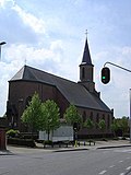
Sint-Gerolfkerk , Drongen Center
Sint-Martinuskerk , Baarle

Onze-Lieve-Vrouwekerk , Luchteren


geography
The largest sub-municipality of Ghent in terms of area covers an area of 27.43 km². In terms of population, however, Drongen is in fifth place, behind Sint-Amandsberg , Gentbrugge , Oostakker en Wondelgem . The place consists of three parishes and three village centers: Drongen-Zentrum, the still rural Luchteren and the more densely populated Baarle . Even there, individual hamlets and sub-areas can still be made out, for example Halewijn, which used to belong to Luchteren and had its own train station.
In a clockwise direction, Drongen borders the Ghent sub-municipalities of Mariakerke, Gent-Stadt, Sint-Denijs-Westrem and Afsnee , the center of Sint-Martens-Latem , Sint-Martens-Leerne near Deinze , Vosselare , Landegem and Merendree , which belong to Nevele , and Vinderhoute ( Lovendegem ).
Attractions
(Note. Only sights of Drongen-Zentrum were included here, not those of the other village centers of Baarle and Lucheren)
- Assels nature reserve , a lake area along the Leie
- The Drongenplein with St. Gerolf Chapel, St Gerolf Church,
- The Hoosmühle in the Bourgoyen-Ossemeersen nature reserve
- castle Kapellegoed
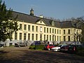
- The old Drongen Abbey
- The Byzantine style St. Joseph's Chapel
- The pastorei from 1773
- The Pont Bridge over the Leie
- The old Sint-Antone hostel, currently a lingerie shop

The "Old Abbey"

The pont bridge

De Piereput, part of the 'old Leie' in the Assels nature reserve

The Hoosmühle

The Baarlefähre which Baarle on the Lys with Sint-Martens-Latem links
The Kasteel De Campagne in Luchteren


Demographics
In 2007, Drongen had a share of foreigners of 1.3% and the unemployment rate was 3%.
Population development

Sources: NIS and City of Ghent - Note: 1806 to 1970 censuses; 1976, 1990, 2000 and 2007 residents on December 31.
traffic
The Drongen station is located in the center along the 50A railway line and is served every hour by the regional train between Ghent St. Pieters and Bruges Central Station. The station building has not been used for a long time and is to be demolished in the near future in order to make a track extension possible. Until 1984 Halewijn also had its own train station.
In Baarle there is an exit from the E 40, which explains the existence of the Drongen industrial park and the only hotel in the municipality.
Sports
Drongen has a football club KVE (Koninklijke Voetbalvereniging Eendracht) Drongen, which is a member of the KBVB. Each village center has its own field in which different teams play: On the Sint-Gerolfstraat, on the Noordgijzelstraat in Luchteren (near the Domein De Campagne country estate) and the Kloosterstraat in Baarle.
Personalities
According to some views, the addition of "von Tronje" to the figure of Hagen, which appears in various works of the Nibelung saga and in legends related to it, is derived from its origin or connection with the place Drongen
Lives in Drongen
- Rock singer Dirk Blanchart
- Singer Luk Bral
- Painter Antoon Catrie (he is een straat naar Catrie called)
- Actor, singer, author and former councilor Koen Crucke ( Open Vld ) (now in Ghent City)
- Footballer Kevin De Bruyne
- Rower Rita Defauw
- Singer and Junior Eurovision Song Contest 2010 participant Lauren De Ruyck
- Actress Griet Dobbelaere
- Author Jef Geeraerts
- Cyclist and cycling team boss Walter Godefroot (formerly, now in Sint-Martens-Latem )
- Film producer Dirk Impens (now living in Gent- Stad)
- Sculptor Domien Ingels (even a street is named after Domien Ingels.)
- Entrepreneur and former Belgian MP Peter Leyman ( CD&V )
- Mountain biker Filip Meirhaeghe
- Author, columnist, poet and partner of Lieven Vandenhaute Erwin Mortier
- Gymnaste Gaëlle Mys
- Soccer coach Jan Olde Riekerink (now residing in Porto , Portugal )
- Singer Sarah (Sarah De Koster)
- Journalist, moderator and partner of Erwin Mortier Lieven Vandenhaute
- Poet Julien Vangansbeke
Trivia
- In the Vinkendal in the Parochie Luchteren there is a Namibian honorary consulate with responsibility for the Flemish region.
- The radio station MNM broadcast live twice from Drongen, more precisely from the service area on the E40 in the direction of Brussels.
Web links
Coordinates: 51 ° 3 ′ N , 3 ° 40 ′ E