Marianne (island)
| Marianne | ||
|---|---|---|
| Waters | Indian Ocean | |
| Archipelago | Seychelles | |
| Geographical location | 4 ° 20 '30 " S , 55 ° 55' 16" E | |
|
|
||
| length | 1.9 km | |
| width | 800 m | |
| surface | 96.3 ha | |
| Highest elevation | Estel Hill 130 m |
|
| Residents | uninhabited | |
| main place | (La Cour) | |
Marianne (English: Marianne Island , French: Île Marianne ) is the second-easternmost granite island of the Seychelles after Frégate .
geography
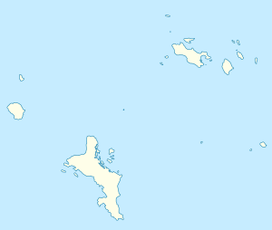
Marianne is 3.5 km southeast of Félicité and around 50 km northeast of Mahé , the main island of the Seychelles. The island is just under two kilometers long from Pointe aux Joncs in the north to Pointe Grand Glacis in the south. With a maximum width of 800 meters, it has an area of 0.963 km² (96.3 hectares) and in Estel Hill reaches a height of 130 m above sea level.
history
During the Marion Dufresne expedition in 1768, only a small amount of forest was found on the island.
At the beginning of the 19th century the island became private property, although lack of water hampered development. Maize was grown in abundance in the 1830s, and a coconut plantation was established for copra production in the early 20th century , which lasted into the 1970s. At the time, the island had about 50 to 60 inhabitants who lived in La Cour on the west side.
Today the island is uninhabited, but it is regularly visited by tourists and fishermen.
Animal world (fauna)
The rare Seychelles paradise flycatcher ( Terpsiphone corvina ) occurs on Marianne , and the island was also home to the recently extinct Marianne goggle bird ( Zosterops semiflavus ). There are also some gecko species, including Phelsuma sundbergi ladiguensis and Phelsuma astriata semicarinata .
