
Market (Eitorf)
The market in Eitorf is located in the center of the village and is partly a parking lot and pedestrian zone, partly it is part of Landesstraße 86.
Connection
The street part of the market connects Brückenstraße in the north and Asbacher Straße in the south. From here, Schmidtgasse and Schoellerstraße go off. Cäcilienstraße branches off from the actual square. The Turmgasse footpath leads to Eipstraße, a previous connection to Siegstraße and Leienbergstraße is closed by bollards .
Buildings
The following significant properties are located on the market:
- town hall
- the listed former Hotel Prinz Karl
Events
The market is not only the center of business life but also the center of most local events. On Tuesdays and Thursdays the Markt parking lot is closed in the mornings for a small weekly market . The Eitorfer Kirmes and the Eitorfer Spring , the Christmas market and two flea markets are held here. The KG Turm-Garde Eitorf organizes an open-air event with well-known artists on the market square at irregular intervals.
history
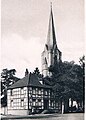
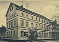
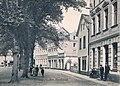
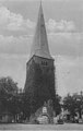
The market had been the location of the first two churches in Eitorf since around 1000 AD and, accordingly, a churchyard and therefore a cemetery . Dredging for lowering brought the corresponding bone finds to light. When the old church was demolished , the steeple was retained and became part of the municipal coat of arms as a landmark. The Bötticher distillery used to stand on the site of the current town hall . After the entrepreneur's conviction, his villa on Markt became the town hall in 1923. On October 16, 1913, Kaiser Wilhelm II drove through the market on a hunting trip. During the Second World War , the development of the market was totally destroyed by aerial bombs, except for Prince Karl , as was the town hall and the old tower .
The abandoned sexton's house on the corner of Asbacher Str./ Markt

Villa Bötticher and Hotel Gerlach on the west side, the church still without a tower

The new town hall in place of the Villa Bötticher
Hotel Prinz Karl in the original. Before it was called Hotel Engels.

House Prince Charles today
The neighboring houses of Prince Karl that were destroyed in the war

Corner of Markt / Siegstrasse before the war
The outlines of the old church tower are marked in the market paving

The car with the emperor leaves the market square, in the background the old "Löhr's Eck"


Individual evidence
- ^ Hermann Josef Ersfeld: Eitorfer Bild-Chronik, a contribution to local history 1850-1950, self-published, Eitorf 1980
- ^ Josef Ersfeld: Eitorfer Kriegschronik, 1950
Coordinates: 50 ° 46 ′ 12.9 ″ N , 7 ° 26 ′ 58.9 ″ E