Mayreau
| Mayreau | ||
|---|---|---|
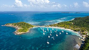
| Aerial view of the island - Salt Whistle Bay | ||
| Waters | Caribbean Sea | |
| Archipelago | Grenadines | |
| Geographical location | 12 ° 38 '30 " N , 61 ° 23' 27" W | |
|
|
||
| length | 2.8 km | |
| width | 1.6 km | |
| surface | 4 km² | |
| Highest elevation | 61 m | |
| Residents | 300 75 inhabitants / km² |
|
| main place | Old Wall | |
Mayreau is the smallest inhabited island in the Grenadines . It belongs to the Caribbean state of Saint Vincent and the Grenadines . Their land area is around four square kilometers. It reaches a height of 61 meters. The population is estimated at around 300 people. The island has only one road that leads from Saline Bay in the southwest through the only village of Old Wall to the Salt Whistle Bay Club on the bay of the same name in the northwest.
Web links
Commons : Mayreau - Collection of images, videos and audio files
Individual evidence
- ↑ Original information : 200 ft ( Memento of the original from March 4, 2016 in the Internet Archive ) Info: The archive link was inserted automatically and has not yet been checked. Please check the original and archive link according to the instructions and then remove this notice.

