
McArthur's Universal Corrective Map of the World
| McArthur's Universal Corrective Map of the World |
|---|
| Stuart McArthur , 1979 |
|
Link to the picture |
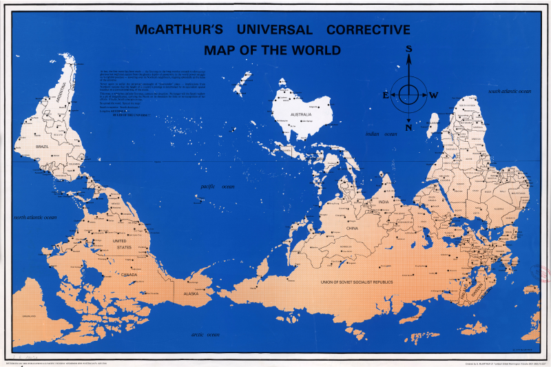
McArthur's Universal Corrective Map of the World is a south-facing map of the world published in 1979. The author is the Australian Stuart McArthur .
description
It is a world map in cylinder projection . The most noticeable difference to conventional maps is their orientation to the south, moreover the (not shown) prime meridian does not run through Greenwich , but through the Australian capital Canberra . The white highlighted Australia is not only on top, but also on the central axis. A representation of the Antarctic is missing, instead of this the title: McARTHUR'S UNIVERSAL CORRECTIVE MAP OF THE WORLD. Below on the left is a statement by the author and on the right an oversized compass rose with emphasis on the south. The usual coordinate system with longitudes and latitudes is missing, only the equator is shown. The names of the oceans are noted, as are political borders, country names and the most important locations.
Origin and background

The author Stuart McArthur (* 1958) says that even as a student he was bothered by the “disadvantaged” position of Australia on world maps. After being teased with Australian jokes by American friends during a visit to Japan that he came from "the bottom of the world", he decided to issue a "corrected" map of the world, with Australia in a privileged position. By the mid-2000s, nearly half a million copies had been sold. In the course of this success, other south-facing maps in various modifications were soon created. This new genus is known as upside-down maps , reversed maps or south-up maps .
The cartographic conventions on which today's viewing habits are based developed gradually over the course of history and are not mandatory. Although McArthur's southern map spontaneously appears to be "wrong", its representation of the world is just as plausible as that of the usual representations.
Individual evidence
- ↑ Ute Schneider: Die Macht der Karten , Primus Verlag 2006 ISBN 978-3-89678-292-2 p. 73, chapter: Innovations for cartography: projections and standardizations (with double-sided illustration of McArthur's map)
- ↑ Pim den Boer, u. a .: European places of remembrance 1 - Myths and basic concepts of the European self-image . Oldenbourg Verlag 2012 ISBN 978-3-486-70418-1 p. 222
- ↑ Patricia Fara: 4000 years of science , translated by Kamphuis Andrea. Springer Spectrum, 1st edition 2010 (introduction) ISBN 978-3-8274-2545-4
Web links
- Excellence Cluster Topoi: turned upside down! World pictures - picture worlds