Medan Merdeka

The Medan Merdeka ( Indonesian "Freedom Square" ) is a large square in the center of the Indonesian capital Jakarta . The square is about one square kilometer. During the Dutch colonial era it was called Koningsplein ("Königsplatz").
The square is now surrounded by important government buildings, such as the Merdeka Palais, a courthouse and various ministries. In the middle of the square is the National Monument of Indonesia, which commemorates the independence efforts of 1945-1949.
history
Koenigsplatz

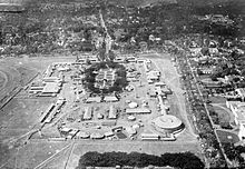
In the late 18th century, when the colonial administration of the Dutch East Indies moved from downtown Batavia (now Kota Baru) to Weltevreden (now Jakarta center), a number of significant buildings were built around the former "Buffalo Field", today's square. There were two important places in Weltevreden at the time: the Buffelsveld ("Buffalo Field ") and the Waterlooplein (now Lapangan Banteng ). These places were laid out during the rule of Herman Willem Daendels at the beginning of the 19th century; the Waterlooplein became the most important place for parades and other ceremonial occasions, while the Buffelsveld was renamed Champ de Mars ("Mars field"), which was due to the influence of the French and the use as a military training field. In 1818, shortly after the creation of the United Kingdom of the Netherlands , the square was renamed Koningsplein ("King's Square") in connection with the fact that the Governor General moved his seat to a new palace, also known as the Palais am Koningsplein . The colonial administration then built sports facilities, a running track and a stadium on the square. The local population called the place Lapangan Gambir ("Gambir Square"), which is reminiscent of the Uncaria gambir shrub that grows around the field. The Koningsplein became the place of the Gambir Jaarmarkt , the pasar malam ("night market") and the celebrations on Koninginnedag in honor of Queen Wilhelmina . The Gambir Jaarmarkt has been held annually since 1921 , which has continued under the name Jakarta Fair to this day. The name Koningsplein remained until the Japanese invasion in 1942.
Lapangan Ikada
During the Japanese occupation of the Netherlands Indies , the square was renamed Lapangan Ikada (an abbreviation of Ikatan Atletik Djakarta or Atletiek Bond Jakarta) in 1942 . Initially, the proclamation of Indonesia's independence was supposed to take place there, but then took place in a house in Jalan Pegangsaan (now Jalan Proklamasi). On August 17, 1945, Soekarno delivered his Indonesian Declaration of Independence combined with an anti-colonial and anti-imperialist speech.
After World War II, the Dutch colonial administration renamed the square back to Koningsplein.
Medan Merdeka
On December 27, 1949 - Independence Day, Sukarno renamed the square Medan Merdeka , which means "Freedom Square". Architectural competitions were announced in 1959 and 1960. However, Sukarno was not convinced by any of the designs, so no winner was announced. Instead, the former architecture student Sukarno had his own plans refined by architects. His design for the new Medan Merdeka was based on an unexecuted Dutch plan from 1892 with diagonal streets across the square.
Sukarno wanted the Indonesian people and the young independent nation after independence to have something to be proud of, a reminder of the struggle for independence. With this in mind, he had the National Monument built in 1961 (Indonesian: Monumen Nasional of Monas), which was completed in 1976. It was supposed to be Jakarta's tallest building, taller than Borobudur and taller than the Eiffel Tower in Paris. He had the sports facilities removed to make room for the monument.
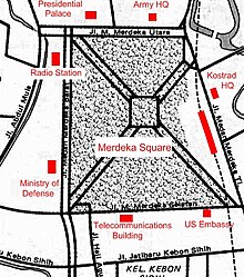
The Merdekaplatz is crossed by diagonal streets that form an "X". In the middle is the National Monument. The street is named Jalan Silang Monas and divides the square into four parts: North, East, South and West Park. The Jakarta Fair took place on the southern part from 1968 to 1992. The southwest corner was home to Taman Ria Jakarta, Jakarta's amusement park. The north, west and east of the square are still a park.
The design of the park remained relatively unchanged from the 1970s to the 1990s. The renovation in the 2000s gave the square its current appearance. The aim was to emphasize the function of the square as an open space and green environment. The grounds of the fair and the amusement park were closed in the early 1990s and turned back into a park. The area around the monument is closed to motorized traffic.
After Megawati was elected president in 2002 , Jakarta's governor Sutiyoso had a high fence with guarded gates built around the square. Visitors can enter the square for free, while street vendors, homeless people, beggars and other socially marginalized groups are excluded.
Today's design

Today's design is mainly based on the plan from the 1960s with streets crossing the square diagonally, dividing the square into four parts of the park. In the middle is the national monument. In the mid-1990s, renovation work began on the square to celebrate the 50th anniversary of independence, but it continued until the early 2000s. In this context, the roundabout was relocated further away from the monument because there was fear of damage to the monument from the vibrations of the traffic. Later it was decided to completely free the square from traffic. A larger central park was created and the asphalt road was replaced by paving with French stones and a large central square was created around the monument.
The Merdekaplatz consists of two zones:
- Taman Medan Merdeka (Medan Merdeka Park). In this area there are large trees, ponds and fountains. They border the very edge of the park near the footpath to the park.
- Ruang Agung (The Great Square). The second part is a large open space around the monument to improve its appearance and highlight it. It consists of lawns and borders around the monument, planted with colorful flowers and decorative plants.
Surroundings
The Medan Merdeka is the heart of Jakarta and Indonesia. Many important government buildings and cultural institutions are located around the square.
North side
|
East Side
|
South side
|
West side
|
Individual evidence
- ^ Kuoni - Far East, A world of difference. Kuoni Travel & JPM Publications, 1999, p. 93.
- ↑ a b Kim Dovey, Eka Permanasari: Monas and Merdeka Square. In: Kim Dovey: Becoming Places. Routledge, London / New York 2010, ISBN 978-0-415-41636-8 . P. 153 ff. (Limited display books.google.de ).
- ↑ Jakarta - Historic trip - Historic trip through the old city - Discover Indonesia Online. indahnesia.com, accessed March 21, 2016 .
- ↑ Tim Kindseth: Sense of Place: Jakarta . In: Time . December 2, 2009 ( time.com ).
- ^ Interest - Cultures - Jakarta. indo.com, accessed March 21, 2016 .
Coordinates: 6 ° 10 ′ 31 ″ S , 106 ° 49 ′ 38 ″ E


