
Memminger Strasse (Kempten)
| Memminger Strasse | |
|---|---|
|
|
|
| Basic data | |
| place | Kempten (Allgäu) |
| Hist. Names | Sonnenstrasse, Untere Gasse |
| Connecting roads | Salzstrasse, Altusrieder Strasse |
| Cross streets | Wartenseestraße, Prälat-Götz-Straße, Traubenweg, Landwehrstraße, Reitstallweg, Franz-Tröger-Straße, Stiftskellerweg, Madlenerstraße, Gottesackerweg, Adenauerring , Henggeweg, Äußere Rottach, Franz-von-Ried-Straße, Lotterbergstraße, Rottachstraße, Beim Floßerhäusle, Oberwanger Straße , Unterwanger Strasse, Thomas-Dachser-Strasse, Im Oberwang, Tobias-Dannheimer-Strasse, An der Stiftsbleiche , Am Ziegelstadel, Härtnagel , Wiggensbacher Strasse |
| Places | Stiftsplatz |
| use | |
| User groups | Pedestrians, cyclists, motorists, public transport |
| Technical specifications | |
| Street length | 3.2 km |
The Memminger Straße is one of the Kempten leading downtown street. It is based on an old country road to Memmingen . At over three kilometers, it is one of the long inner-city streets together with Lindauer Strasse and Kaufbeurer Strasse .
history
The Memminger Straße ended in penal times on the bridge over the Schlangenbach. From there the Untere Gasse led to the Bräuhausberg and the Großer Kornhausplatz . In 1890 Untere Gasse was renovated and renamed Sonnenstraße . In 1926 house numbering in Kempten was reformed; The Sonnenstrasse and Memminger Strasse from the former district hospital to the Johannisbrücke over the Rottach were combined to form Memminger Strasse.
With the renovation of Memminger Strasse towards the end of the 1960s, it became a main traffic axis through the city center.
Development
There are several important buildings along Memminger Strasse, including the Old Brewery, the Marstall with the Alpine Museum and the Alpine Gallery , the Kellerhof , the Latin Beck, the Trögerhaus, the former Catholic orphanage and numerous restaurants. After the Johannisbrücke are the Michaelskirche , built in the second half of the 20th century , the Dachser headquarters and the city's ice rink.
The brewery restaurant Zum Stift and the Stiftsbleiche are located near the street .

No. 5:
monastery malting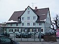
No. 7: Gasthof zur Goldenen Traube

No. 13:
Kellerhof
No. 16:
Latin Beck
No. 57:
Catholic orphanage
Former district hospital Kempten
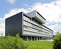
Dachser headquarters
.jpg)


.JPG)
.JPG)
.jpg)

Individual evidence
- ^ A b c Christian Ilg: City stories. The streets and houses of the municipality of Kempten (= From Kempten's past days. Vol. 4). Self-published, Kempten 2004, pp. 122–125.
Coordinates: 47 ° 44 ′ 0.7 " N , 10 ° 18 ′ 37.7" E