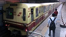
Kolkata Metro
The Kolkata Metro ( bengali : কলকাতা মেট্রো , Kolkātā Meṭro , Kolkata Metro ) is the underground railway of the Indian metropolis of Kolkata . It is operated by Indian Railways and was the first underground railway in India. From its opening in 1984 to the opening of the Delhi Metro in 2002, it was also the only one of its kind in the country. The fares are calculated according to zones, depending on the number of stations to be traveled.
The network currently consists of a line 22.3 km in length with 23 stations. The Indian broad gauge used underground is 5½ feet (1676 mm). The route runs from Dum Dum , near the airport , north of the city to Kavi Nazrul (Garia Bazar) in the south of the city.
history
The first plans for the construction of a subway in Kolkata existed as early as 1949. It took 35 years before the project was tackled. The first ramming for the construction of India's first subway took place on December 29, 1972 in the presence of the then Prime Minister Indira Gandhi . However, there was a lack of experience with building a subway, the financing was unsecured, the technical know-how was missing and there was a lack of materials at the beginning of the work. The construction work dragged on for twelve years, so that it was not until 1984 that the first 3.4 kilometer long section of the subway between the Esplanade and Bhowanipur stations (now Netaji Bhawan ) was put into operation. In the same year, a short, self-sufficient subway section between the two stations Dum Dum and Belgachia with a length of 2.1 kilometers followed in the north of Kolkata . It would be connected to the southern part of Line 1 in 1994.
line 1
| line 1 | |||||||||||||||||||||||||||||||||||||||||||||||||||||||||||||||||||||||||||||||||||||||||||||||||||||||||||||||||||||||||||||||||||||||||||||||||||||||||||||
|---|---|---|---|---|---|---|---|---|---|---|---|---|---|---|---|---|---|---|---|---|---|---|---|---|---|---|---|---|---|---|---|---|---|---|---|---|---|---|---|---|---|---|---|---|---|---|---|---|---|---|---|---|---|---|---|---|---|---|---|---|---|---|---|---|---|---|---|---|---|---|---|---|---|---|---|---|---|---|---|---|---|---|---|---|---|---|---|---|---|---|---|---|---|---|---|---|---|---|---|---|---|---|---|---|---|---|---|---|---|---|---|---|---|---|---|---|---|---|---|---|---|---|---|---|---|---|---|---|---|---|---|---|---|---|---|---|---|---|---|---|---|---|---|---|---|---|---|---|---|---|---|---|---|---|---|---|---|
|
A 3000 series train
| |||||||||||||||||||||||||||||||||||||||||||||||||||||||||||||||||||||||||||||||||||||||||||||||||||||||||||||||||||||||||||||||||||||||||||||||||||||||||||||
| Route length: | 23.3 km | ||||||||||||||||||||||||||||||||||||||||||||||||||||||||||||||||||||||||||||||||||||||||||||||||||||||||||||||||||||||||||||||||||||||||||||||||||||||||||||
| Power system : | 750 = | ||||||||||||||||||||||||||||||||||||||||||||||||||||||||||||||||||||||||||||||||||||||||||||||||||||||||||||||||||||||||||||||||||||||||||||||||||||||||||||
| Gauge : | 1676 mm ( Indian broad gauge ) | ||||||||||||||||||||||||||||||||||||||||||||||||||||||||||||||||||||||||||||||||||||||||||||||||||||||||||||||||||||||||||||||||||||||||||||||||||||||||||||
|
|||||||||||||||||||||||||||||||||||||||||||||||||||||||||||||||||||||||||||||||||||||||||||||||||||||||||||||||||||||||||||||||||||||||||||||||||||||||||||||
In the years that followed, the subway was continuously expanded and the two sections of the route in the north and south of the city were merged.
- 1986: Bhowanipur - Tollygunge (4.2 km)
- 1994: Belgachia - Shyambazar (3.8 km)
- 1994: Esplanade - Chandni Chowk (0.7 km)
- 1995: Shyambazar - Girish Park (1.9 km)
- 1995: Chandni Chowk - Central (0.6 km)
- 1995: Central - Girish Park (1.8 km)
- 2009: Tollygunge - Garia Bazar (Kavi Nazrul) (5.85 km)
- 2010: Garia Bazar - New Garia
On January 2, 2010 the foundation stone was laid for a northern extension of the route, it is to be extended from Dum Dum to Dakshineswar . Line 1 is held in the Indian broad gauge (1676 mm). The trains are supplied with (750 V direct current ) via a conductor rail and reach a top speed of 55 km / h. The average speed is 30 km / h. The fleet is currently to be expanded to include faster trains.
Line 2
Line 2 is under construction. This so-called East-West Metro will run from the east of the city to Howrah. The total length of the route is 14.67 km, of which 8.9 km are in the tunnel, while the eastern end is increased to 5.77 km. Like line 1, line 2 is also operated via a busbar with a voltage of 750 V. In contrast to line 1, however, line 2 is planned in standard gauge (1435 mm). The design speed is 80 km / h and therefore quite fast. Line 2 is operated by a separate company, Kolkata Metro Rail Corporation Ltd (KMRCL). A total of 12 stations are planned, six of them in the tunnel and six elevated. Line 1 is crossed at Central Station .
The stations in the order from west to east:
- Tunnel stations:
- Howrah Maidan
- Howrah (transfer to the train)
- Mahakaran
- Central (change to line 1)
- Sealdah (possibility to transfer to the train)
- Phool Bagan
- Stations on the surface:
- Salt Lake Stadium
- Bengal Chemical
- City Center
- Central Park
- Karunamoyee
- Salt Lake Sector-V
The first part of the route is scheduled to open in early 2018.
Further planning
Original plans envisaged a total of five underground lines with a total length of almost 100 km. A network of three lines is now planned for the long term.
Web links
Individual evidence
- ↑ http://www.bharatonline.com/west-bengal/travel/kolkata/metro.html
- ↑ Kolkata Metro
- ↑ http://www.thaindian.com/newsportal/business/mamata-lays-foundation-stone-of-kolkata-metro-extension_100298082.html
- ↑ http://www.indianexpress.com/news/Kolkata-Metro-to-buy-stateoftheart-coaches-for-TollygungeGaria-route/260295/
- ↑ Network map of the underground lines
- ^ The Hindu : East-West routes to become operational within two years, says Metro chief (July 9, 2015).


