Mile End (London Underground)
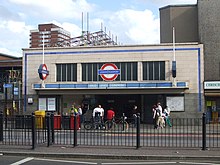
Mile End is an underground station in the London Underground district of Mile End in the London Borough of Tower Hamlets . It is in the Travelcard tariff zone 2, at the intersection of Mile End Road and Burdett Road. The Central Line , the District Line and the Hammersmith & City Line operate here . In 2014, 15.60 million passengers used this station served by the Central Line.
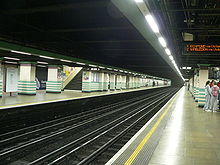
The station name is derived from a milestone that marked the point that is exactly one mile east of the border of the City of London . Mile End is the only underground station in the entire underground network where you can change to both line types on the same platform; on the one hand tube path (tube) , on the other hand Unterpflasterbahn (sub-surface) .
The station was opened on June 2, 1902 by the Whitechapel and Bow Railway , a joint venture of the Metropolitan District Railway (predecessor of the District Line) and the London, Tilbury and Southend Railway . The Metropolitan Line first served Mile End on March 30, 1936 (its branch to Barking was transferred to Hammersmith & City Line in 1988). The Central Line's tracks went into operation on December 4, 1946.
The Mile End Park is close to the station .
Web links
Individual evidence
- ↑ COUNTS - 2014 - annual entries & exits. (PDF, 44 kB) (No longer available online.) Transport for London, 2015, archived from the original on February 21, 2016 ; accessed on December 29, 2017 (English). Info: The archive link was inserted automatically and has not yet been checked. Please check the original and archive link according to the instructions and then remove this notice.
- ^ District Line. Clive's Underground Line Guides, accessed January 3, 2013 .
- ^ Hammersmith & City Line. Clive's Underground Line Guides, accessed January 3, 2013 .
- ↑ Central Line. Clive's Underground Line Guides, accessed January 3, 2013 .
| Previous station | Transport for London | Next station |
|---|---|---|
| Bethnal Green |
|
Stratford |
| Stepney Green |
|
Bow Road |
| Stepney Green |
|
Bow Road |
Coordinates: 51 ° 31 '31.1 " N , 0 ° 2' 1.3" W.

