
Minami-daitō
| Minami-daitō | ||
|---|---|---|
 |
||
| Waters | Philippine Sea | |
| Archipelago | Daitō Islands | |
| Geographical location | 25 ° 50 ′ 45 " N , 131 ° 14 ′ 30" E | |
|
||
| length | 6.54 km | |
| width | 5.6 km | |
| surface | 30.53 km² | |
| Highest elevation | 75 m | |
| Residents | 1305 (October 1, 2019) 43 inhabitants / km² |
|
| main place | Minamidaitō | |
 |
||

Minami-daitō ( Japanese 南大 東 島 , -jima / -shima , literally: "South Daitō Island", formerly: South Borodino Island ) is the largest and most populous island of the Japanese Daitō Islands in the Philippine Sea .
geography
The island is 9 km south of Kita-daitō , the second largest island in the archipelago, and about 360 km east of Naha on Okinawa , the seat of the prefecture. Like all Daitō Islands is also Minamidaitōjima an upscale Atoll with a steep cliff coastline of limestone - the former fringing reef of the atoll - as well as a deeper level in the interior of the island today are some small lakes. Minami-daitō has a length of 6.54 km, a circumference of 21.2 km and an area of 30.53 km². The island, which is surrounded by a coral reef , reaches a height of up to 75 m above sea level on the coast .
Administratively, the island belongs to the Okinawa Prefecture and forms the municipality of Minamidaitō ( 南大 東村 ) there. Minami-daitō has 1305 inhabitants (as of October 1, 2019), most of whom live in a settlement in the southwest of the island's interior. In the east is the airport of Minami-daitō ( 南大 東 空港 , Minamidaitō Kūkō , IATA code: MQD, ICAO code: ROMD) with a 1500 m long runway.
- Views
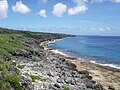
The cliffs of Minami-daitō

A pond in the deeper interior of the island

People and goods have to be brought to the island by crane


history
It is possible that the originally uninhabited islands of Minami and Kita-daitō were discovered by the Spaniard Pedro de Unamuno on July 28, 1587 and named Islas sin Probecho . Despite wrong coordinates , a sighting of the British captain John Meares on April 5, 1788, who named the islands Grampus Isles , is considered certain. On July 2, 1820, the two closely spaced islands were rediscovered by the Russian lieutenant Sachar Ponafidin, named after his ship Borodino , and their position correctly determined. 1899 began the Japanese settlement of the island with residents of Hachijō-jima ; as a result, the mining of guano and the reclamation began with the cultivation of mainly sugar cane .
Web links
- Official website of the Minamidaitō Community (Japanese)
- Page about Minami-daitō ( Memento from September 17, 2008 in the Internet Archive ) (English)
- Short portrait at Oceandots ( Memento from December 23, 2010 in the Internet Archive )
Individual evidence
- ↑ 指定 離島 ・ 指定 離島 一 覧 . (PDF) In: 離島 関係 資料 (平 成 28 年 1 月) . 沖 縄 県 企 画 部 地域 ・ 離島 課 (“Land and Islands Unit, Planning Department, Okinawa Prefecture”), January 2016, p. 1 , accessed on 1. August 2016 (Japanese).
- ↑ 排 他 的 経 済 水域 等 の 基礎 と な る 低潮 線 を 有 す る 離島 に 関 す る 調査 . (PDF) (No longer available online.) 内閣 官 房 総 合 海洋 政策 本部 事務 局 (“…, Cabinet Secretariat ”), March 2011, p. 9 , archived from the original on June 12, 2012 ; Retrieved December 15, 2012 (Japanese). Info: The archive link was inserted automatically and has not yet been checked. Please check the original and archive link according to the instructions and then remove this notice.
- ↑ Minamidaitō - Official Site (Japanese)