Mindoro Street
| Mindoro Street | ||
|---|---|---|
| Connects waters | South China Sea | |
| with water | Sulu Lake | |
| Separates land mass | Mindoro (Philippines) | |
| of land mass | Busuanga (Philippines) | |
| Data | ||
| Geographical location | 12 ° 20 ′ 0 ″ N , 120 ° 40 ′ 0 ″ E | |
|
|
||
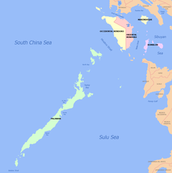
The Mindoro Strait ( English Mindoro Strait ) is a strait in the Philippine archipelago and connects the South China Sea in the northwest of the Sulu Sea in the southeast.
In the southwest is the island of Busuanga , which belongs to the Calamian Islands, in the northeast of Mindoro .
For ships larger than the Malaccamax class that cannot navigate the Malacca Straits , the Mindoro Strait is part of the route from the Indian Ocean to the Pacific .
To the north of the road is the famous Apo Reef and the Apo Reef Marine Natural Park . On this reef there is a lighthouse that is important for shipping (coordinates: 12 ° 40 ′ N , 120 ° 25 ′ E ).

