Monkredding House
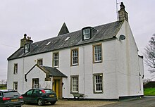
Monkredding House is a country house in the town of Kilwinning in Scotland administrative unit North Ayrshire . The property on the B778 trunk road between Kilwinnung and Auchentiber originally belonged to the Tironensier monks from Kilwinning Abbey ; it was the "Mönchsgarten", a retirement home for the brothers. Monkcastle near the village of Dalgarven was the abbot's country residence. Monkredding House is still in good condition and is used as a private residence.
history
Between 1539 and 1545 the Nevin family purchased the estates of East and West Monkredding from Alexander , Abbot of Kilwinning Abbey. Thomas Nevin was the first secular owner of these lands, “part of the old Halydom of Kilwinning, which the abbots divided up around this time and sold to those who best rewarded them for the alleged gift because they foresaw their own possessions in doubt and would become discontinuous ”. The old name of the place is given as "Moncarden" or "Monks Garden".
Savio writes that “Thomas Nevin acquired the lands of East Monkredding in 1539, Guslone and Bannach in 1543, and West Monkredding and Gaitmureland in 1545. In addition to securing the lease, the lease granted the tenant the right to mine his land. Thomas Nevin was able to mine coal on his leased land and sell it. His family got so rich that they could have a Tower House built in Monkredding. "
The cottage
Thomas Nevin , the first laird, was successful in the coal mining business and rich enough to begin building what is now the country house. Monkredding House, sometimes also Monkreddin House , is a small, often converted fortress with an L-shaped floor plan, which today has a large, modern extension from 1905 at the rear. It was built according to plans by Hugh Thomson , an architect who worked in Saltoaks . Thomson also built the vestibule and probably the Edwardian lodges.
The Monkredding House consists of three wings that enclose a square courtyard; the north side is open. The western wing and the stair tower are old. The west wing has a date stone on the north gable, on which the year of construction 1602 or 1605 is recorded; the rest was added in 1638, as noted on the gable of a dormer window on the west wall. The lower floor has a vaulted ceiling . The masonry is plastered with rough Harl and whitewashed. The roof was lowered. The round stair tower was increased significantly. There are no more dormers and the stepped gables have been removed. The 17th century building was enlarged and remodeled in the early 19th century; the main facade and the central entrance are now on the south side. Historic Scotland has listed Monkredding House as a Category B Historic Building.
As mentioned above, the tower has been raised, presumably to its original height. This was part of the restoration work the MacAlisters had carried out, as was the enlargement of one of the two loopholes into a window. Alexandrina MacAlister said the back door was once the main entrance and the building may once have served as the Peel Tower .
In 1895 the house was described by McMichael as a ruin; a building without a roof, known as a ruin, is shown in the 1st edition (1858) of the 6-inch Ordnance Survey Map, sheet XII.
The property
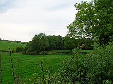
The map from 1775 shows a country house with large estates, planted with sparse forest, just like Thomson's map from 1820. In the 1920s, an old beech tree fell over in the park of Monkredding House; it was found to be around 400 years old. A number of large beech trees are still standing on the street opposite the old entrance, part of the old lands before the new street was built.
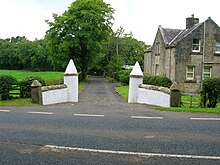
There is also a pleasure house listed as a Category C historical building on the site. The Ordnance Survey maps show that the first entrance from the road to Auchentiber with its Golconda Lodge was closed, presumably because of limestone work, and that today's entrance with its Edwardian Monkredding Lodge was built as a replacement. Before the construction of the trunk road, the entrance was on the former road from Kilwinning to Beith at Laigh Gooseloan , which continues via Jameston and Drambuie . Thomson's 1832 map shows an entrance that runs along today's road straight up to the house. Golconda is a ruined city in south-central India , west of Hyderabad , and the capital of an ancient kingdom (approx. 1364–1512). It is not known how the lodge was named.
The estate
The property was approximately 280 acres and was later expanded to over 400 acres; it contained all 12 farms: Monkredding East, Monkredding West, Hullerhill, Crofthead, Bannoch, Gooseloan, Corshill, Gaitmuirland, Nether Mains, Boutriehill, Lylestone and Goldcraig.
In 1691 the following people and stoves were recorded on the property in the “stove control roles”: Monkroding house 6; John Kilpatrick,; John Langwill 1; Janet Reid 1; John Lockart 1; Robert Montgomrie 1; Meran Kilpatrick 1; John Reid 1; John Niving 1
Mining
Coal mining and spoil heaps in Monkredding near Kilwinning recorded Timothy Pont 1608, which extended together with the limestone on 20-40 hectares. Quarries and coal pits were so close to the country house that its entrance had to be relocated.
“The Monkridding estate has old coal heaps associated with limestone seams 2½ to 3 feet thick that were excavated hundreds of years ago and span 50 to 100 acres. This coal deposit must have been of great value in those days of inadequate machinery because of the special stores of coal and the location of the land, as everything was made anhydrous, and there is now a constant outflow of fine water from the old spoil. There is still a large part of the lower edge [of the seam] to be extracted. Receipts for coal from this mining area, dating back to 200 years ago, were found in the Blair's papers. "
The Monkredding quarry with its associated smithy and railroad was a fine-grain quarry with an attached settlement, limestone quarry and coal pits, as seen on the 6-inch Ordnance Survey map. The Inspector of Mines' report of 1874 lists monkredding among the twelve active mines in the Irvine area .
The coal seam Monkridden No. 1 was abandoned before 1879 and Wee Coal and Limestone was still operating in 1877. The Goldcraig limestone quarry closed in 1891 and the Wee coal mine was abandoned in 1927. Lylestone had wee coal and clay pits . The upper mines were closed in 1918.
Individual evidence
- ^ John Ness: Kilwinning Encyclopedia . Kilwinning & District Preservation Society, 1990. p. 65.
- ↑ a b c d e f Chapter Five: Nevin in Ayrshire . In: Nevin Genealogica . Ancestry.com. Retrieved November 22, 2017.
- ^ A b c Robert Close: Ayrshire and Arran: An Illustrated Architectural Guide . Royal Incorporation for Archeology in Scotland, 1992. ISBN 1-873190-06-9 . P. 88.
- ↑ James D. Dobie, JS Dobie (editor): Cunninghame, Topographized by Timothy Pont 1604-1608, with continuations and illustrative notices . John Tweed, Glasgow 1876. p. 331.
- ^ Sister Dominic Savio: Kilwinning Abbey . 1988. p. 23.
- ↑ Dane Love: Ayrshire: Discovering a County: Ayr . Fort Publishing, 2003. ISBN 0-9544461-1-9 . P.56.
- ↑ Hugh Thomson . In: Dictionary of Scottish Architects . ScottishArchitects.org.uk. Retrieved November 22, 2017.
- ^ A b Nigel Tranter: The Fortified House in Scotland. Volume 3, South-West Scotland . The Mercat Press, Edinburgh 1977. p. 22.
- ^ Mike Salter: The Castles of South-West Scotland . Folly, Malvern 2006. ISBN 1-871731-70-4 . P. 54.
- ↑ Entry on Monkredding House in Canmore, the database of Historic Environment Scotland (English)
- ↑ Listed Building - Entry . In: Historic Scotland .
- ↑ George McMichael: Notes on the Way Through Ayrshire. Ayr . Hugh Henry, 1895. p. 165.
- ↑ Andrew Armstrong's Map . Retrieved on August 27, 2010. ( Page no longer available , search in web archives ) Info: The link was automatically marked as defective. Please check the link according to the instructions and then remove this notice.
- ↑ Thomson's Map . Retrieved on August 26, 2010. ( Page no longer available , search in web archives ) Info: The link was automatically marked as defective. Please check the link according to the instructions and then remove this notice.
- ↑ Entry on Monkredding House in Canmore, the database of Historic Environment Scotland (English)
- ^ Roy Military Survey of Scotland - Roy Highlands 1747-52 . Retrieved November 22, 2017.
- ^ Northern Part of Ayrshire - Southern Part . In: John Thomson's Atlas of Scotland . 1832. Retrieved November 22, 2017.
- ^ The 1691 Hearth Tax Rolls of Ayrshire . Ayrshire Roots. Retrieved November 22, 2017.
- ↑ James D. Dobie, JS Dobie (editor): Cunninghame, Topographized by Timothy Pont 1604-1608, with continuations and illustrative notices . John Tweed, Glasgow 1876. pp. 332-333.
- ↑ John Straw Horn: The History of Irvine. Royal Burgh and Town . John Donald, Edinburgh 1985. ISBN 0-85976-140-1 . P. 154.
- ^ Mines Department: Catalog of Plans of Abandoned Mines . His Majesty's Stationary Office, London 1931. p. 59.
- ^ Mines Department: Catalog of Plans of Abandoned Mines . His Majesty's Stationary Office, London 1931. p. 45.
- ^ Mines Department: Catalog of Plans of Abandoned Mines . His Majesty's Stationary Office, London 1931. p. 56.
Web links
Coordinates: 55 ° 40 ′ 24.6 ″ N , 4 ° 40 ′ 0.9 ″ W.


