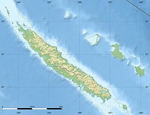
Mont Humboldt
| Mont Humboldt | ||
|---|---|---|
|
Mont Humboldt |
||
| height | 1618 m | |
| location | New Caledonia ( southern province , border of the municipalities of Païta , Thio and Yaté ) | |
| Mountains | Massif du Humboldt | |
| Coordinates | 21 ° 53 '2 " S , 166 ° 25' 13" O | |
|
|
||
The Mont Humboldt ( German " Berg Humboldt " ), named after Alexander von Humboldt , is the second highest mountain in New Caledonia with a height of 1618 m after Mont Panié . It lies in the mountains of the Massif du Humboldt .
The higher areas of the mountain have been a nature reserve since 1950 (Réserve spéciale botanique du Mont Humboldt).
About one kilometer west of the summit is the Refuge du Mont Humboldt ( ⊙ ). The masonry hut offers 8 beds and is not managed. It's about an hour to the summit from the hut.
Web links
Commons : Mont Humboldt - Collection of images, videos and audio files
- Mont Humboldt. In: le guide de Nouvelle-Calédonie. Retrieved November 30, 2014 (French).
Individual evidence
- ^ Province Sud ›Geography. Retrieved November 30, 2013 (French).
- ↑ geoportail.fr. Retrieved November 30, 2014 .
- ^ Refuge du Humboldt. Retrieved November 30, 2014 (French).

