Paita
| Paita | ||
|---|---|---|
|
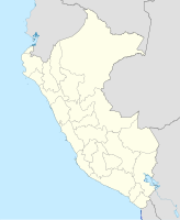
Coordinates: 5 ° 5 ′ S , 81 ° 6 ′ W Paita on the map of Peru
|
||
| Basic data | ||
| Country | Peru | |
| region | Piura | |
| province | Paita | |
| City foundation | March 30, 1532 | |
| Residents | 81,163 (2017) | |
| City insignia | ||
| Detailed data | ||
| height | 3 m | |
| Waters | Pacific Ocean | |
| City Presidency | Teodoro Alvarado Alayo (2019-2022) |
|
| Website | ||
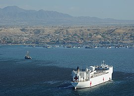
| City view from the sea | ||
| Commercial space | ||
Paita (formerly: San Francisco de la Buena Esperanza) is a port city on the Pacific Ocean in northwest Peru . The city is located in the Paita district of the same name and in the Paita province of the Piura region . Paita is located 640 km northwest of the state capital Lima and 90 km northwest of the regional capital Piura .
location
The port city of Paita is located on a peninsula south of the mouth of the Río Chira . Paita is located on the "Bay of Paita", protected from the south wind by the Punta Paita headland with the Silla de Paita ridge . The port is the second most important in Peru after that of Callao .
The regional center of Piura is 90 km south of Paita and Chiclayo , the commercial center of the Lambayeque region, is 160 km to the south .
population
In the 2017 census, the population of Paita was 81,163, 10 years earlier it was 66,548.
history
From 1578 to 1588 Paita was the Spanish capital of the Peruvian north-west coast, but the constant attacks by English pirates and corsairs made it necessary to move the capital to today's Piura.
The port city of Paita is known to many Peruvians as the former residence of Manuela Sáenz , the lover of the liberation hero Simón Bolívar .
Economy and Infrastructure
In 1875 a 97 km long railway connection between Piura and Paita was completed, destroyed in the Saltpeter War with Chile (1879-1883) and put back into operation in 1884. From August 30, 1891 until the late 1920s, there was also a tram line in Paita.
Today the seaport of Paita is Peru's fifth largest port and a major container port. It is located in a geopolitically important location on the Pacific coast, because this is where a railway connection over the Andes to Puerto Limon , which connects to the Brazilian Maraflon on the upper reaches of the Amazon, ends .
Paita is one of the best natural harbors on the Peruvian coast, from here there are regular boat connections to Valparaíso and Panama .
Festivals
On September 24th every year the "Fiesta de Nuestra Señora de las Mercedes" is celebrated for one week, including a. with pilgrimages in honor of the Virgin Mary.
Individual evidence
- ^ Peru: Piura Region - Provinces & Places . www.citypopulation.de. Retrieved December 23, 2019.


