
Piura region
| Piura region | |||
|---|---|---|---|
 .svg) |
|||
| Symbols | |||
|
|||
| Basic data | |||
| Country | Peru | ||
| Capital | Piura | ||
| surface | 35,891 km² | ||
| Residents | 1,844,100 (2015) | ||
| density | 51 inhabitants per km² | ||
| ISO 3166-2 | PE-PIU | ||
| Website | www.regionpiura.gob.pe (Spanish) | ||
| politics | |||
| Gobernador regional | Servando García Correa (2019-2022) | ||
 |
|||


Coordinates: 5 ° 9 ′ S , 80 ° 34 ′ W
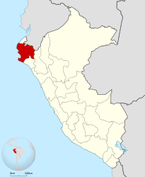
The region of Piura [ pjuɾa ] (Spanish Región Piura , Quechua Piwra suyu ) is a region in northwestern Peru . 1,844,100 people (2015) live in an area of 35,891 km². The capital is Piura . The region and city were named after the Piura River.
geography
The region borders the Pacific to the west and Ecuador to the north . Bordering regions of Peru are Cajamarca , Lambayeque and Tumbes .
The landscape is rather flat and characterized by desert areas like in the province of Sechura.
The Vicús culture settled in this region and was known for its ceramic and goldsmith work.
Provinces
The region is divided into eight provinces and 64 districts.
| province | Capital |
|---|---|
| Ayabaca | Ayabaca |
| Huancabamba | Huancabamba |
| Morropón | Chulucanas |
| Paita | Paita |
| Piura | Piura |
| Sechura | Sechura |
| Sullana | Sullana |
| Talara | Talara |
Web links
Amazon | Ancash | Apurímac | Arequipa | Ayacucho | Cajamarca | Callao | Cusco | Huancavelica | Huánuco | Ica | Junín | La Libertad | Lambayeque | Lima | Loreto | Madre de Dios | Moquegua | Pasco | Piura | Puno | San Martín | Tacna | Tumbes | Ucayali
Lima Province (region-free area of the capital)