Piura River
| Piura River | ||
|
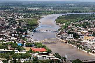
Río Piura in the city of Piura |
||
| Data | ||
| location |
|
|
| River system | Piura River | |
| Headwaters |
Cordillera Occidental 5 ° 41 ′ 56 " S , 79 ° 35 ′ 13" W. |
|
| Source height | approx. 2200 m | |
| muzzle | Virrilá Estuary, Pacific Ocean Coordinates: 5 ° 46 ′ 11 ″ S , 80 ° 52 ′ 6 ″ W 5 ° 46 ′ 11 ″ S , 80 ° 52 ′ 6 ″ W |
|
| Mouth height | 0 m | |
| Height difference | approx. 2200 m | |
| Bottom slope | approx. 6.2 ‰ | |
| length | approx. 355 km | |
| Catchment area | 12,216 km² | |
| Left tributaries | Río Seco | |
| Right tributaries | Río Pusmalca, Río Bigote, Río Corrales, Río San Jorge, Río Yapatero, Río Sancor, Quebrada San Francisco | |
| Flowing lakes | Lake La Niña | |
| Big cities | Piura | |
| Medium-sized cities | Chulucanas , Tambogrande | |
| Communities | Parachique | |
The Río Piura is an approximately 355 km long tributary of the Pacific Ocean in northwestern Peru . The Río Piura drains an area of 12,216 km².
River course
The Río Piura rises in the Cordillera Occidental on the western edge of the Andes . The headwaters are located in the south of the Huancabamba province at an altitude of about 2200 m . The Río Piura initially flows 160 km in a north-westerly direction. The rivers Río Pusmalca , Río Bigote , Río Corrales , Río San Jorge , Río Yapatero , Río Sancor and Quebrada San Francisco flow into the Río Piura from the right and Río Seco from the left. This flows through the province of Morropón and passes its administrative seat Chulucanas . Later the Río Piura reaches the province of Piura .
At river kilometer 195, the city of Tambogrande is on the northern bank of the river. Then the Río Piura flows 45 km to the west and finally turns south. At river kilometer 120 the river flows through the city of Piura . It is spanned by several road bridges. The last 80 km of the Río Piura runs within the province of Sechura . Between river kilometers 55 and 37 the Río Piura flows through the lake Lago La Niña . Then the Río Piura turns west. The trunk road 1N crosses the river 9 km above its mouth into the sea. Below the road bridge, the Río Piura merges into the approximately 9 km long Virrilá estuary (Estuario de Virrilá), which opens to the Pacific Ocean at Parachique .
The river water of the Río Piura is used to irrigate agricultural areas on the lower reaches. North of the city of Piura there is a weir ( ⊙ ) on the river . An irrigation canal branches off from this on the eastern side.
![]() Map with all coordinates: OSM | WikiMap
Map with all coordinates: OSM | WikiMap
Floods
On March 27, 2017, flooding occurred in the lower reaches of the Río Piura due to its strong water flow of 3700 to 3900 m³ / s.
Web links
Individual evidence
- ↑ a b Cuenca e hidrografía del Rio Piura . Ministerio de Agricultura y Riego, Perú. Retrieved March 13, 2019.
