
Arequipa region
| Arequipa region | |||
|---|---|---|---|
 .svg) |
|||
| Symbols | |||
|
|||
| Basic data | |||
| Country | Peru | ||
| Capital | Arequipa | ||
| surface | 63,345.4 km² | ||
| Residents | 1,287,200 (2015) | ||
| density | 20 inhabitants per km² | ||
| ISO 3166-2 | PE-ARE | ||
| Website | www.regionarequipa.gob.pe (Spanish) | ||
| politics | |||
| Gobernador regional | Elmer Cáceres Llica (2019-2022) |
||
 |
|||


Coordinates: 16 ° 18 ′ S , 71 ° 30 ′ W
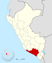
The Arequipa region ( Spanish Región Arequipa , Quechua Ariqipa suyu ) is a region in southern Peru . 1,287,200 people (2015) live in an area of 63,345.39 km². The capital is Arequipa .
geography
Arequipa is located on the Pacific Ocean . The coast is partly rocky and inaccessible, partly characterized by sandy beaches suitable for bathing. A few rivers flow in deep valleys from the Andes down to the Pacific and enable irrigated agriculture . The interior of the country is generally very dry and rises gradually to the majestic volcanic chain ( Cordillera Volcánica ), the highest peak of which is the ice-covered Coropuna at 6,425 meters. Behind the volcanic chain, the Altiplano slowly begins to expand, the vast plateau, which is divided here by a few other mountain ranges.
The Sierra Arequipas is criss-crossed by deep gorges such as the Cotahuasi Cañon or the Colca Cañon , which is considered the deepest gorge in the world.
Cities
The city of Arequipa is the dominant economic, political and cultural center of the region. The two main port cities are Mollendo and Matarani .
Provinces
The Arequipa region is divided into eight provinces and 109 districts:
| province | Residents 2015 | surface | Capital |
|---|---|---|---|
| Arequipa | 969.284 | 9,682 km² | Arequipa |
| Camaná | 58,952 | 3,998 km² | Camaná |
| Caravelí | 40.904 | 13 140 km² | Caravelí |
| Castilla | 38,670 | 6,914 km² | Aplao |
| Caylloma | 94,220 | 14,019 km² | Chivay |
| Condesuyos | 17,943 | 6,958 km² | Chuquibamba |
| Islay | 52,630 | 3,886 km² | Mollendo |
| La Unión | 14,602 | 4,746 km² | Cotahuasi |
Individual evidence
- ↑ INE 2007
- ↑ Peru: Administrative Division (Regions and Provinces) - Population Statistics, Charts and Map. Retrieved May 14, 2018 .
Web links
Amazon | Ancash | Apurímac | Arequipa | Ayacucho | Cajamarca | Callao | Cusco | Huancavelica | Huánuco | Ica | Junín | La Libertad | Lambayeque | Lima | Loreto | Madre de Dios | Moquegua | Pasco | Piura | Puno | San Martín | Tacna | Tumbes | Ucayali
Lima Province (region-free area of the capital)