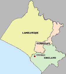
Lambayeque region
| Lambayeque region | |||
|---|---|---|---|
| Symbols | |||
|
|||
| Basic data | |||
| Country | Peru | ||
| Capital | Chiclayo | ||
| surface | 14,213 km² | ||
| Residents | 1,197,260 (2017) | ||
| density | 84 inhabitants per km² | ||
| ISO 3166-2 | PE-LAM | ||
| Website | www.regionlambayeque.gob.pe (Spanish) | ||
| politics | |||
| Gobernador regional | Anselmo Lozano Centurión (2019-2022) |
||
| Provinces of the Lambayeque region | |||
Coordinates: 6 ° 42 ′ S , 79 ° 52 ′ W
The Lambayeque region [ lambaˈʝeke ] (Spanish Región Lambayeque , Quechua Lanpalliqi suyu ) is an administrative region in northwestern Peru . 1,197,260 people live in an area of 14,213 km² (2017). The capital is Chiclayo . The pre-Inca cultures of Chimú , Mochica and Sicán (Lambayeque) existed in this region .
geography
The islands of Punta Chérrepe, Lobos de Tierra and Lobos de Afuera belong to the region on the Pacific Ocean .
Provinces
The Lambayeque region is divided into three provinces and 38 districts.
| province | Capital |
|---|---|
| Chiclayo | Chiclayo |
| Ferreñafe | Ferreñafe |
| Lambayeque | Lambayeque |
population
The majority Spanish-speaking population is concentrated in the coastal province of Chiclayo.
In the remote districts of Incahuasi and Kañaris , which belong to the province of Ferreñafe, there is still a predominantly Quechua-speaking population ( Inkawasi-Kañaris ). Muchik was also spoken on the coast until the beginning of the 20th century .
Web links
- Regional government of the Lambayeque region
- The largest pyramid center in the world , ZDF , July 8, 2007
- Peru: 4000 year old temple discovered . In: Spiegel Online - Wissenschaft , November 12, 2007


